Podcast
Questions and Answers
ଭାରତର ଉତ୍ତର ସୀମାରେ କେଉଁ ପର୍ବତଶ୍ରେଣୀ ଅବସ୍ଥିତ?
ଭାରତର ଉତ୍ତର ସୀମାରେ କେଉଁ ପର୍ବତଶ୍ରେଣୀ ଅବସ୍ଥିତ?
- ହିମାଳୟ (correct)
- ପୂର୍ବ ଘାଟ
- କାରାକୋରମ
- ପଶ୍ଚିମ ଘାଟ
ଭାରତର ଦୀର୍ଘତମ ନଦୀ କାଉଁ?
ଭାରତର ଦୀର୍ଘତମ ନଦୀ କାଉଁ?
- ଗଙ୍ଗା (correct)
- କୃଷ୍ଣା
- ଇନ୍ଦୁସ
- ବ୍ରହ୍ମପୁତ୍ରା
ଭାରତର ମୁଖ୍ୟ କୃଷି ଋତୁ କାଉଁ?
ଭାରତର ମୁଖ୍ୟ କୃଷି ଋତୁ କାଉଁ?
- ଗ୍ରୀଷ୍ମ ଋତୁ
- ଶୀତ ଋତୁ
- ବସନ୍ତ ଋତୁ
- ମନସୂନ ଋତୁ (correct)
ଭାରତର କେଉଁ ଦ୍ୱୀପପୁଞ୍ଜ ବଙ୍ଗାଳ ଉପସାଗରରେ ଅବସ୍ଥିତ?
ଭାରତର କେଉଁ ଦ୍ୱୀପପୁଞ୍ଜ ବଙ୍ଗାଳ ଉପସାଗରରେ ଅବସ୍ଥିତ?
ଭାରତର କେଉଁ ରାଜ୍ୟରେ କାରାକୋରମ ପର୍ବତଶ୍ରେଣୀ ଅବସ୍ଥିତ?
ଭାରତର କେଉଁ ରାଜ୍ୟରେ କାରାକୋରମ ପର୍ବତଶ୍ରେଣୀ ଅବସ୍ଥିତ?
ଭାରତର ଉତ୍ତର ସୀମାରେ କେଉଁ ଦେଶର ସୀମାରେ ଲାଗିଛି?
ଭାରତର ଉତ୍ତର ସୀମାରେ କେଉଁ ଦେଶର ସୀମାରେ ଲାଗିଛି?
ଭାରତର ଦୁଇଟି ଉପସାଗରରେ ଲକ୍ଷଦ୍ୱୀପ ଅବସ୍ଥିତ?
ଭାରତର ଦୁଇଟି ଉପସାଗରରେ ଲକ୍ଷଦ୍ୱୀପ ଅବସ୍ଥିତ?
Flashcards are hidden until you start studying
Study Notes
Geography of India
Location and Extent
- Located in South Asia
- Lies between 8°4' and 37°6' N latitude
- Extends from 68°7' to 97°25' E longitude
- Shares borders with Pakistan, Afghanistan, China, Nepal, Bhutan, Bangladesh, and Myanmar
Physical Features
- Mountains:
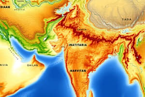
- Himalayas: world's highest mountain range, runs along northern border
- Karakoram range: located in Jammu and Kashmir
- Eastern Ghats: discontinuous range along eastern coast
- Western Ghats: continuous range along western coast
- Plains:
- Indo-Gangetic Plain: fertile plain between Himalayas and Vindhya range
- Deccan Plateau: triangular plateau in central India
- Islands:
- Andaman and Nicobar Islands: union territory in Bay of Bengal
- Lakshadweep Islands: union territory in Arabian Sea
Rivers
- Major Rivers:
- Ganges: longest river in India, flows from Himalayas to Bay of Bengal
- Indus: flows from Himalayas to Arabian Sea
- Brahmaputra: flows from Himalayas to Bay of Bengal
- Godavari: flows from western Ghats to Bay of Bengal
- Krishna: flows from western Ghats to Bay of Bengal
- Tributaries:
- Yamuna: tributary of Ganges
- Kosi: tributary of Ganges
- Gandaki: tributary of Ganges
Climate
- Types:
- Tropical: near equator, hot and humid
- Subtropical: northern India, hot summers and cold winters
- Temperate: Himalayan region, cold winters and mild summers
- Seasons:
- Summer: March to May
- Monsoon: June to September
- Winter: December to February
Natural Resources
- Minerals:
- Iron ore
- Coal
- Manganese
- Mica
- Forest Cover:
- About 20% of India's land area is forested
- Types: tropical, subtropical, and temperate forests
ଭାରତର ଭୂଗୋଳ
ଅବସ୍ଥାନ ଏବଂ ପରିମାଣ
- ଦକ୍ଷିଣ ଏସିଆରେ ଅବସ୍ଥିତ
- ୮°୪' ଏବଂ ୩୭°୬' ଉତ୍ତର ଅକ୍ଷାଂଶରେ ଅବସ୍ଥିତ
- ୬୮°୭' ଏବଂ ୯୭°୨୫' ପୂର୍ବ ଦ୍ରାଘିମାରେ ବିସ୍ତୃତ
- ପାକିସ୍ତାନ, ଆଫଗାନିସ୍ତାନ, ଚୀନ, ନେପାଲ, ଭୁଟାନ, ବାଂଲାଦେଶ, ଏବଂ ମିଆନ୍ମାର ସହିତ ସୀମା ଭାଗରେ ଅବସ୍ଥିତ
ଭୌତିକ ଅଙ୍ଗ
- ପର୍ବତମାଳା:
- ହିମାଳୟ: ଦୁନିଆର ସର୍ବୋଚ୍ଚ ପର୍ବତମାଳା, ଉତ୍ତର ସୀମାରେ
- କାରାକୋରମ ପର୍ବତମାଳା: ଜମ୍ମୁ ଏବଂ କାଶ୍ମୀରରେ ଅବସ୍ଥିତ
- ପୂର୍ବ ଘାଟ: ପୂର୍ବ ଉପକୂଳରେ ଅବସ୍ଥିତ
- ପଶ୍ଚିମ ଘାଟ: ପଶ୍ଚିମ ଉପକୂଳରେ ଅବସ୍ଥିତ
- ମାଳଭୂମି:
- ଇନ୍ଦୋ-ଗଙ୍ଗା ମାଳଭୂମି: ହିମାଳୟ ଏବଂ ଭିନ୍ଧ୍ୟା ପର୍ବତମାଳା ମଧ୍ୟରେ ଅବସ୍ଥିତ
- ଦକ୍ଷିଣ ମାଳଭୂମି: କେନ୍ଦ୍ରୀୟ ଭାରତରେ ଅବସ୍ଥିତ
- ଦ୍ୱୀପ:
- ଆନ୍ଦାମାନ ଏବଂ ନିକୋବର ଦ୍ୱୀପ: ବଙ୍ଗାଳ ଉପସାଗରରେ ଅବସ୍ଥିତ
- ଲକ୍ଷଦ୍ୱୀପ: ଆରବିୟା ସାଗରରେ ଅବସ୍ଥିତ
ନଦୀ
- ପ୍ରମୁଖ ନଦୀ:
- ଗଙ୍ଗା: ଭାରତର ସର୍ବାଧିକ ଲମ୍ବା ନଦୀ, ହିମାଳୟରୁ ବଙ୍ଗାଳ ଉପସାଗରରେ
- ଇନ୍ଦୁସ୍: ହିମାଳୟରୁ ଆରବିୟା ସାଗରରେ
- ବ୍ରହ୍ମପୁତ୍ର: ହିମାଳୟରୁ ବଙ୍ଗାଳ ଉପସାଗରରେ
- ଗୋଦାବରୀ: ପଶ୍ଚିମ ଘାଟରୁ ବଙ୍ଗାଳ ଉପସାଗରର
Studying That Suits You
Use AI to generate personalized quizzes and flashcards to suit your learning preferences.


