Podcast
Questions and Answers
The largest and deepest of the world's oceans, covering approximately 30.5% of the Earth's surface, is the ______ Ocean.
The largest and deepest of the world's oceans, covering approximately 30.5% of the Earth's surface, is the ______ Ocean.
Pacific
Known as the second largest and busiest ocean, the ______ Ocean is shaped like the letter 'S' and contains significant shallow seas such as the Caribbean Sea.
Known as the second largest and busiest ocean, the ______ Ocean is shaped like the letter 'S' and contains significant shallow seas such as the Caribbean Sea.
Atlantic
Surrounding Antarctica, the ______ Ocean is largely covered by ice sheets throughout the year and includes adjacent seas like the Scotia Sea and Ross Sea.
Surrounding Antarctica, the ______ Ocean is largely covered by ice sheets throughout the year and includes adjacent seas like the Scotia Sea and Ross Sea.
Southern
The ______ Ocean, unique for being named after a country, is primarily located in the southern hemisphere and is bordered by Africa, Asia, and Australia.
The ______ Ocean, unique for being named after a country, is primarily located in the southern hemisphere and is bordered by Africa, Asia, and Australia.
The smallest of the world's oceans, the ______ Ocean, is located north of the Arctic Circle and is surrounded by the landmasses of North America, Asia, Greenland, and Europe.
The smallest of the world's oceans, the ______ Ocean, is located north of the Arctic Circle and is surrounded by the landmasses of North America, Asia, Greenland, and Europe.
Due to the ______ coastline of the Atlantic Ocean, there are many sites for natural harbors.
Due to the ______ coastline of the Atlantic Ocean, there are many sites for natural harbors.
The ______ is a spectacular underwater mountain range on the Atlantic Ocean floor, running roughly down to the center of the ocean floor.
The ______ is a spectacular underwater mountain range on the Atlantic Ocean floor, running roughly down to the center of the ocean floor.
The ______ extensions of the Indian Ocean are the Bay of Benegal and the Arabian Sea.
The ______ extensions of the Indian Ocean are the Bay of Benegal and the Arabian Sea.
While earthquakes are hard to foresee, a ______ potential can be warned within three hours, especially with systems like those in the Pacific Ocean.
While earthquakes are hard to foresee, a ______ potential can be warned within three hours, especially with systems like those in the Pacific Ocean.
The rhythmic rise and fall of seawater levels are known as ______, primarily caused by the gravitational forces of the Moon and the Sun.
The rhythmic rise and fall of seawater levels are known as ______, primarily caused by the gravitational forces of the Moon and the Sun.
During the full Moon and the new Moon phases, the Earth, Moon, and Sun align, resulting in higher than usual tides known as ______ tides.
During the full Moon and the new Moon phases, the Earth, Moon, and Sun align, resulting in higher than usual tides known as ______ tides.
Ocean water is constantly in motion, exhibiting both vertical and horizontal movements primarily influenced by temperature, density, salinity variations, and the effect of ______ winds.
Ocean water is constantly in motion, exhibiting both vertical and horizontal movements primarily influenced by temperature, density, salinity variations, and the effect of ______ winds.
The shape and size of ocean waves are highly dependent on the speed of the wind, with other weather conditions also playing a role in determining their characteristics, such as wavelength and ______.
The shape and size of ocean waves are highly dependent on the speed of the wind, with other weather conditions also playing a role in determining their characteristics, such as wavelength and ______.
When the Sun and Earth's gravitational forces pull ocean water in opposite directions during the first and last quarters of the moon, lower tides known as ______ tides occur.
When the Sun and Earth's gravitational forces pull ocean water in opposite directions during the first and last quarters of the moon, lower tides known as ______ tides occur.
Tides assist in keeping the mouths of rivers open for ships by clearing away ______ and silt deposits.
Tides assist in keeping the mouths of rivers open for ships by clearing away ______ and silt deposits.
Tsunamis, also known as harbour waves, are often caused by underwater earthquakes. The 2004 Indian Ocean tsunami resulted from an earthquake with an epicenter near Sumatra that measured 9.0 on the ______ scale.
Tsunamis, also known as harbour waves, are often caused by underwater earthquakes. The 2004 Indian Ocean tsunami resulted from an earthquake with an epicenter near Sumatra that measured 9.0 on the ______ scale.
When the Indian plate subducted under the Burma plate forming the 2004 tsunami, the ocean floor experienced a sudden ______ of about 10-20 meters, leading to large-scale water displacement.
When the Indian plate subducted under the Burma plate forming the 2004 tsunami, the ocean floor experienced a sudden ______ of about 10-20 meters, leading to large-scale water displacement.
The predictable nature of tides makes them a promising source of renewable energy, leading to the establishment of ______ power stations in several countries.
The predictable nature of tides makes them a promising source of renewable energy, leading to the establishment of ______ power stations in several countries.
As the water mass rushed back towards the coastline after a tectonic shift, the tsunami's speed reached approximately 800 km/hour, comparable to that of a commercial ______.
As the water mass rushed back towards the coastline after a tectonic shift, the tsunami's speed reached approximately 800 km/hour, comparable to that of a commercial ______.
Continuous, directional movement of ocean water is described as an ______ current, greatly influencing maritime climates.
Continuous, directional movement of ocean water is described as an ______ current, greatly influencing maritime climates.
The southernmost point of India, known as the Indira Point, was completely ______ during the 2004 tsunami, highlighting the extreme impact and reach of the disaster.
The southernmost point of India, known as the Indira Point, was completely ______ during the 2004 tsunami, highlighting the extreme impact and reach of the disaster.
Ocean currents, categorized by temperature, are called warm or ______ ocean currents each having different effects on the climate of nearby landmasses.
Ocean currents, categorized by temperature, are called warm or ______ ocean currents each having different effects on the climate of nearby landmasses.
As the tsunami waves traveled from Sumatra towards the Andaman Islands and Sri Lanka, the wave length decreased concurrently with a reduction in the ______ of the water.
As the tsunami waves traveled from Sumatra towards the Andaman Islands and Sri Lanka, the wave length decreased concurrently with a reduction in the ______ of the water.
The tsunami waves of 2004 caused extensive damage, traveling up to a distance of 3 km from the coast and resulting in over ten thousand fatalities, with more than a lakh of houses being ______.
The tsunami waves of 2004 caused extensive damage, traveling up to a distance of 3 km from the coast and resulting in over ten thousand fatalities, with more than a lakh of houses being ______.
Ocean currents are influenced by factors such as winds, Earth's rotation, differences in water ______, tides, interactions with other currents, and the configuration of landmasses.
Ocean currents are influenced by factors such as winds, Earth's rotation, differences in water ______, tides, interactions with other currents, and the configuration of landmasses.
The Coriolis force causes oceanic currents to move in a ______ direction in the northern hemisphere and in an anti-clockwise direction in the southern hemisphere.
The Coriolis force causes oceanic currents to move in a ______ direction in the northern hemisphere and in an anti-clockwise direction in the southern hemisphere.
When a landmass obstructs an ocean current, it can cause the current to ______ its direction, as seen with the Equatorial current dividing into the Gulf Stream and Brazil Current upon meeting South America.
When a landmass obstructs an ocean current, it can cause the current to ______ its direction, as seen with the Equatorial current dividing into the Gulf Stream and Brazil Current upon meeting South America.
Winds passing over warm ocean currents become warm and absorb more ______, leading to rainfall in coastal areas, while cold currents reduce this capacity.
Winds passing over warm ocean currents become warm and absorb more ______, leading to rainfall in coastal areas, while cold currents reduce this capacity.
The mixing of warm and cold currents can cause heavy ______, which reduces visibility and acts as a hazard to shipping.
The mixing of warm and cold currents can cause heavy ______, which reduces visibility and acts as a hazard to shipping.
The best fishing grounds in the world, abundant with plankton, are often located where warm and cold currents ______, such as the Grand Banks off Newfoundland.
The best fishing grounds in the world, abundant with plankton, are often located where warm and cold currents ______, such as the Grand Banks off Newfoundland.
Warm currents can melt dangerous ______, reducing the risk to ships, while cold currents may carry them to lower latitudes.
Warm currents can melt dangerous ______, reducing the risk to ships, while cold currents may carry them to lower latitudes.
Ships can save time and fuel by sailing along with ocean ______, taking advantage of the currents' flow to increase speed and reduce resistance.
Ships can save time and fuel by sailing along with ocean ______, taking advantage of the currents' flow to increase speed and reduce resistance.
The continuous process by which water moves from the Earth's surface to the atmosphere and back is known as the ______.
The continuous process by which water moves from the Earth's surface to the atmosphere and back is known as the ______.
An underwater mountain range in the Atlantic Ocean is called the ______.
An underwater mountain range in the Atlantic Ocean is called the ______.
______ are caused by the Moon's gravitational pull and the Earth's rotation.
______ are caused by the Moon's gravitational pull and the Earth's rotation.
______ is a form of precipitation that consists of ice crystals.
______ is a form of precipitation that consists of ice crystals.
A large wave caused by an earthquake on the ocean floor is known as a ______.
A large wave caused by an earthquake on the ocean floor is known as a ______.
______ are high tides that occur when the Sun, Moon, and Earth are aligned.
______ are high tides that occur when the Sun, Moon, and Earth are aligned.
Bodies of water located inland that are often used for transportation include ______ and rivers.
Bodies of water located inland that are often used for transportation include ______ and rivers.
The height of a wave is determined by factors such as wind speed, wind duration, and ______.
The height of a wave is determined by factors such as wind speed, wind duration, and ______.
The fact that the Atlantic Ocean has many __________ __________ is due to its geographical formation and coastal characteristics, which provide sheltered locations for ports.
The fact that the Atlantic Ocean has many __________ __________ is due to its geographical formation and coastal characteristics, which provide sheltered locations for ports.
In coastal regions, a tsunami manifests as an immense __________ of __________, resulting from a large-scale displacement of water often caused by underwater earthquakes.
In coastal regions, a tsunami manifests as an immense __________ of __________, resulting from a large-scale displacement of water often caused by underwater earthquakes.
__________ rays warm the surface waters more than the deeper waters because of sunlight's ability to penetrate and heat water diminishes with depth, concentrating warmth at the surface.
__________ rays warm the surface waters more than the deeper waters because of sunlight's ability to penetrate and heat water diminishes with depth, concentrating warmth at the surface.
__________ __________ is increasing dramatically because of the detrimental impact on water-based life.
__________ __________ is increasing dramatically because of the detrimental impact on water-based life.
__________ Von Humboldt was among the first to note the presence of cold currents along the Peruvian shore.
__________ Von Humboldt was among the first to note the presence of cold currents along the Peruvian shore.
Flashcards
Pacific Ocean
Pacific Ocean
The largest and deepest ocean, covering 30.5% of Earth's surface.
Atlantic Ocean
Atlantic Ocean
The second largest and busiest ocean, shaped like the letter 'S'.
Mid-Atlantic Ridge
Mid-Atlantic Ridge
An underwater mountain range in the Atlantic Ocean.
Indian Ocean
Indian Ocean
Signup and view all the flashcards
Southern (Antarctic) Ocean
Southern (Antarctic) Ocean
Signup and view all the flashcards
Arctic Ocean
Arctic Ocean
Signup and view all the flashcards
Salinity
Salinity
Signup and view all the flashcards
Hydrosphere
Hydrosphere
Signup and view all the flashcards
Shallow Atlantic Seas
Shallow Atlantic Seas
Signup and view all the flashcards
Ocean Water Circulation
Ocean Water Circulation
Signup and view all the flashcards
Wave (Ocean)
Wave (Ocean)
Signup and view all the flashcards
Wave Crest
Wave Crest
Signup and view all the flashcards
Wave Trough
Wave Trough
Signup and view all the flashcards
Wave Height
Wave Height
Signup and view all the flashcards
Wavelength
Wavelength
Signup and view all the flashcards
What are tides?
What are tides?
Signup and view all the flashcards
Tide causes?
Tide causes?
Signup and view all the flashcards
What are spring tides?
What are spring tides?
Signup and view all the flashcards
What are neap tides?
What are neap tides?
Signup and view all the flashcards
Importance of tides?
Importance of tides?
Signup and view all the flashcards
What is an ocean current?
What is an ocean current?
Signup and view all the flashcards
Types of ocean currents?
Types of ocean currents?
Signup and view all the flashcards
What are drifts?
What are drifts?
Signup and view all the flashcards
Tsunami
Tsunami
Signup and view all the flashcards
Surface Water Warming
Surface Water Warming
Signup and view all the flashcards
Natural Harbor
Natural Harbor
Signup and view all the flashcards
Terrarium
Terrarium
Signup and view all the flashcards
Water Pollution
Water Pollution
Signup and view all the flashcards
Warm Ocean Currents
Warm Ocean Currents
Signup and view all the flashcards
Cold Ocean Currents
Cold Ocean Currents
Signup and view all the flashcards
Causes of Ocean Currents
Causes of Ocean Currents
Signup and view all the flashcards
Coriolis Effect on Currents
Coriolis Effect on Currents
Signup and view all the flashcards
Landmass Influence
Landmass Influence
Signup and view all the flashcards
Currents & Coastal Climate
Currents & Coastal Climate
Signup and view all the flashcards
Current Mixing Hazards
Current Mixing Hazards
Signup and view all the flashcards
Benefits of Current Mixing
Benefits of Current Mixing
Signup and view all the flashcards
Water Cycle
Water Cycle
Signup and view all the flashcards
Tides
Tides
Signup and view all the flashcards
Precipitation
Precipitation
Signup and view all the flashcards
Plankton
Plankton
Signup and view all the flashcards
Spring Tide
Spring Tide
Signup and view all the flashcards
Neap Tide
Neap Tide
Signup and view all the flashcards
Study Notes
- According to a popular Hindi saying, water is life, underscoring its essential role for sustaining life, making Earth unique.
Earth Composition
- Earth consists of approximately 71% water and 29% land.
- Only 1% of Earth's water is potable, with the majority found in oceans and seas.
- Water exists in three states: solid, liquid, and gas.
Water's Importance
- Water is a precious natural gift, essential for all living beings.
- Human survival depends on drinking water, with the human body being nearly 55% water.
The Hydrosphere
- Earth is called the Blue Planet due to abundant water, or the hydrosphere.
- The hydrosphere comprises all water bodies, including solid, liquid, and gaseous forms, along with groundwater.
- It sustains life by way of the hydrological cycle, involving evaporation, condensation, precipitation, and collection.
- The process by which water continuously changes form and circulates is known as the water cycle.
Water Balance and Variability
- Precipitation balances water lost through evaporation and transpiration.
- Availability varies by location and season.
- Human activities like deforestation and pollution can affect the water cycle.
Fresh and Saline Water Distribution
- A large quantity of evaporated water originates from the oceans.
- About 97% of water from oceans and seas is saline, making it unsuitable for human consumption.
- Rivers dissolve and carry salts, depositing them into oceans, causing salinity.
- About 2% of water is found in glaciers and icecaps, with only 1% found in groundwater, rivers, lakes, atmosphere, and life forms.
- Effectively, 1% of total water is suitable for human consumption.
Freshwater
- Freshwater contains very little dissolved salts.
- Rivers carrying freshwater from rain or melting snow are among the most important freshwater sources and are unevenly distributed due to various conditions.
- Icecaps and glaciers are solid freshwater reservoirs, prevalent in Antarctica and Greenland.
- Glaciers form over time from snowfall in high mountain ranges, such as Siachen in the Himalayas.
- Lakes are inland water bodies that can range from small ponds to large inland seas like the Caspian Sea.
- Lake Superior and Great Bear Lake serve as large freshwater lakes used for transportation.
- Underground water is another major freshwater source.
Saline Water
- Saline water contains dissolved salts like chlorine, sodium, sulphur, calcium, potassium, and magnesium.
- Sodium chloride, or common salt, constitutes its maximum concentration.
- Salinity, or salt concentration, varies and is expressed in parts per thousand.
- Seawater typically has an average salinity of 35 parts per thousand, or 3.5%.
- Salinity depends on evaporation rate, precipitation, and freshwater input.
- March 22 is celebrated as World Water Day
Temperature of Ocean Water
- Ocean water temperature is impacted by the amount of solar radiation and varies across locations.
- Winds, tides, and waves aid to mix the surface layer of ocean water with deeper layers.
- Surface water temperature is impacted by latitude, with tropical latitudes receiving vertical sun rays and having warmer waters.
- Oceanic temperatures decrease as they move from the equator toward the poles.
- Ocean currents transfer vast quantities of water, upsetting the normal temperature decrease from the equator to the poles.
- Surface waters are warmed more as opposed to deeper waters.
Terrarium
- A terrarium is similar to an aquarium but is used for plants.
- Water within a terrarium constantly changes form but the overall quantity remains consistent.
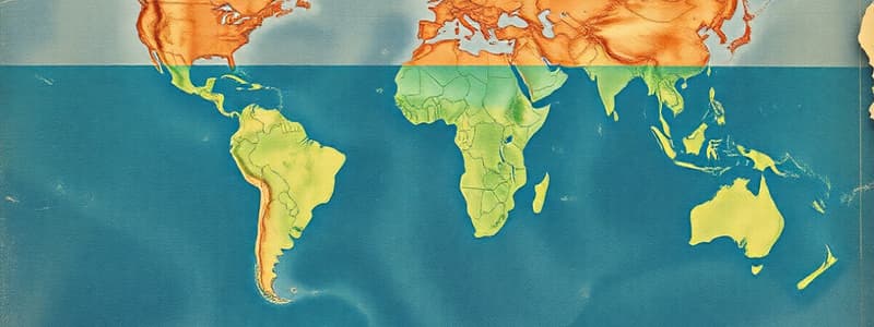
Oceans
- Oceans are saline and the oceans cover around 70% of Earth's surface.
- Average ocean depth is 3.8 km.
- The ocean "trenches" are the deepest parts, at around 11km.
- The major oceans are:
- Pacific
- Atlantic
- Indian
- Southern
- Arctic.
Pacific Ocean
- The Pacific Ocean is the largest and deepest ocean, covering 30% of the Earth's surface.
- Extends from Arctic Ocean to the Southern Ocean, bordered by Asia and Australia to the west, and America in the west.
- Contains volcanic islands and is triangular in shape.
Atlantic Ocean
- The Atlantic Ocean is the 2nd largest and busiest ocean; covering 20.8% of the Earth's surface.
- Shaped like the letter 'S' and contains lots of shallow seas.
- Natural harbors exist thanks to indented coastlines.
- The Mid-Atlantic Ridge is a large mountain range on the ocean floor.
Indian Ocean
- Most of the Indian Ocean is located in the southern hemisphere.
- Named after a country, and covers 14.4% of the Earth's surface.
- Important for it's high oil reserves; the Bay of Bengal and the Arabian Sea are northward sides of the Indian Ocean.
Antarctica and Artic Oceans
- The Antarctic/Southern Ocean surrounds Antarctica.
- Large ice sheets cover most this ocean.
- The Arctic Ocean is the world's smallest (2.8%) and is surrounded by numerous landmasses and marginal seas.
Ocean Water Circulation
- Ocean water is dynamic and moves continuously in vertical/horizontal directions.
- Dynamic movement owes itself to temperature/density differences, variations in salinity, and prevailing winds and manifests as waves, tides and currents.
Waves
- A wave is a regular rise and fall of ocean and sea water.
- The wind dictates the shape/size of waves.
- Crest - Upper wave
- Trough - Lower Wave
- Wave Height - Vertical distnace between crest and trough
- Wavelength - Horizontal distance between crests.
Waves, Earthquakes and Tsunamis
- The size of a wave depends of the wind, and may lead to destructions.
- Earthquakes displace large amounts of water, giving rise to "tidal waves," aka Tsunamis.
- A tsunami caused destruction along Japan's coasts, with the Fukushima nuclear power plant being the most serious.
- Economic losses from the Daiichi Nuclear Power Station exceeded $300B dollars.
Tsunamis
- Tsunami struck havoc in the Indian Ocean on Dec 26 2004 as a result of a magnitude 9.0 earthquake.
- The Indian plate moved under the Burma plate, causing the sea floor it displace (~10-20m) and forcing a mass of water to flow and fill the gap.
- Tsumanis can travel as fast as commercial aircraft (~800 km/hour).
- They reduce in speed as depth decreases from (~700-~900km/h to <70km/hr)
Tsunami Impacts
- Waves have been known to travel up to ~3km inland
- Killed >10,000 people.
- Affected more than 100,000 houses.
- Touched India's coasts, specifically Andhra Pradesh, Tamil Nadu, Kerala, Puducherry, the Andaman and Nicobar Islands.
Forecasting
- Earthquake cannot be predicted in advance, but ~3 hour warnings for tsunamis can be given.
- Early warming systems are in place around the Pacific Ocean, but not in the not in the Indian Ocean.
- Tsunamis are rare in the Indian Ocean due to low seismic activity.
Tsunamis Revisited
- The December 2004 tsunami was the most devastating tsunami in years.
- Damage was primarily due to lack of monitoring systems/knowledge in coastal regions.
- Tsunami means "harbor wave".
Tides
- Daily sea water rises and recedes causing Tides.
- These are caused by the Moon/Sun and the rotation of the Earth.
- The Moon exerts the greatest gravitational pull on the Earth.
- During full/new moons, the Earth, Moon and Sun are in a line causing high tides (spring tides).
- If the sun and moon are in opposites of eac other causing them to pull diagonally will causes low tides (neap tides).
Importance of Tides
- Tides clear mud and silt deposits.
- Immense help in shipping and navigation especially for large (spring) tides.
- Fish approach coasts during tides enabling bountiful catches.
- Tides is a source of renewable energy utilized in Canada, France, China, Russia, South Korea and Japan.
Ocean Currents
- The continuous movement/drift of ocean water (2 to 10 km per hour) aka ocean currents.
- Drifts are broad and slow-moving.
- Temperature distinguishes warm from cold ocean currents.
- Warm ones go from a warm place to a cold place and vice versa; cold ones go from the poles down to the equator region
- Winds, planetary rotation, tides, shape of landmasses contribute to ocean water circulation.
Coriolis Effects
- Coriolis effects influence oceanic current direction
- Clockwise in the northern regions.
- Anti clock wise in the southern hemisphere.
- Landmasses may obstruct ocean currents.
- The Gulf Stream/Brazil current divide when reaching South America.
General Winds
- Winds that pass over warm currents draw moisture while cold currents yield very little moisture.
- Heavy fog when mixing can cause hindrance to shipping.
- The mixing of water is ideal for plankton productivity (ex: the coast of Newfoundland, where the warm Gulf Stream meets the cold Labrador Current).
- Ships like to move faster and save on time/fuel by adhering to currents during travel.
Hydrosphere
- Hydrosphere has many importance for sustaining life
- Domestic water for lakes and rivers
- Facilitate transport and communication.
- Divers marine life and products.
- Provide salt and minerals.
- Influence weather and climate.
- Supports different processes (hydroelectricity via rivers).
- Because water is precious it is important to utilize and conserve it.
Studying That Suits You
Use AI to generate personalized quizzes and flashcards to suit your learning preferences.


