Podcast
Questions and Answers
What is the primary process described as the breaking down and changing of rocks due to environmental exposure?
What is the primary process described as the breaking down and changing of rocks due to environmental exposure?
- Erosion
- Deposition
- Weathering (correct)
- Transportation
Which process involves the transportation of sediments from one location to another?
Which process involves the transportation of sediments from one location to another?
- Erosion (correct)
- Weathering
- Sublimation
- Deposition
What is the outcome of the deposition process?
What is the outcome of the deposition process?
- Chemical alteration of rocks
- Breaking down of rocks
- Dropping off of sediments (correct)
- Transportation of sediments
Which type of weathering is characterized by physical changes without altering chemical composition?
Which type of weathering is characterized by physical changes without altering chemical composition?
What process involves water freezing in rock cracks and expanding to break the rock apart?
What process involves water freezing in rock cracks and expanding to break the rock apart?
What is frost action primarily responsible for?
What is frost action primarily responsible for?
Which process involves grinding one rock against another?
Which process involves grinding one rock against another?
What is oxidation primarily a cause of?
What is oxidation primarily a cause of?
Which factor is NOT a major influence the rate of weathering in a region?
Which factor is NOT a major influence the rate of weathering in a region?
What is the effect of glacial abrasion?
What is the effect of glacial abrasion?
Why are sinkholes formed?
Why are sinkholes formed?
Which weathering process involves temperature changes causing rock to peel away slowly?
Which weathering process involves temperature changes causing rock to peel away slowly?
What characteristic of older rivers contributes to their slow flow velocity?
What characteristic of older rivers contributes to their slow flow velocity?
What primarily occurs when a river flows faster?
What primarily occurs when a river flows faster?
How do higher flow velocities affect sediment size in rivers?
How do higher flow velocities affect sediment size in rivers?
Where does deposition occur in a meandering river?
Where does deposition occur in a meandering river?
What results when a river meander becomes cut off from the main flow?
What results when a river meander becomes cut off from the main flow?
What is the primary factor causing sediment deposition at the mouth of a river?
What is the primary factor causing sediment deposition at the mouth of a river?
How are sediments sorted when a river flows into a larger body of water?
How are sediments sorted when a river flows into a larger body of water?
What happens to sediment during the formation of a delta?
What happens to sediment during the formation of a delta?
Which of the following factors does NOT impact the velocity of a river?
Which of the following factors does NOT impact the velocity of a river?
In a river, where is the fastest water flow typically observed?
In a river, where is the fastest water flow typically observed?
How is a watershed defined?
How is a watershed defined?
What typically characterizes a young river system?
What typically characterizes a young river system?
What is the term for the lowest point of a river where it enters a larger body of water?
What is the term for the lowest point of a river where it enters a larger body of water?
What is a primary control of a rivers velocity that has to do with topography?
What is a primary control of a rivers velocity that has to do with topography?
What forms when a river slows down and deposits sediment due to flattening of the slope?
What forms when a river slows down and deposits sediment due to flattening of the slope?
What is the primary way that running water alters the Earth's surface?
What is the primary way that running water alters the Earth's surface?
What percentage of freshwater is found in rivers, streams, and creeks?
What percentage of freshwater is found in rivers, streams, and creeks?
What has caused the increase in frequency of 100-year precipitation events to occur approximately every seven to eight years?
What has caused the increase in frequency of 100-year precipitation events to occur approximately every seven to eight years?
How much more water can the air hold for each degree Celsius increase in temperature?
How much more water can the air hold for each degree Celsius increase in temperature?
What has been one of the primary reasons for the increase in flooding severity in certain neighborhoods in many cities (including New York)?
What has been one of the primary reasons for the increase in flooding severity in certain neighborhoods in many cities (including New York)?
Flashcards
Weathering
Weathering
The breakdown and changing of rocks due to exposure to the environment.
Erosion
Erosion
The transportation of weathered rock sediments from one place to another.
Deposition
Deposition
The process of depositing or dropping off weathered and eroded sediments.
Physical Weathering
Physical Weathering
Signup and view all the flashcards
Chemical Weathering
Chemical Weathering
Signup and view all the flashcards
Frost Action
Frost Action
Signup and view all the flashcards
Exfoliation
Exfoliation
Signup and view all the flashcards
Root Wedging
Root Wedging
Signup and view all the flashcards
Oxidation
Oxidation
Signup and view all the flashcards
Carbonation
Carbonation
Signup and view all the flashcards
Climate's Effect on Weathering
Climate's Effect on Weathering
Signup and view all the flashcards
Rock Hardness's Effect on Weathering
Rock Hardness's Effect on Weathering
Signup and view all the flashcards
Meander
Meander
Signup and view all the flashcards
Stream banks
Stream banks
Signup and view all the flashcards
Stream bed
Stream bed
Signup and view all the flashcards
Tributary
Tributary
Signup and view all the flashcards
Watershed
Watershed
Signup and view all the flashcards
River Meander Erosion & Deposition
River Meander Erosion & Deposition
Signup and view all the flashcards
River Velocity & Sediment Transport
River Velocity & Sediment Transport
Signup and view all the flashcards
River Deposition
River Deposition
Signup and view all the flashcards
River Erosion
River Erosion
Signup and view all the flashcards
River Meandering
River Meandering
Signup and view all the flashcards
What is a meander?
What is a meander?
Signup and view all the flashcards
Where does deposition occur in a meander?
Where does deposition occur in a meander?
Signup and view all the flashcards
What is an oxbow lake?
What is an oxbow lake?
Signup and view all the flashcards
What is a delta?
What is a delta?
Signup and view all the flashcards
Hydrologic Cycle
Hydrologic Cycle
Signup and view all the flashcards
Sun's Energy
Sun's Energy
Signup and view all the flashcards
Precipitation
Precipitation
Signup and view all the flashcards
Runoff
Runoff
Signup and view all the flashcards
Groundwater
Groundwater
Signup and view all the flashcards
Base Level
Base Level
Signup and view all the flashcards
Discharge
Discharge
Signup and view all the flashcards
Competence
Competence
Signup and view all the flashcards
Capacity
Capacity
Signup and view all the flashcards
Alluvium
Alluvium
Signup and view all the flashcards
Warmer Atmosphere = More Moisture
Warmer Atmosphere = More Moisture
Signup and view all the flashcards
100-Year Floods are Now More Frequent
100-Year Floods are Now More Frequent
Signup and view all the flashcards
Impervious Surfaces and Flooding
Impervious Surfaces and Flooding
Signup and view all the flashcards
Changing Rainfall Patterns
Changing Rainfall Patterns
Signup and view all the flashcards
Climate Change & Flooding
Climate Change & Flooding
Signup and view all the flashcards
Outdated Flood Risk Assessment
Outdated Flood Risk Assessment
Signup and view all the flashcards
Extreme Precipitation Approach
Extreme Precipitation Approach
Signup and view all the flashcards
Rain Garden
Rain Garden
Signup and view all the flashcards
Climate Resilience
Climate Resilience
Signup and view all the flashcards
Green Space
Green Space
Signup and view all the flashcards
Study Notes
Weathering, Erosion, and Deposition
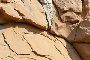
- Weathering: Breaking down and changing rocks due to environmental exposure. Environmental forces like air, wind, water, and ice break rocks down into smaller pieces called sediments. In some cases, weathering can change the composition of the rock.
Types of Weathering
-
Physical/Mechanical Weathering: Breaking, cracking, and grinding rocks without changing their composition (e.g., size and shape change). Key examples:
- Frost Action (Ice Wedging): Water seeps into cracks, freezes and expands, forcing rocks apart.
- Exfoliation: Dramatic temperature changes cause rocks to expand and contract, creating cracks and peeling.
- Abrasion: Rocks grinding against each other (wind, water, glaciers). Sand bouncing against rocks in a river is a form of mechanical abrasion and rounds the rocks.
- Root Wedging: Plant roots grow into cracks, causing rocks to break apart.
-
Chemical Weathering: Changing rock composition through reactions with substances like air or water. Key examples:
- Oxidation: Iron in rocks reacts with oxygen (rust), breaking the rocks down.
- Carbonation: Water reacting with soil particles to create carbonic acid, which dissolves rocks like limestone, creating caves and sinkholes.
Erosion
- Transportation of weathered sediments from one place to another. Examples include sediments being carried by moving water in a river.
Deposition
- Dropping off of weathered and eroded sediments. Examples include sediments piling up on a coastline, or in a delta as water slows.
Factors Affecting Weathering
- Climate:
- Temperature and moisture influence weathering rates.
- Hot and dry climates generally have less weathering, while hot and wet climates have more chemical weathering.
- Cold climates with temperature fluctuations experience more frost action.
- Hardness of Rock: Harder rocks weather more slowly than softer rocks.
- Surface Area: More exposed surface area leads to faster weathering.
- Increased Rainfall Intensity: Warmer temperatures increase atmospheric moisture leading to more intense precipitation events, which affects weathering and erosion. This is changing the severity and frequency of floods.
Rivers
-
River Definition: Water flowing downhill through a channel or defined pathway. Streams, creeks, and brooks can be considered smaller rivers.
-
River Anatomy:
- Meanders: Curves or bends in a river; Sites of significant erosion and deposition along the river banks.
- Banks: Sides of the river channel.
- Bed: Bottom of the river channel.
- Tributary: Smaller stream flowing into a larger stream or river.
- River System: A network of tributaries feeding into a main river.
- Watershed (Drainage Basin): An entire region of land where all water (including groundwater) flows into a single water body (river, lake, ocean).
-
River Velocity:
- Discharge: The volume of water flowing in a stream; higher discharge leads to faster flow. Discharge is significantly impacted by rainfall and snowmelt and more intense precipitation events.
- Slope: Steeper slopes result in faster flow due to gravity.
- Channel Shape: Narrower, V-shaped channels have faster flow (less friction). Wider, flatter channels have slower flow (more friction). Fastest velocity occurs in the center, away from the riverbed.
-
River Age:
- Young Rivers: Steeper slopes, deeper/narrower channels, faster flow, less deposition and more erosion.
- Older Rivers: Graded slopes - flattened, shallow/wider channels, slower flow, increased deposition with large meanders.
-
Sediment Transport:
- Sediment Size and Velocity: Faster rivers transport larger sediments (sand, pebbles, cobbles, rocks). Slower rivers carry smaller sediments (silt, clay).
- Sediment Types: Based on river velocity: Suspended sediments (clay, silt) carried in the water, bedload sediments (sand, gravel) bouncing along the river bottom.
- Discharge: Important in determining capacity and competence.
- Capacity: Maximum sediment load a river can carry; higher discharge means higher capacity.
- Competence: Maximum grain size a river can carry; higher velocity means higher competence.
-
Erosion and Deposition in Meanders:
- Erosion: Outside of the curves where water is faster.
- Deposition: Inside of the curves where water is slower.
-
Oxbow Lakes: Form when meanders become increasingly wide and the river cuts a new channel, leaving a U-shaped lake. This is due to continuous erosion and deposition.
-
Delta Formation: Sediment deposition where a river enters a larger body of water (lake or ocean); The sediment is sorted by size (horizontally) with larger materials first. Vertical sorting (graded bedding) can also occur if sediments accumulate rapidly.
-
Abrasion: Rocks grinding against each other in the river, resulting in rounded rocks.
-
Hydraulic pressure: Pressure exerted by water on rock surfaces contributing to weathering and erosion. Sediments from the bedload also cause abrasion.
-
Floodplains: Flat areas adjacent to rivers; deposition of sediments happens here during floods. Levee structures can form here.
-
Levees: Structures of sediment along the river banks, created during floods.
-
Alluvial fans: Formed when rivers carry sediments to flat areas and velocity decreases, causing larger sediment deposit.
-
Braided rivers: Formed by splitting of waters through a bed of sediment.
-
Waterfalls: Form from resistant rock layers being selectively eroded; undercutting can cause the top layer to collapse.
-
Channel shape and friction:
- Channel shape affects the friction the water experiences.
- Narrow or shallow channels lead to increased friction.
- Deep and wide channels have less friction, leading to a higher velocity.
- Boulders and rough surfaces increase friction, while smooth surfaces decrease it.
-
Discharge and velocity: Discharge is the volume of water flowing, and velocity is related to discharge; higher discharge results in higher velocity.
-
Dams and sediment deposition: Dams disrupt river flow, and the deposited sediment can affect lake levels. The water released from dams flows at high velocity, causing erosion downstream.
-
Flood events: Rivers flood when more water than the channel can contain enters it, resulting in the water overtopping its banks and deposition. Increased precipitation intensity contributes to more frequent and severe floods.
-
Oxbow lakes: During a flood the river may cut across a meander and form a new path leaving the old meandering section as an oxbow lake.
-
Impact of human alteration on rivers: Modifications such as agricultural and urban development can affect runoff and raise river discharge leading to more frequent severe floods. Urbanization and the replacement of natural surfaces with impermeable materials (concrete, asphalt) increase runoff and flood risk.
-
Hydrologic (water) cycle: Continuous movement of water between various reservoirs on Earth; a crucial aspect of river and sediment dynamics. Evaporation drives the atmosphere, impacting precipitation and subsequent river flows. Changing temperatures significantly affect the rate of evaporation, leading to wetter wet seasons and drier dry seasons.
-
Urbanization's impact: Urbanization with impermeable surfaces increases runoff and flood risk. Existing infrastructure is not adapted to the accelerated changes in precipitation.
-
Outdated Flood Risk Maps: Existing flood risk maps (e.g., NOAA's) rely on historical data, which underestimates the increasing risks from more intense precipitation events. These maps fail to predict changes to the hydrologic cycle, the increased frequency of extreme precipitation, and the current risk levels.
-
First Street risk maps: First Street created a new risk map with a more forward-looking approach, focusing on extreme precipitation events and the increased likelihood of flooding. This map better reflects contemporary risk levels.
-
Wealth and race disparity in flood recovery: Studies show significant wealth discrepancies in disaster recovery, with communities of color experiencing adverse effects compared to white communities.
-
Flood protection measures: Examples include flood mitigation projects, installing green infrastructure (rain gardens), and sewer systems that use water retention systems.
Studying That Suits You
Use AI to generate personalized quizzes and flashcards to suit your learning preferences.