Podcast
Questions and Answers
Compare the plate boundary settings of Anak Krakatau and Eyjafjallajökull, detailing the plate movements involved and their influence on the type of volcanism observed.
Compare the plate boundary settings of Anak Krakatau and Eyjafjallajökull, detailing the plate movements involved and their influence on the type of volcanism observed.
Anak Krakatau is at a convergent boundary where the Eurasian, Philippine, and Pacific plates interact, leading to explosive volcanism. Eyjafjallajökull is at a divergent boundary between the Eurasian and North American plates, resulting in more effusive volcanism.
Explain how the differing literacy rates in Indonesia and Iceland (as exemplified by the case studies of Anak Krakatau and Eyjafjallajökull) influenced the effectiveness of evacuation and emergency response during their respective volcanic events.
Explain how the differing literacy rates in Indonesia and Iceland (as exemplified by the case studies of Anak Krakatau and Eyjafjallajökull) influenced the effectiveness of evacuation and emergency response during their respective volcanic events.
Iceland's higher literacy rate (100%) allowed for better dissemination and understanding of warnings, while Indonesia's lower rate (95%) may have hindered communication and evacuation efforts.
Discuss how the population density around Anak Krakatau compared to Eyjafjallajökull affected the scale and nature of social impacts (fatalities, injuries, displacement) following their respective eruptions.
Discuss how the population density around Anak Krakatau compared to Eyjafjallajökull affected the scale and nature of social impacts (fatalities, injuries, displacement) following their respective eruptions.
Anak Krakatau had a high coastal population density, leading to significant fatalities and injuries from the tsunami. Eyjafjallajökull had a low population density of farmers, resulting in fewer direct casualties but significant agricultural disruption.
Explain how the non-operational tsunami warning system near Anak Krakatau, contrasted with the seismic and GPS monitoring systems in Iceland, affected the immediate response to the volcanic eruption and subsequent hazards.
Explain how the non-operational tsunami warning system near Anak Krakatau, contrasted with the seismic and GPS monitoring systems in Iceland, affected the immediate response to the volcanic eruption and subsequent hazards.
Contrast the short-term economic impacts of the Eyjafjallajökull eruption on European air travel with the impacts of the Anak Krakatau eruption on coastal fishing and tourism facilities in Indonesia.
Contrast the short-term economic impacts of the Eyjafjallajökull eruption on European air travel with the impacts of the Anak Krakatau eruption on coastal fishing and tourism facilities in Indonesia.
Explain how the contrasting levels of healthcare access in Nepal and New Zealand influenced the management of injuries and rehabilitation efforts following the 2015 Nepal and 2016 New Zealand earthquakes, respectively.
Explain how the contrasting levels of healthcare access in Nepal and New Zealand influenced the management of injuries and rehabilitation efforts following the 2015 Nepal and 2016 New Zealand earthquakes, respectively.
Describe how the enforcement (or lack thereof) of building codes in Nepal and New Zealand contributed to the differences in infrastructure damage and fatalities from the 2015 Nepal and 2016 New Zealand earthquakes.
Describe how the enforcement (or lack thereof) of building codes in Nepal and New Zealand contributed to the differences in infrastructure damage and fatalities from the 2015 Nepal and 2016 New Zealand earthquakes.
Discuss how the disruption of transportation routes (roads, railways) following the Nepal and New Zealand earthquakes affected the delivery of aid and emergency supplies to affected populations.
Discuss how the disruption of transportation routes (roads, railways) following the Nepal and New Zealand earthquakes affected the delivery of aid and emergency supplies to affected populations.
Explain how the differing economic capacities of Nepal and New Zealand influenced their ability to fund reconstruction efforts and provide long-term support to affected communities after the earthquakes.
Explain how the differing economic capacities of Nepal and New Zealand influenced their ability to fund reconstruction efforts and provide long-term support to affected communities after the earthquakes.
Compare the immediate relief responses in Nepal and New Zealand after their earthquakes, focusing on the roles played by the military, international aid organizations, and local communities.
Compare the immediate relief responses in Nepal and New Zealand after their earthquakes, focusing on the roles played by the military, international aid organizations, and local communities.
Explain how the slow-moving nature of the Ponzano landslide in Italy, compared to the rapid onset of the Freetown mudflows in Sierra Leone, affected the ability of authorities to evacuate residents and minimize fatalities.
Explain how the slow-moving nature of the Ponzano landslide in Italy, compared to the rapid onset of the Freetown mudflows in Sierra Leone, affected the ability of authorities to evacuate residents and minimize fatalities.
Describe how deforestation in Sierra Leone might have contributed to the severity of the Freetown mudflows, contrasting this with the causes of the Ponzano landslide in Italy.
Describe how deforestation in Sierra Leone might have contributed to the severity of the Freetown mudflows, contrasting this with the causes of the Ponzano landslide in Italy.
Compare the access to healthcare professionals in Ponzano, Italy, and Freetown, Sierra Leone, and explain how this difference influenced the capacity to respond to the health needs of affected populations after their respective mass movement events.
Compare the access to healthcare professionals in Ponzano, Italy, and Freetown, Sierra Leone, and explain how this difference influenced the capacity to respond to the health needs of affected populations after their respective mass movement events.
Explain how the topography and climate of Freetown, Sierra Leone, made it particularly vulnerable to the mudflows that occurred in August 2017, in contrast to the geographical context of the Ponzano landslide in Italy.
Explain how the topography and climate of Freetown, Sierra Leone, made it particularly vulnerable to the mudflows that occurred in August 2017, in contrast to the geographical context of the Ponzano landslide in Italy.
Discuss how the economic impacts of the Freetown mudflows extended beyond immediate property damage to affect long-term agricultural productivity, contrasting this with the economic impacts of the Ponzano landslide.
Discuss how the economic impacts of the Freetown mudflows extended beyond immediate property damage to affect long-term agricultural productivity, contrasting this with the economic impacts of the Ponzano landslide.
Describe how the evacuation procedures differed between the Ponzano landslide and the Freetown mudflow events, and how these differences affected the outcomes in terms of lives saved and property damage.
Describe how the evacuation procedures differed between the Ponzano landslide and the Freetown mudflow events, and how these differences affected the outcomes in terms of lives saved and property damage.
Explain how the monitoring and tracking conducted by the Civil Protection Department in Italy contributed to the effective response to the Ponzano landslide, contrasting this with the situation in Freetown prior to the mudflows.
Explain how the monitoring and tracking conducted by the Civil Protection Department in Italy contributed to the effective response to the Ponzano landslide, contrasting this with the situation in Freetown prior to the mudflows.
Compare the provision of aid and support to affected residents following the Ponzano landslide and the Freetown mudflows, considering the roles of local authorities, international organizations, and neighboring countries.
Compare the provision of aid and support to affected residents following the Ponzano landslide and the Freetown mudflows, considering the roles of local authorities, international organizations, and neighboring countries.
Explain how the contrasting levels of economic development in Italy and Sierra Leone influenced the availability of resources and technology for responding to and recovering from their respective mass movement events.
Explain how the contrasting levels of economic development in Italy and Sierra Leone influenced the availability of resources and technology for responding to and recovering from their respective mass movement events.
Discuss the potential for pollution of water sources following the Freetown mudflows due to the mixing of mud and sewage, and how this risk compared to the environmental impacts associated with the Ponzano landslide.
Discuss the potential for pollution of water sources following the Freetown mudflows due to the mixing of mud and sewage, and how this risk compared to the environmental impacts associated with the Ponzano landslide.
Evaluate how the presence or absence of robust building codes in Nepal and New Zealand influenced infrastructure resilience during the 2015 Nepal earthquake and the 2016 Kaikoura earthquake, respectively.
Evaluate how the presence or absence of robust building codes in Nepal and New Zealand influenced infrastructure resilience during the 2015 Nepal earthquake and the 2016 Kaikoura earthquake, respectively.
Discuss the role of land use planning in mitigating the risks associated with mass movement events, contrasting the approaches taken in Ponzano, Italy, and Freetown, Sierra Leone.
Discuss the role of land use planning in mitigating the risks associated with mass movement events, contrasting the approaches taken in Ponzano, Italy, and Freetown, Sierra Leone.
How did the disruption of coastal breeding areas for dolphins and seals in New Zealand, following the Kaikoura earthquake, affect the local ecosystem?
How did the disruption of coastal breeding areas for dolphins and seals in New Zealand, following the Kaikoura earthquake, affect the local ecosystem?
What secondary hazard impacted Mt. Everest after the 2015 Nepal earthquake, and what were its consequences?
What secondary hazard impacted Mt. Everest after the 2015 Nepal earthquake, and what were its consequences?
Describe how the difference in river management strategies affected the extent of flooding after the melting of ice caps during the eruption of Eyjafjallajökull.
Describe how the difference in river management strategies affected the extent of flooding after the melting of ice caps during the eruption of Eyjafjallajökull.
Flashcards
Anak Krakatau
Anak Krakatau
A volcano formed from the 1883 Krakatoa eruption in Indonesia.
Anak Krakatau Type
Anak Krakatau Type
An explosive composite stratovolcano located in Indonesia within the Pacific Ring of Fire, characterized by its significant explosive eruptions.
Eyjafjallajökull
Eyjafjallajökull
A volcano in Iceland that caused air travel disruption in 2010.
Eyjafjallajökull Type
Eyjafjallajökull Type
Signup and view all the flashcards
Volcanic Explosivity Index (VEI)
Volcanic Explosivity Index (VEI)
Signup and view all the flashcards
Anak Krakatau Collapse (2018)
Anak Krakatau Collapse (2018)
Signup and view all the flashcards
Eyjafjallajökull Initial Eruption
Eyjafjallajökull Initial Eruption
Signup and view all the flashcards
Eyjafjallajökull 2nd Phase
Eyjafjallajökull 2nd Phase
Signup and view all the flashcards
Anak Krakatau Social Impact
Anak Krakatau Social Impact
Signup and view all the flashcards
Eyjafjallajökull Social Impact
Eyjafjallajökull Social Impact
Signup and view all the flashcards
Anak Krakatau Infrastructure Impact
Anak Krakatau Infrastructure Impact
Signup and view all the flashcards
Eyjafjallajökull Transportation Impact
Eyjafjallajökull Transportation Impact
Signup and view all the flashcards
Anak Krakatau Agricultural Impact
Anak Krakatau Agricultural Impact
Signup and view all the flashcards
Eyjafjallajökull Agricultural Impact
Eyjafjallajökull Agricultural Impact
Signup and view all the flashcards
Anak Krakatau Warning System
Anak Krakatau Warning System
Signup and view all the flashcards
Iceland's Resilience
Iceland's Resilience
Signup and view all the flashcards
Nepal Earthquake Secondary Hazard
Nepal Earthquake Secondary Hazard
Signup and view all the flashcards
New Zealand Earthquake Secondary Hazard
New Zealand Earthquake Secondary Hazard
Signup and view all the flashcards
Nepal Earthquake Social Impact
Nepal Earthquake Social Impact
Signup and view all the flashcards
New Zealand Earthquake Social Impact
New Zealand Earthquake Social Impact
Signup and view all the flashcards
Ponzano Landslide Economical Impact
Ponzano Landslide Economical Impact
Signup and view all the flashcards
Freetown Mudflows Economical Impact
Freetown Mudflows Economical Impact
Signup and view all the flashcards
Ponzano Landslide Relief
Ponzano Landslide Relief
Signup and view all the flashcards
Freetown Mudflows Relief
Freetown Mudflows Relief
Signup and view all the flashcards
Freetown Healthcare Aid
Freetown Healthcare Aid
Signup and view all the flashcards
Study Notes
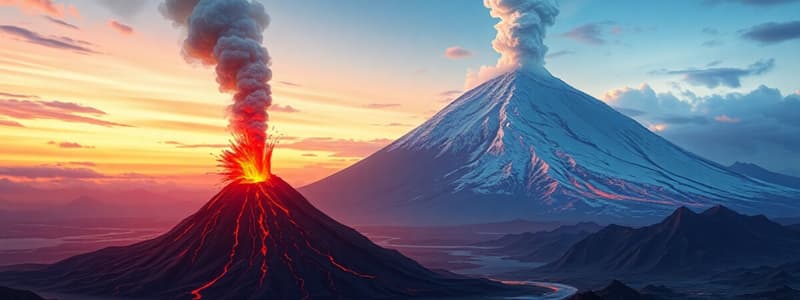
Volcanoes: Anak Krakatau vs. Eyjafjallajökull
- Anak Krakatau is located in Indonesia within the Pacific Ring of Fire.
- Eyjafjallajökull is located in Iceland.
- Both volcanoes registered a VEI (Volcanic Explosivity Index) of 3-4, classifying them as medium-sized eruptions.
- Anak Krakatau is situated at a convergent plate boundary involving the Eurasian, Philippine, and Pacific plates.
- Eyjafjallajökull sits on a divergent plate boundary between the Eurasian and North American plates.
- Anak Krakatau is an explosive composite stratovolcano.
- Eyjafjallajökull is an effusive shield volcano.
- Anak Krakatau erupted on December 22, 2018.
- Eyjafjallajökull erupted in March 2010.
Anak Krakatau Eruption and Impacts
- Anak Krakatau, meaning "Child of Krakatoa," formed after the 1883 Krakatoa eruption.
- A sector of the volcano collapsed, triggering a tsunami.
- The tsunami struck nearby coastlines, causing almost 500 deaths and injuring 15,000.
- Over 600 homes and 60 shops were impacted.
- Coastal fishing and tourism facilities suffered.
- Roads and bridges were inundated.
- Land was flooded with salt water, harming sea turtles.
- A non-operational tsunami warning buoy system, due to vandalism, limited budget, and technical issues, worsened the impact.
- The literacy rate in the affected area was 95%.
- The high coastal population density increased the impact.
- The tsunami struck at night without warning.
- There was limited budget to respond and poor evacuation measures.
- Limited healthcare, with 0.02 doctors per 1000 people, further complicated the relief efforts.
Eyjafjallajökull Eruption and Impacts
- In March 2010, magma broke through the crust, ejecting lava and ash.
- A second eruptive phase occurred on April 14, 2010, under an icecap.
- The eruption melted a large amount of ice, causing river levels to rise and water temperatures to reach 17°C.
- Molten lava combined with water, creating explosive vapor bubbles and glass-rich ash plumes propelled into the jet stream.
- Later, cracks detected raised fears of a second tsunami and an eruption of Katla, Iceland’s most destructive volcano.
- No fatalities occurred.
- The eruption significantly impacted tourism.
- Grounded flights (95,000) disrupted import of supplies and tourist flows in Northern and Central Europe.
- Ashfall of 5cm on farms made it difficult to farm and harvest.
- The eruption temporarily increased albedo.
- A flash flood event raised temperatures by 6°C in 2 hours, up to 17°C, damaging river channels and banks.
- Ash fertilized some areas.
- The literacy rate was 100%.
- Low population density among farmers (500 evacuated) reduced the impact.
- Iceland is tectonically active.
- Iceland has ash-resistant buildings.
- Iceland has 80 seismic stations and 120 GPS stations.
- Iceland has high resilience and capacity to respond, with 1.2 doctors per 1000 people.
- Reconstruction involved building solid houses, repairing old buildings, and preparing for ashfall.
Earthquakes: Nepal vs. New Zealand
- The Nepal earthquake occurred in a landlocked country between China and India, in the Himalayas.
- The New Zealand earthquake occurred southeast of Australia.
- Both earthquakes registered a magnitude of 7.8.
- Nepal is one of the poorest countries, while New Zealand is one of the wealthiest.
- The Nepal earthquake occurred at a convergent plate boundary between the Indian and Eurasian plates.
- The New Zealand earthquake occurred at a convergent plate boundary involving the Indian, Pacific, and Australian plates.
- The Nepal earthquake's epicenter was 80km NW of Kathmandu in the Gorka district.
- The New Zealand earthquake's epicenter was 15km NE of Culverden.
- Both earthquakes had a shallow focus of 15km beneath the surface.
- The Nepal earthquake had over 300 aftershocks.
- The New Zealand earthquake had an aftershock on November 17th of 2000.
- The Nepal earthquake occurred in April 2015.
- The New Zealand earthquake occurred in November 2016.
Nepal Earthquake and Impacts
- The Nepal earthquake triggered an avalanche on Mount Everest, killing 20 people, and a large avalanche in the Langtang valley, killing 250.
- The earthquake caused 9000 deaths and over 20,000 injuries.
- It left 3.5 million people homeless.
- 7000 schools and 1000 health facilities were destroyed.
- Offices, shops, and factories were damaged.
- Loss of income and tourism occurred
- Landslides blocked roads and rivers.
- 390 km of road/railway were destroyed.
- Communities were cut off for 16 days.
- Damage was estimated at $7-10b (35% of GDP).
- Avalanches occurred on Mount Everest.
- UNESCO world heritage sites and temples got destroyed
- Almost 11,000 landslides occurred.
- There was a lack of education and communication regarding earthquake risks.
- 80% of the population lived in rural areas.
- $3 billion in aid was donated.
- Helicopters and ships provided emergency supplies and evacuated people.
- Short- to mid-term responses included temporary shelters, medical staff, and mobilization of 90% of the Nepalese army.
- Long-term reconstruction involved clearing landslides, repairing roads, rebuilding schools, introducing earthquake drills, and stricter building codes.
New Zealand Earthquake and Impacts
- The New Zealand earthquake triggered a landslide that blocked the Clarence River, causing flooding.
- The earthquake triggered a 5m tsunami, leaving debris up to 250 meters inland.
- There were 2 deaths and +50 injuries.
- 60 people were temporarily made homeless.
- Over 2000 buildings were impacted.
- Water, power, and telecommunications were cut off.
- $2.27b was the insurance cost.
- $3.5b was the cost to the government.
- The coastline uplifted by 5.5m.
- There were disruptions of coastal breeding areas for dolphins and seals.
- Boats couldn't leave/enter harbor.
- Tsunami warnings were issued via sirens, texts, and social media.
- Emergency supplies were provided.
- Search and rescue teams were dispatched.
- Power was restored within hours, and a mail route was open after 2 months.
- The harbor was repaired after over a year.
Mass Movement: Ponzano Landslide, Italy vs. Freetown, Sierra Leone
- The Ponzano landslide occurred in a village northeast of Italy, about 30 km north of Venice.
- The Freetown mudflows occurred in the capital and largest city of Sierra Leone.
- The Ponzano landslide was a slow-moving landslide, averaging 1 meter/day for 2 weeks.
- The Freetown mudflows were rapid-onset following three days of torrential rainfall.
- The Ponzano landslide occurred on February 12, 2017.
- The Freetown mudflows occurred on August 14, 2017.
Ponzano Landslide Causes and Impacts
- Saturated soil caused the Ponzano landslide.
- Snowmelt of 2 meters of snow and intense rainfall (81mm in four days) were attributed to the saturated soil.
- Due to the slow movement of the landside losses were minimized.
- Limited damage occurred due to the area's small population.
- 100 people were evacuated from 35 houses by authorities.
- Residents were evacuated to local hotels/friends/family.
- Firefighters were in place to help villagers recover belongings.
- Local health authority teams were set up with psychologists
- Not possible to stop the landslide.
- Evacuated buildings had property recovered.
Freetown Mudflows Causes and Impacts
- Unrestricted deforestation and construction of large hillside homes caused the Freetown mudflows.
- 1141 people died or are still missing.
- Hundreds of homes were damaged, displacing families and communities.
- 3000 people were left homeless and moved to emergency camps.
- UNICEF provided 26,000 liters of drinking water daily due to shortages, combined with the risk of cholera due to unsanitary water conditions.
- Damage to communication routes (roads, bridges, and footpaths) was valued at $1 million.
- Transportation and trade between communities was disrupted.
- Long-term economic losses occurred due to reduced agricultural productivity.
- An estimated 7 million m3 of material moved.
- Pollution of surface water occurred mud and sewage, creating unsanitary conditions and disease risks.
- Agricultural land became unsafe to cultivate.
- World Food Programme provided rations for 7,500 people.
- The EU gave €300,000 for humanitarian aid.
- Aid workers provided storage tanks, purification tablets, and instructional courses on hygiene.
Studying That Suits You
Use AI to generate personalized quizzes and flashcards to suit your learning preferences.
Description
A comparison of Anak Krakatau and Eyjafjallajökull volcanoes, highlighting their locations, VEI, and plate boundaries. Anak Krakatau is an explosive composite stratovolcano, while Eyjafjallajökull is an effusive shield volcano. The Anak Krakatau eruption caused a tsunami, leading to significant casualties and damage.


