Podcast
Questions and Answers
Which of the following statements accurately reflects the population distribution across the continents?
Which of the following statements accurately reflects the population distribution across the continents?
- Africa is the most populous continent.
- Australia and Oceania combined have the second largest population.
- Europe has a larger population than North America.
- Asia is the largest and most populous continent. (correct)
The Prime Meridian is also known as the Greenwich meridian and is located at 180° longitude.
The Prime Meridian is also known as the Greenwich meridian and is located at 180° longitude.
False (B)
Which of the following conditions is characteristic of Antarctica?
Which of the following conditions is characteristic of Antarctica?
- Located primarily in tropical latitudes.
- Supports dense forests and diverse wildlife populations.
- Has extreme climatic conditions. (correct)
- Known for mild, temperate climates and fertile soils.
What feature joins North and South America?
What feature joins North and South America?
_____ is the solar time at the Royal Observatory in Greenwich, London.
_____ is the solar time at the Royal Observatory in Greenwich, London.
Match each continent with its respective characteristic:
Match each continent with its respective characteristic:
Which of the following continents is also known as Eurasia's westernmost peninsula?
Which of the following continents is also known as Eurasia's westernmost peninsula?
Longitude measures the distance north or south of the Prime Meridian.
Longitude measures the distance north or south of the Prime Meridian.
The International Date Line primarily follows which meridian?
The International Date Line primarily follows which meridian?
What percentage of the Earth's total land area is covered by Asia?
What percentage of the Earth's total land area is covered by Asia?
The continent of ________ is the 3rd largest continent.
The continent of ________ is the 3rd largest continent.
Match the ocean to the continent to which it is adjacent:
Match the ocean to the continent to which it is adjacent:
Among the following, which best defines the role of the Equator?
Among the following, which best defines the role of the Equator?
Time zones are based on 30° longitude wide zones, ensuring uniform time across each zone.
Time zones are based on 30° longitude wide zones, ensuring uniform time across each zone.
Which of the following best describes the spatial relationship between Asia and Europe?
Which of the following best describes the spatial relationship between Asia and Europe?
What percentage of the total surface of Earth is covered by Asia?
What percentage of the total surface of Earth is covered by Asia?
The continent surrounded by the Atlantic Ocean, Pacific Ocean, and Caribbean Sea is ________.
The continent surrounded by the Atlantic Ocean, Pacific Ocean, and Caribbean Sea is ________.
Match the following terms with their corresponding locations or definitions:
Match the following terms with their corresponding locations or definitions:
Which of the following best describes the primary significance of the Global Culture and Tourism Geography course?
Which of the following best describes the primary significance of the Global Culture and Tourism Geography course?
GMT designates epochs to help interpret scientific data only.
GMT designates epochs to help interpret scientific data only.
Which best describes the composition of Australia and Oceania?
Which best describes the composition of Australia and Oceania?
Which ocean mainly surrounds Australia and Oceania?
Which ocean mainly surrounds Australia and Oceania?
Africa is the ________ largest continent.
Africa is the ________ largest continent.
Match the type of boundary to the body of water that forms it:
Match the type of boundary to the body of water that forms it:
Which factor most directly contributes to the unique characteristic of a 'time zone'?
Which factor most directly contributes to the unique characteristic of a 'time zone'?
The 'globe' represents a distorted view of Earth's surface.
The 'globe' represents a distorted view of Earth's surface.
Which of the following oceans does NOT border Asia?
Which of the following oceans does NOT border Asia?
Which continent is known for having more than 7,000 islands?
Which continent is known for having more than 7,000 islands?
Asia is divided into ________ sub-regions.
Asia is divided into ________ sub-regions.
Match the following subregions to their country:
Match the following subregions to their country:
Which of the following water formations is NOT located along the borders of Asia?
Which of the following water formations is NOT located along the borders of Asia?
Africa is the most populous continent.
Africa is the most populous continent.
Which continent's outline is most defined by its position as the southernmost landmass?
Which continent's outline is most defined by its position as the southernmost landmass?
Which continent forms part of the same landmass as Europe?
Which continent forms part of the same landmass as Europe?
___________ connect places with differing local times.
___________ connect places with differing local times.
Flashcards
Course Learning Outcome 1
Course Learning Outcome 1
Encompasses global culture and tourism geography, nature, scope, issues, and challenges.
Course Learning Outcome 2
Course Learning Outcome 2
Differentiates and classifies political structures, cultural, historical, religious, & educational aspects of tourist attractions.
Course Learning Outcome 3
Course Learning Outcome 3
Differentiates and distinguishes countries' languages, festivals, cuisines, and tourist attractions.
Course Learning Outcome 4
Course Learning Outcome 4
Signup and view all the flashcards
Asia
Asia
Signup and view all the flashcards
Asia's coverage
Asia's coverage
Signup and view all the flashcards
Central Asia
Central Asia
Signup and view all the flashcards
Eastern Asia
Eastern Asia
Signup and view all the flashcards
Southeastern Asia
Southeastern Asia
Signup and view all the flashcards
Southern Asia
Southern Asia
Signup and view all the flashcards
Western Asia (Middle East)
Western Asia (Middle East)
Signup and view all the flashcards
Africa
Africa
Signup and view all the flashcards
Africa's borders
Africa's borders
Signup and view all the flashcards
North America
North America
Signup and view all the flashcards
North America regions
North America regions
Signup and view all the flashcards
North America borders
North America borders
Signup and view all the flashcards
North America's islands
North America's islands
Signup and view all the flashcards
South America
South America
Signup and view all the flashcards
South American Countries
South American Countries
Signup and view all the flashcards
South America water borders
South America water borders
Signup and view all the flashcards
Europe
Europe
Signup and view all the flashcards
Europe's borders
Europe's borders
Signup and view all the flashcards
Regions of Europe
Regions of Europe
Signup and view all the flashcards
Western Europe countries
Western Europe countries
Signup and view all the flashcards
Southern European Countries
Southern European Countries
Signup and view all the flashcards
Eastern Europe countries
Eastern Europe countries
Signup and view all the flashcards
NW countries
NW countries
Signup and view all the flashcards
Australia and Oceania
Australia and Oceania
Signup and view all the flashcards
What Australia and Oceania composed of?
What Australia and Oceania composed of?
Signup and view all the flashcards
Antarctica
Antarctica
Signup and view all the flashcards
Globe
Globe
Signup and view all the flashcards
Earth
Earth
Signup and view all the flashcards
Longitude
Longitude
Signup and view all the flashcards
Latitude
Latitude
Signup and view all the flashcards
Equator
Equator
Signup and view all the flashcards
International Date Line
International Date Line
Signup and view all the flashcards
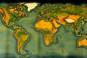
Study Notes
- The topic is an overview of the seven continents of the world
Course Learning Outcomes
- Students will be able to define and describe global culture and tourism geography, including its nature, scope, issues, and challenges
- Students will be able to differentiate and classify a country's political, cultural, historical, religious, and educational aspects where tourist attractions exist
- Students will be able to differentiate and distinguish countries' languages, festivals, cuisines, and tourist attractions, understanding cultural differences in major tourism destinations
- Students will be able to compare and examine selected countries, major travel destinations, entry points, and geographical features using mapping and familiarization
Asia
- Largest and most populous continent
- More than half of the world's population resides in Asia
- It covers 8.6% of the total surface of the Earth
- Represents 30% of the total land area
- Bordered by the Pacific Ocean to the east, Europe to the west, and the Arctic Ocean to the north
- Indian Ocean is to the south
- Mediterranean Sea and Black Sea are to the southeast
- Bering Strait lies to the northeast
- Divided into 6 sub-regions: Northern Asia, Central Asia, Western Asia, Southern Asia, Eastern Asi,a and Southeast Asia
- Central Asia includes Kazakhstan, Kyrgyzstan, Tajikistan, Turkmenistan and Uzbekistan
- Eastern Asia includes China, Hong Kong, Macau, Japan, Taiwan, North Korea, South Korea and Mongolia
- Northern Asia is Russia
- Southeastern Asia includes Brunei, Cambodia, Indonesia, Lao PDR, Malaysia, Myanmar, Philippines, Singapore, Thailand, Timor-Leste and Vietnam
- Southern Asia includes Afghanistan, Bangladesh, Bhutan, India, Maldives, Nepal, Pakistan, and Sri Lanka
- Western Asia, also known as the Middle East, includes Armenia, Azerbaijan, Bahrain, Cyprus, Georgia, Iraq, Iran, Israel, Jordan, Kuwait, Lebanon, Oman, Palestine, Qatar, Saudi Arabia, Syria, Turkey, United Arab Emirates and Yemen
Africa
- Second-largest continent
- Second most populous continent
- Covers 6% of the total surface of the Earth
- Represents 20.4% of the total land area
- Includes the Atlantic Ocean to the west, the Indian Ocean to the east
- The Suez Canal and the Red Sea lie to the northeast
- Mediterranean Sea to the north
North America
- Third-largest continent
- Includes the Atlantic Ocean to the east and the Pacific Ocean to the west/south
- Arctic Ocean to the north
- Carribbean Sea to the southeast
- It represents 16.3% of the total land area on Earth
South America
- Fourth-largest continent
- Includes the Atlantic Ocean to the east, the Pacific Ocean to the west
- Caribbean Sea to the north
- The Isthmus of Panama connects the continents of South and North America
- Venezuela, Colombia, Guyana, French Guiana, Suriname, Brazil, Ecuador, Peru, Bolivia, Paraguay, Chile, Argentina and Uruguay are the countries within
Europe
- Eurasia's westernmost peninsula
- Second smallest continent in terms of surface area
- It represents 6.8% of the surface area of the world
- It is approximately 2% of the surface of the Earth
- Separated from Asia by the Ural Mountains, the Ural River, the Caspian Sea, the Caucasus Mountains to the east, and the Black Sea to the southeast
- Bounded by the various bodies of water and the Arctic Ocean to the north, the Atlantic Ocean to the west, and the Mediterranean Sea to the south
- Eastern Europe includes Belarus, Bulgaria, Czech Republic, Hungary, Poland, Republic of Moldova, Romania, Slovakia, Russian Federation and Ukraine
- Northern Europe includes Denmark, Estonia, Finland, Iceland, Ireland, Latvia, Lithuania, Norway, Sweden, and the United Kingdom
- Southern Europe includes Albania, Andorra, Bosnia & Herzegovina, Croatia, Greece, Italy, Kosovo, Malta, Montenegro, Portugal, San Marino, Serbia, Slovenia, Spain and Macedonia
- Western Europe includes Austria, Belgium, France, Germany, Liechtenstein, Luxembourg, Monaco, Netherlands, and Switzerland
Australia and Oceania
- Smallest continent in the world
- Composed of Australia, New Zealand, New Guinea, and the south Pacific islands
- Indonesia, Papua New Guinea, and East Timor are located to the north
- It is surrounded by the Indian Ocean and Pacific Ocean
Antarctica
- Fifth-largest continent
- Southernmost continent
- Surrounded by the Southern Ocean
- Has extreme climatic conditions
Key Terms
- Globe: A representation of Earth
- Earth: The third planet from the sun, between Venus and Mars and which we live
- Longitude: The distance of a place east or west of an imaginary line from the top to the bottom of the Earth
- Latitude: The position north or south of the equator, measured from 0° to 90°
- Equator: An imaginary line drawn around the middle of the earth and equal distance from the North and South poles
- Greenwich Mean Time (GMT): The solar time at the Royal Observatory in Greenwich, London, also the mean solar time of the longitude (0°)
- International Date Line: An imaginary line extending between the North and South Pole, arbitrarily marking each calendar day from the next and along the 180th meridian of longitude
- Time Zone: A zone on the terrestrial globe approximately 15° longitude wide, extending from pole to pole, within which a uniform clock time is used
Studying That Suits You
Use AI to generate personalized quizzes and flashcards to suit your learning preferences.