Podcast
Questions and Answers
The theory of plate tectonics is based on the key principle that the Earth's surface area remains constant. This implies which of the following?
The theory of plate tectonics is based on the key principle that the Earth's surface area remains constant. This implies which of the following?
- The rate of seafloor spreading must equal the rate of plate consumption elsewhere. (correct)
- New plate material is only generated at convergent boundaries.
- Subduction zones are only found near transform boundaries.
- The total number of lithospheric plates is continuously increasing.
Which of the following geological features is least likely to be associated with a transform plate boundary?
Which of the following geological features is least likely to be associated with a transform plate boundary?
- Lateral displacement of land features
- Deep ocean trenches (correct)
- Fault zones
- Frequent earthquakes
If a scientist discovers a new plate boundary characterized by volcanic activity and the formation of new crust, which type of boundary is it most likely to be?
If a scientist discovers a new plate boundary characterized by volcanic activity and the formation of new crust, which type of boundary is it most likely to be?
- Convergent boundary with continental collision
- Transform boundary
- Convergent boundary with subduction
- Divergent boundary (correct)
Which of the following plates is primarily composed of oceanic lithosphere?
Which of the following plates is primarily composed of oceanic lithosphere?
At which type of plate boundary would you expect to find the shallowest earthquakes?
At which type of plate boundary would you expect to find the shallowest earthquakes?
Which of the following processes is the primary driver of plate movement in the theory of plate tectonics?
Which of the following processes is the primary driver of plate movement in the theory of plate tectonics?
The San Andreas Fault in California is an example of which type of plate boundary?
The San Andreas Fault in California is an example of which type of plate boundary?
What geological feature is commonly associated with convergent plate boundaries where oceanic lithosphere subducts beneath continental lithosphere?
What geological feature is commonly associated with convergent plate boundaries where oceanic lithosphere subducts beneath continental lithosphere?
At a convergent boundary where an oceanic plate collides with a continental plate, which of the following is most likely to occur?
At a convergent boundary where an oceanic plate collides with a continental plate, which of the following is most likely to occur?
Two oceanic plates are converging. What primary factor determines which plate will subduct?
Two oceanic plates are converging. What primary factor determines which plate will subduct?
Which of the following geological features or processes is NOT typically associated with convergent plate boundaries?
Which of the following geological features or processes is NOT typically associated with convergent plate boundaries?
At what approximate depth does a subducting oceanic plate typically penetrate into the mantle at a convergent boundary?
At what approximate depth does a subducting oceanic plate typically penetrate into the mantle at a convergent boundary?
How does the presence of water contribute to magma formation in subduction zones?
How does the presence of water contribute to magma formation in subduction zones?
What is the average change in temperature within the lithosphere concerning geothermal gradient?
What is the average change in temperature within the lithosphere concerning geothermal gradient?
Why are mountain belts and volcanoes common features at convergent boundaries?
Why are mountain belts and volcanoes common features at convergent boundaries?
In the context of plate tectonics, what dictates that the material in the lithosphere and asthenosphere remains solid despite high temperatures?
In the context of plate tectonics, what dictates that the material in the lithosphere and asthenosphere remains solid despite high temperatures?
Which geological feature is commonly associated with the convergence of oceanic plates, leading to the formation of a volcanic island arc?
Which geological feature is commonly associated with the convergence of oceanic plates, leading to the formation of a volcanic island arc?
What is the primary force driving the upward movement ('rising') of magma, leading to volcanic eruptions, and the creation of island arcs?
What is the primary force driving the upward movement ('rising') of magma, leading to volcanic eruptions, and the creation of island arcs?
At a divergent plate boundary, what is the primary process that leads to an increase in the size of tectonic plates?
At a divergent plate boundary, what is the primary process that leads to an increase in the size of tectonic plates?
What is the relative velocity between plates A and B denoted as $BVA$ signify?
What is the relative velocity between plates A and B denoted as $BVA$ signify?
Which of these options accurately describes how 'conservative' boundaries affect the Earth's crust?
Which of these options accurately describes how 'conservative' boundaries affect the Earth's crust?
If a tectonic plate increases in size by 2 cm per year at a divergent boundary, approximately how much wider will it be in 1000 years, assuming a constant rate of divergence?
If a tectonic plate increases in size by 2 cm per year at a divergent boundary, approximately how much wider will it be in 1000 years, assuming a constant rate of divergence?
What geological event is characteristic along transform boundaries where plates slide past one another?
What geological event is characteristic along transform boundaries where plates slide past one another?
Flashcards
Plate Tectonics Theory
Plate Tectonics Theory
The theory that Earth's lithosphere is divided into plates that move and interact.
7 Major Lithospheric Plates
7 Major Lithospheric Plates
North American, South American, Pacific, African, Eurasian, Australian-Indian, and Antarctic.
Seafloor Spreading Implication
Seafloor Spreading Implication
New plate material is created at mid-ocean ridges through seafloor spreading.
Rigid Plate Formation
Rigid Plate Formation
Signup and view all the flashcards
Constant Earth Surface Area
Constant Earth Surface Area
Signup and view all the flashcards
Plate Boundary Motion
Plate Boundary Motion
Signup and view all the flashcards
Divergent Boundaries
Divergent Boundaries
Signup and view all the flashcards
Convergent Boundaries
Convergent Boundaries
Signup and view all the flashcards
Magma
Magma
Signup and view all the flashcards
Island Arc
Island Arc
Signup and view all the flashcards
Convergent Boundary
Convergent Boundary
Signup and view all the flashcards
Transform Boundary
Transform Boundary
Signup and view all the flashcards
Fault Zone
Fault Zone
Signup and view all the flashcards
Divergent Boundary
Divergent Boundary
Signup and view all the flashcards
Increasing Plate size
Increasing Plate size
Signup and view all the flashcards
BVA
BVA
Signup and view all the flashcards
Subduction Zone
Subduction Zone
Signup and view all the flashcards
Ocean Trench
Ocean Trench
Signup and view all the flashcards
Island Arc System
Island Arc System
Signup and view all the flashcards
Consuming/Destructive Boundary
Consuming/Destructive Boundary
Signup and view all the flashcards
Oceanic Plate Subduction
Oceanic Plate Subduction
Signup and view all the flashcards
Geothermal Gradient
Geothermal Gradient
Signup and view all the flashcards
Oceanic Crust Collision
Oceanic Crust Collision
Signup and view all the flashcards
Study Notes
Tectonics on a Sphere - Key Concepts
- Lecture summary includes earth structure (main units), earthquake distribution, plate tectonics (assumptions and plate boundary types), plate boundaries on flat and spherical Earth, determining rotation poles/vectors, plate boundary evolution, triple junctions, and absolute plate tectonics.
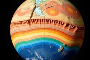
Earth Structure: The Main Units
- Earth's compositional layers include the crust, mantle, and core.
- Earth's rheological (physical) layers are the lithosphere, asthenosphere, and mesosphere.
- Plate tectonics explains the function of Earth's uppermost layer.
- The crust is a product of mantle melting with higher magnesium/iron ratio and less silicon/aluminum than mantle rocks.
- Lithosphere is rigid over geologic time scales while asthenosphere deforms in a ductile manner.
- Oceanic and continental are the two types of lithosphere which make up tectonic plates that move relative to each other
- The lithosphere and asthenosphere form the upper mantle.
- Extending from the 660 boundary to the outer core, the mesosphere corresponds to the lower mantle.
Asthenosphere Phase Changes
- At 410 km depth: Mg, Fe, Si, and O are primarily within olivine and pyroxene.
- Below 410 km depth, olivine becomes unstable and is replaced by higher density polymorph—spinel.
- The material below 410 km has a similar overall composition, but the minerals have a more compact structure.
- At 660 km depth: Spinel gives way to Mg-perovskite and Mg-wustite.
- Mg-perovskite is the most abundant solid on Earth, and it appears stable through much of the mantle.
Earthquake Distribution and Belts
- Earthquakes are organized along distinct belts.
- The circum-Pacific seismic belt (ring of fire) is the world's greatest earthquake belt located along the rim of the Pacific Ocean.
- The second most important seismic belt, the Alpide belt, spans from Sumatra through the Himalayas and the Mediterranean, and out into the Atlantic.
- A third prominent belt is the mid-Atlantic belt, that is splitting Africa apart.
- Most of the world's volcanic activity is concentrated along earthquake belts.
- Seismic belts divide the earth's surface into plates
Key Elements of Plate Tectonics
- Pangea is the super continent formed by plate tectonics
- The process is attributed to Alfrado Wegener
- Seven major lithospheric plates include the North American, South American, Pacific, African, Eurasian, Australian-Indian, and Antarctic plates.
- New plate material is generated at mid-ocean ridges through seafloor spreading (divergent plates), forming igneous rocks from magma.
- The oceanic lithosphere that is formed becomes part of a rigid plate.
- To maintain a constant Earth surface area, seafloor spreading must be balanced by plate consumption elsewhere.
- Plate motion is accommodated along plate boundaries, which are vanishing, and are measured.
Divergent Boundaries
- Plates move apart, magma rises and cools to form lithosphere.
- Divergent boundaries are typically expressed as mid-oceanic ridges, also called accreting or constructive.
- At divergent boundaries, new plate material derived from the mantle is added to the lithosphere, new oceanic crust is formed at the crest of an oceanic ridge.
- Two or more plates pull apart and molten material rises through a rift zone, with the newest magma at the rift, newer crust travels equally from the center, and oceanic crust records reversed and normal polarity.
- Seafloor spreading leads to new crest formation, the seafloor grows older with distance from the rift zone, cools, becomes denser, and is buried under sediments
Continental Rifting
- Continental rifting occurs when tensional forces acting on the lithosphere thin it, promoting upwelling in the mantle, potentially leading to the formation of a long, narrow sea.
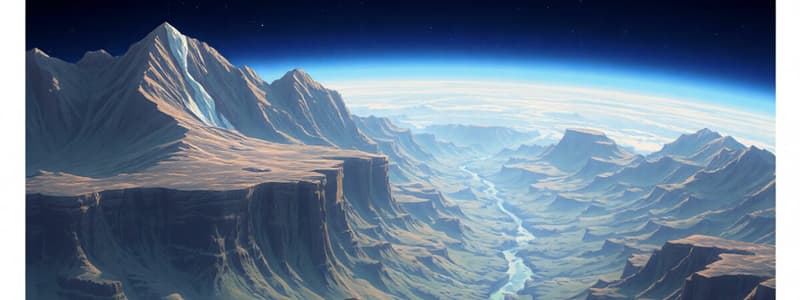
Convergent Boundaries
- Plates move toward each other, forming mountain belts and volcanoes.
- Oceanic plates may sink into the mantle along a subduction zone, typically marked by a deep ocean trench.
- Subduction zones and areas of intense volcanic and earthquake activity make up destructive boundaries, as plates move toward one another
- Oceanic plates move toward each other with the denser plate undergoing subduction.
- The plate that is subducted takes water with it which is the origin of the volcano formation since liquidus rock melts easier
- Continental collisions occur when lithosphere caps overlap
- The downgoing plate in a convergent boundary often penetrates the mantle to about 700 km.
Transform Boundaries
- Plates slide past one another, creating fault zones and earthquakes that mark the boundary like the San Andreas Fault in California.
- Transform Boundaries Create big earthquakes because friction is the source of the energy released
- They are also called conservative boundaries.
Relative Velocity
- Plate motion can be described using relative velocities
- Relative velocities are used to describe how fast and in what direction plates are moving in relation to each other near plate boundaries
- The barbed line is the symbol for a subduction zone with plates moving relative to each other.
- The barbs are on the side of the overriding plate, pointing away from the subducting or down-doing plate.
- The single line is the symbol for a transform (conservative) boundary
- All lines are subject to magnitude and the velocity of plate motion
Plate Tectonics on a Sphere: Rotation Axes and Poles
- Plate movement on Earth's surface can be described by viewing the surface of the planet as a sphere
- Euler's fixed-point theorem states every displacement from one position to another on the surface of the earth can be regarded as a rotation about a suitably chosen axis that passes through the center of the earth.
- The axis of rotation is chosen appropriately to pass through the center of the earth and reference displacement
- Poles of rotation/Euler's poles mark where the axis of rotation cuts through Earth's surface.
- Poles of rotation are mathematical points whose positions describe all point's direction of motion along a plate boundary.
- The sign convention is that a clockwise rotation is positive from the Earth's center while anticlockwise is positive from outside Earth, with one pole positive and the other negative.
- The maximum relative velocity for the same place
- Angular velocity and relative motion have been related
- Rotation vectors describe the present-day motion of plates on Earth's surface
Determining Rotation Poles and Vectors
- Present-day instantaneous poles of rotation and relative angular velocities between pairs of plates can be found by:
- The strike of active transform faults.
- Changes in spreading rate along a constructive boundary.
- Data analysis from an earthquake.
- Surveys of displacement across cross land plate boundaries using satellites.
Surveys of Displacements
- Surveys of displacement can be used where plate boundaries cross land to determine the local relative motions
- Displacement surveys measure rates of change through space and time
- Stream channels, roads, field boundaries and buildings may be displaced (for example).
- Satellites make it possible to accurately measure instantaneous plate motions:
- Satellite laser-ranging system (SLR) determines differences in distance between two Earth sites over time.
- Very-long-baseline interferometry (VLBI) is dependent on the sources known and baseline location
- VLBI uses quasars as signal sources and terrestrial radio telescopes are recievers.
- GPS (Global Positioning System) navigation is a global network of signal receivers
Satellite Laser-Ranging System (SLR)
- Measurement of distance (=range) between a ground station and a satellite = Satellite Laser Ranging (SLR)
- Ground station transmits a very short laser pulse from telescope to a satellite
- The laser pulse is retro-reflected by corner cube reflectors on the satellite back to the ground telescope
- Very precise clock at the ground station measures round trip time and measures Time measurement accuracy < 50 picoseconds, or < 1
- Three stations, one satellite position satellites if station is known
- Three satellites, one station positions station if satellite's orbit is known
Plate Boundaries: Changes Over Time
- Plates and plate boundaries do not stay the same for all time.
- Formation/destruction of plates are obvious causes for changing plate boundaries/motions.
- A plate may be lost down a subduction zone.
- Two continental plates may coalesce into one with resultant mountain building
- The shape of the boundary will directly effect the boundaries orientation and velocity
- If pole position changes, relative motions change.
- A drastic change in pole position (90°) would completely alter the status quo.
Triple Junctions
- Multiple plate boundaries and triple junctions exist on Earth. Triple junctions are points at which three plates meet.
- Stable triple junctions maintain relative plate motion and boundary azimuth.
- Unstable junctions exist temporarily before evolving
- 4+ plates at one point = always unstable so the system becomes two or more triple junctions instead.
- A ridge is written as R, a transform fault as F and a subduction zone (or trench) as T.
- Thus, a ridge-ridge-ridge junction is RRR, a fault-fault-ridge junction is FFR, and so on.
- Sixteen possible types of triple junction.
- One of these sixteen triple junctions is always stable (the RRR junction) if oblique spreading is not allowed.
- Two are always unstable (the FFF and FFR junctions).
Examples of Triple Junctions in Nature
- Azores: EUR, NOAM, and AFR
- Afar Region: African Rift Valley
- Riveras Triple Junctions: Where the North-American Plate meets the Cocos Plate and the Pacific Plate
Absolute Plate Motions
- There is no fixed point on the Earth's surface and plate motions are always related.
- Absolute plate motions describe the motion of plates relative to an imaginary fixed point.
- Hypothesizing that the Earth's mantle moves much more slowly than the plates describes absolute motions
- Absolute motions are calculated from the traces of oceanic island chains or continental volcanism by assuming the plate passed over a fixed heat source with respect to the mantle
- Processes that assume these traits include hotspot references, the measurement of 'hotspot tracks', the measurement of the rates of oceanic and continental plate transition
Studying That Suits You
Use AI to generate personalized quizzes and flashcards to suit your learning preferences.