Podcast
Questions and Answers
How does the biogeochemical cycle directly involve the atmosphere?
How does the biogeochemical cycle directly involve the atmosphere?
- Through the movement of tectonic plates influencing gas release
- By transferring chemical elements between the atmosphere, lithosphere, hydrosphere, and biosphere (correct)
- Through the hydrologic cycle, which evaporates water into the atmosphere
- Via the rock cycle, which releases gases during volcanic activity
Which factor primarily determines the classification of a natural event as a disaster?
Which factor primarily determines the classification of a natural event as a disaster?
- The duration of the event
- The geographical size of the area affected
- The total monetary value of property damage
- Whether international assistance is requested along with meeting criteria such as a certain number of people killed or affected, or a state of emergency declaration (correct)
Why is understanding Earth's tectonic cycle important for modern civilization?
Why is understanding Earth's tectonic cycle important for modern civilization?
- It helps predict changes in climate patterns
- It explains the formation of different rock types
- It is directly linked to the distribution of water resources
- It involves the creation, movement, and destruction of tectonic plates, influencing the distribution of rock and mineral resources and contributing to hazards (correct)
What is the primary distinction between the 'focus' and the 'epicenter' of an earthquake?
What is the primary distinction between the 'focus' and the 'epicenter' of an earthquake?
How does vegetation influence the stability of slopes in the context of landslides?
How does vegetation influence the stability of slopes in the context of landslides?
Which factor is LEAST likely to contribute to the increased vulnerability of an area to landslides?
Which factor is LEAST likely to contribute to the increased vulnerability of an area to landslides?
How do volcanic eruptions primarily affect climate and global temperatures?
How do volcanic eruptions primarily affect climate and global temperatures?
What is the primary goal of the 'Earthquake Hazard Reduction Program'?
What is the primary goal of the 'Earthquake Hazard Reduction Program'?
Why do many people continue to live near volcanoes despite the known risks?
Why do many people continue to live near volcanoes despite the known risks?
How does the Geohazard Mapping and Assessment Program contribute to disaster risk reduction?
How does the Geohazard Mapping and Assessment Program contribute to disaster risk reduction?
What is the key difference between a tropical cyclone and an extratropical cyclone?
What is the key difference between a tropical cyclone and an extratropical cyclone?
What is the primary requirement for a tropical disturbance to be classified as a hurricane or typhoon?
What is the primary requirement for a tropical disturbance to be classified as a hurricane or typhoon?
Which factor most significantly influences the rate and extent of river flooding?
Which factor most significantly influences the rate and extent of river flooding?
How does 'channelization' contribute to flood management?
How does 'channelization' contribute to flood management?
What is the primary cause of saltwater intrusion in coastal aquifers?
What is the primary cause of saltwater intrusion in coastal aquifers?
Flashcards
Natural Hazard
Natural Hazard
A natural process or event that can threaten human life and property.
Disaster
Disaster
A hazardous event with significant impact, exceeding defined criteria such as fatalities, injuries, or declared emergency.
Catastrophe
Catastrophe
A massive disaster requiring substantial monetary expenditure and a long recovery period.
Geologic Cycle
Geologic Cycle
Signup and view all the flashcards
Tectonic Cycle
Tectonic Cycle
Signup and view all the flashcards
Rock Cycle
Rock Cycle
Signup and view all the flashcards
Hydrologic Cycle
Hydrologic Cycle
Signup and view all the flashcards
Biogeochemical Cycle
Biogeochemical Cycle
Signup and view all the flashcards
Geologic Hazard
Geologic Hazard
Signup and view all the flashcards
Earthquake
Earthquake
Signup and view all the flashcards
Epicenter
Epicenter
Signup and view all the flashcards
Focus (Hypocenter)
Focus (Hypocenter)
Signup and view all the flashcards
Earthquake Intensity
Earthquake Intensity
Signup and view all the flashcards
Earthquake Magnitude
Earthquake Magnitude
Signup and view all the flashcards
Landslide
Landslide
Signup and view all the flashcards
Study Notes
- Natural hazard is a natural process and event that threatens human life and property
- Geologic, hydrometeorological, and coastal hazards can be categorized as natural hazards
- Disaster is a hazardous event over a limited time in a defined area
- Criteria for a natural disaster include 10+ people killed, 100+ people affected, state of emergency declaration, or international assistance request
- Catastrophe refers to a massive disaster requiring significant money and a long recovery time
Important Concepts
- Geologic cycle describes the complex interactions between tectonic, rock, hydrologic, and biogeochemical cycles
- Tectonic cycle involves the creation, movement, and destruction of tectonic plates
- It is responsible for the production and distribution of rock and mineral resources and hazards like volcanoes and earthquakes
- Rocks cycle is the largest geologic sub-cycle, and is linked to others
- It depicts the changing transition through geologic times of igneous, sedimentary, and metamorphic rocks
- Hydrologic cycle is the movement of water from oceans to the atmosphere and back
- Biogeochemical cycle involves the transfer or cycling of chemical elements through the atmosphere, lithosphere, hydrosphere, and biosphere
- Carbon is exhaled by animals as CO2, enters the atmosphere, and is taken up by plants
Geologic Hazards
- A geological hazard is a natural geologic event endangering human lives and threatening property
- Earthquakes, landslides, and volcanic eruptions are geologic hazards
Earthquakes
- Around one million earthquakes are felt each year, but few are noticed or major
- An earthquake occurs as the Earth's surface trembles when energy is released from strain in rock layers
- Earthquakes can be associated with volcanic eruptions or plate tectonics
Basic Earthquake Features
- Epicenter is the place on the Earth's surface above where the ruptured rocks broke up to produce an earthquake
- Focus is the point of initial breaking or rupturing within the Earth
- Hypocenter is directly below the focus
Earthquake Measurement
- Earthquakes are measured and compared by intensity, magnitude, and moment magnitude
- Intensity describes the effects of ground motion on people and structures
- Magnitude measures the amount of energy released
- Moment magnitude indicates the earthquake size based on the area that ruptured along a fault plane, movement slippage, and rock rigidity near the quake's focus
- Moment magnitude is used by most news reporters
- Ritcher Scale was developed by seismologist Charles Ritcher, used by some news reporters still
Effects/Linkages of Earthquakes
- Shaking and ground rupture are immediate effects of a catastrophic earthquake involving ground shaking with surface rupture and displacement
- Liquefaction during earthquakes causes intense shaking that can turn near-surface water-saturated sand from solid to liquid
- Regional changes in land elevation includes vertical deformation like uplift and subsidence, causing damage in coastal areas and along streams, and changing groundwater table
Landslides
- Landslides are natural hazards closely linked to earthquakes because they are one of the most common triggers, particularly in hilly or mountainous areas
- Earthquake-triggered landslides can be destructive and cause great loss of life
- Fires can start as shaking ground and surface displacements break electrical power and natural gas lines.
- Fires after earthquakes are more dangerous because broken firefighting equipment, blocked streets, and broken water mains
- Disease can be a hazard as earthquakes cause loss of sanitation/housing, contaminated water supplies, disruption of public health services, and disturb the natural environment
Landslides Defined
- A landslide is downslope movement of rock, debris, earth, or soil
- A slope is a slant or incline on a land surface
- Landslide forces rely on earth material, topography/slope angle, climate, vegetation, water and time
Factors of Landslides
- Earth material relates to mineral composition, cementation, and weaknesses like layering in sedimentary/metamorphic rock or geographic fault lines
- Topography and slope angle refers to the height of a hill or mountain above land, with steeper slopes increasing the driving force
- Climate involves weather over years/decades, influencing timing/amount of water that erodes a slope and affects vegetation
- Vegetation cushions the impact of falling rain to prevent erosion, but also adds weight
- Water in slopes leads to saturated soil slips/debris flows, deep infiltration over months/years, and water erosion, all decreasing stability
- Time causes weathering of rocks, reducing their strength through water contact
Man-Made Landslide Factors
- Intense deforestation, soil erosion, construction in prone areas, roads/communication lines in mountains, weak foundations, buried pipelines, and a lack of understanding landslide hazards are man-made factors of vulnerability
Landslide Effects/Linkages
- Landslides can cause people/property to get hit or buried in falling debris
- Homes, roads, and utilities on hills can be damaged
- Flooding can occur upstream as landslides block rivers, spreading disease from disturbed fungal spores
- Landslides are caused by earthquakes, volcanoes, storms, and fires
- Landslides may be responsible for flooding if they form an earthen dam across a river or cause tsunamis/flooding when water is displaced
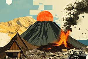
Volcanic Eruptions
- Volcanic eruptions are dramatic and violent agents of change
- They are significant geologic hazards due to widespread and long-lasting effects
- Volcanic activity is related to plate tectonics, with most volcanoes near plate boundaries
- This activity rises from spreading and sinking lithospheric plates that interact with earth materials, producing magma
Volcanic Terminology
- Magma is molten rock under the Earth's crust
- Lava is molten rock erupted by a volcano
- Vent is the opening of a volcano where lava and volcanic material extrude
The Ring of Fire
- The Ring of Fire is an area in the Pacific Ocean basin with a high number of earthquakes and volcanic eruptions
- It is a 40,000 km horseshoe shape associated with oceanic trenches, volcanic arcs, belts, and plate movements
Volcano Classification
- Active volcanoes are currently erupting or showing unrest
- Dormant volcanoes are not active but could become active again
- Extinct volcanoes are considered unlikely to erupt again
Eruptions
- An eruption occurs when magma, gases, or steam break through vents in the Earth's surface
- Mild eruptions discharge steam/gases or expel lava quietly
- Strong eruptions involve violent explosions that send clouds of gas-laden debris into the atmosphere or sideways from a collapsed volcano portion
Earthquake Mitigation
- Earthquake hazard reduction programs may come from government officials or the National Disaster Risk Reduction Management Council
- The goals are to understand earthquake source, determine earthquake essentials, predict earthquake effects, apply research, strategically locate critical facilities, and use structural protection/education
- These programs also aim to increase insurance/relief measures and prepare people
Earthquake Preparations
- Before: Home safety checks can increase survivability, including chimney/foundation checks and securing large objects like water heaters
- During: Teach "drop, cover, and hold on" which means to drop to the ground, take cover under sturdy furniture, and hold on until shaking stops
- After: Take deep breaths, look around, leave building carefully, avoid moving during shaking, turn off gas lines, and move to an open area/away from fallen power lines/trees
Landslide Mitigation
- Identify areas likely to experience landslides
- Educate and warn people of impending landslides
- Design slopes/engineering structures for prevention
- Control landslides after they've started
- Avoid development on sites where landslides are occurring or likely to occur
- Evacuate and relocate people when necessary
Volcanic Eruption Mitigation
- Forecasting is done by the Philippine Institute of Volcanology and Seismology
- Education and Evacuation provides information on how people perceive a volcanic hazard
- People live near volcanoes for various reasons, including being born there, fertile land, optimism, or economic limitations
Geohazard Mapping/Assessment
- Geohazard Mapping and Assessment Program of the Department of Environment and Natural Resources (DENR), implemented by Mines and Geosciences Bureau (MGB)
- Aims to identify geologic hazard-susceptible areas and lessen the impact
- It has determined landslide and flood prone areas
- The developed map is accessible on the Mines and Geosciences Bureau's website
Definition of Hydrometeorological Hazards
- Hydrometeorological hazard is an atmospheric, hydrological, or oceanographic process that endangers human lives and threatens property
- Cyclones, monsoons, flooding, and tornadoes are hydrometeorological hazards
Cyclones Defined
- Cyclones are coined from the Greek word meaning "coil of snake"
- An area or center of low atmospheric pressure with rotating winds
- Tropical cyclones form over warm tropical/subtropical ocean water between 5° and 20° latitude
- Extratropical cyclones develop over land/water in temperate regions between 30° and 70° latitude
- Cyclone intensity is indicated by wind speeds and lowest atmospheric pressure
Cyclone Terminology
- Hurricanes are strong tropical cyclones in the Atlantic and Pacific Oceans, named after a Caribbean word for the god of winds/destruction
- Typhoons are strong tropical cyclones in the Pacific Ocean west of the International Dateline, named after a Chinese word for "scary wind"
- A tropical cyclone is a large thunderstorm complex rotating around an area of low pressure over warm tropical/subtropical water
- Low-intensity cyclones are tropical depressions/storms
- High-intensity cyclones are hurricanes/typhoons
Requirements to be Hurricane/Typhoon
- To be classified as a hurricane/typhoon, a tropical cyclone must have sustained winds of at least 119 km/hr
- Hurricanes/typhoons need tremendous heat to develop and only form where the sea surface temp is at least 26°C
Stages of Hurricanes/Typhoons
- Tropical Disturbance: A large area of unsettled weather, generally 200-600 km diameter, with a mass of thunderstorms that persists for over 24 hrs, may lead to tropical depression
- Tropical Depression: Tropical disturbance becomes a tropical depression as winds increase and spiral, forming a low pressure center
- Tropical Storm: Depression becomes a tropical storm, winds reaching more than 63km/hr and the storm is given a name, and Hurricane/Typhoon forms if conditions worsen
Features of a Hurricane/Typhoon
- Rainbands are clouds that spiral around the hurricane/typhoon
- Eyewall is the innermost band of clouds with the most intense winds
Effects of Cyclones
- Effects of cyclones include flooding, thunderstorms, tornadoes, storm surge, heavy rains, and high winds
Monsoons Defined
- A monsoon is climate marked by seasonal shifts in prevailing winds between winter and summer, found in tropical Asia, Australia, Africa, and the Indian Ocean
- Monsoon rainfall is important to agriculture for over half the world's population
- Research is being conducted to increase understanding of monsoon predictability, maximizing its benefits, and reducing extreme event impacts
Types of Monsoon Winds
- Northeast Monsoon occurs from November to February, causing cold temperatures and rain over the eastern coast of the Philippines
- Southwest Monsoon occurs from July to September, responsible for rainfall during the wet season
- Trade winds generally come from the east and are prevalent when NE monsoons are weak
Flooding
- Flooding is a natural process of a river's overbank flow
- River flooding is related to the amount/distribution of precipitation in the drainage basin, rate of soaking into the earth, and how quickly surface runoff reaches the river
Terms Related to Flooding
- River refers to a natural stream of water that flows in a channel with defined banks
- Stream refers to any body of water that flows in a channel
- Drainage basin refers to the region drained by a single stream or river
- Runoff is water from rain/snow flowing over the ground into streams
Types of Floods
- Flash floods result from intense rainfall over a small area in a short duration
- Downstream floods cover a wide area and are usually produced by storms of long duration that saturate the soil and produce increased runoff
Effects of Flooding
- Primary effects are injury, loss of life, and damage to farms, homes, railroads, bridges, roads, and communication systems caused by swift currents, debris, and sediment
- Secondary effects result from the disruption and malfunction of services, causing short term pollution of rivers, hunger, disease, and displacement
Tornadoes
- Tornadoes are small-diameter column of violently rotating air developed within a convective cloud and in contact with the ground
- These atmospheric vortices generate the strongest winds with measured extreme events above 500 km/hr
- Tornadoes are a result of instability within air masses and wind systems
- Wind speeds and destructiveness are measured through the Enhanced Fujita Scale of tornado intensity
- Waterspouts are tornadoes that form overwater
Mitigation/Adaptation for Hydrometeorological Hazards
- Accurately forecast storms, issue advisories, adhere to building codes, have organized evacuation procedures, hazard preparedness, education, and insurance programs are all strategies to employ
Flood Response
- The Geohazard Mapping and Assessment Program informs discussion on landslides, mitigation, and adaptation
- Construction of physical barriers such as concrete flood walls can occur
- Channelization is defined as straightening, deepening, widening, clearing, and lining existing streams
- Relocating people from floodplains/flood prone areas, education, and preparing for a flood are all examples of responses
Flood Preparation
- Check with your local flood control agency to see if your property is at risk from flooding
- Make up a flood kit, including a flashlight, blankets, raingear, battery powered radio, first-aid kit, rubber gloves, and key to personal documents.
- Talk about possible flooding with your family and housemates, considering writing a flood plan, and store notes to your flood kit
Flood Response Actions
- Be prepared to evacuate, observe water levels, and stay tuned to a radio and television news and weather reports
- Move people, pets, and valuables upstairs or to a higher ground
- Do as much as possible in daylight
- Keep warm and dry
Coastal Processes
- Coastal landforms are created by a wide variety of coastal processes with two major processes: erosion and accretion
- Erosion is the group of processes where debris or rock material is loosened and dissolved by destructive waves, causes property damage, and requires adjustments
- Accretion refers to the gradual increase in the area of land as a result of sedimentation
Coastal Hazards
- Waves are generated by offshore winds, sometimes thousands of kilometers from where the waves reach the shoreline
- Rogue waves are gigantic and extremely dangerous waves, larger than similar waves in the sets around them
- Rogue waves can strike the shore and somewhere in the open ocean and may reach 100 ft
Sea Level Change
- Sea level change results from a number of processes, some operate locally and others affect regional or world wide ocean effects
- Eustatic sea level, also know as global sea level, is controlled by processes that affect the overall volume of water in the ocean and the shape of the ocean basins
- Relative sea level is the position of the sea at the shore influenced by the movement of the land and the movement of the water
Storm Surge
- Storm surge is the local rise of sea level resulting from water pushed toward the shore by winds swirling around a storm
- The causes are stress exerted by wind on the water surface and low atmospheric pressure in the storm that pulls the sea surface
- A storm surge is a continual increase in sea level as a storm approaches landfall
Saltwater Intrusion
- Saltwater intrusion is the induced flow of saltwater into freshwater aquifers caused by groundwater over-pumping
Saltwater Intrusion Terms
- Groundwater is the water beneath the surface of the ground, consisting largely of surface water that has seeped down
- Aquifer is any geological formation containing or conducting ground water, especially one that supplies the water for wells, springs, etc
Saltwater Impacts
- Saltwater intrusion happens when groundwater levels in aquifers are depleted faster than they can recharge
- The encroaching seawater will encounter an area known as the zone of dispersion, where the freshwater and saltwater mix, contaminating freshwater supplies
- The limited potable drinking water supply in areas affected by saltwater intrusion and water with salinity detrimental to growing agriculture are effects of saltwater intrusion
Coastal Hazard Mitigation/Adaptation
- Evacuation plans and shelters where policy makers have understanding of storm surges and adequate willingness to anticipate future storm surges needed
- Relocating people from coastal erosion and storm surge prone areas can occur through initiatives by government or residents
- Education could include distribution of pamphlets and videos, workshops/trainings, and internet information
- Prevention and control of saltwater intrusion by reducing pumping or using time-share pumping from wells, relocating wells, or redesigning the well field
Studying That Suits You
Use AI to generate personalized quizzes and flashcards to suit your learning preferences.