Podcast
Questions and Answers
According to Section 25 of the MRTP Act, within what timeframe must the Existing Land Use (ELU) Map be prepared from the date of declaration of intention?
According to Section 25 of the MRTP Act, within what timeframe must the Existing Land Use (ELU) Map be prepared from the date of declaration of intention?
- 3 months
- 6 months (correct)
- 12 months
- 18 months
What is the maximum permissible extension period for the preparation of the Existing Land Use (ELU) Map, as outlined in Section 25 of the MRTP Act?
What is the maximum permissible extension period for the preparation of the Existing Land Use (ELU) Map, as outlined in Section 25 of the MRTP Act?
- 3 months
- 6 months
- 9 months
- 12 months (correct)
Considering both the initial period and the maximum extension, what is the total maximum time allowed for the preparation of the Existing Land Use (ELU) Map?
Considering both the initial period and the maximum extension, what is the total maximum time allowed for the preparation of the Existing Land Use (ELU) Map?
- 18 months (correct)
- 1 year
- 6 months
- 9 months
Under Section 25 of the MRTP Act, which official is primarily responsible for preparing the Existing Land Use Map and submitting it the Planning Authority?
Under Section 25 of the MRTP Act, which official is primarily responsible for preparing the Existing Land Use Map and submitting it the Planning Authority?
Which of the following elements are required to be included in the Existing Land Use (ELU) Map, as per the MRTP Act?
Which of the following elements are required to be included in the Existing Land Use (ELU) Map, as per the MRTP Act?
Which of the following is NOT a primary purpose of preparing the Existing Land Use (ELU) Map according to Section 25 of the MRTP Act?
Which of the following is NOT a primary purpose of preparing the Existing Land Use (ELU) Map according to Section 25 of the MRTP Act?
According to Section 25, which of the following features would be explicitly represented within an Existing Land Use (ELU) Map?
According to Section 25, which of the following features would be explicitly represented within an Existing Land Use (ELU) Map?
The Existing Land Use (ELU) Map primarily aids in the understanding of which aspect of an area's development?
The Existing Land Use (ELU) Map primarily aids in the understanding of which aspect of an area's development?
To which official body or authority is the completed Existing Land Use (ELU) Map submitted after its preparation?
To which official body or authority is the completed Existing Land Use (ELU) Map submitted after its preparation?
When collecting data for the Existing Land Use map, what type of infrastructure is primarily focused on for inclusion?
When collecting data for the Existing Land Use map, what type of infrastructure is primarily focused on for inclusion?
Flashcards
ELU Map Time Limit
ELU Map Time Limit
Must be prepared within 6 months from the date of declaration of intention.
Contents of ELU Map
Contents of ELU Map
Residential, industrial, agricultural, public areas, water & electric facilities, roads and transport.
Purpose of ELU Map
Purpose of ELU Map
Identify infrastructure shortfalls, development trends, town character, and basis for future planning.
Who Prepares ELU?
Who Prepares ELU?
Signup and view all the flashcards
Existing Land Use (ELU) Map
Existing Land Use (ELU) Map
Signup and view all the flashcards
Extension Period for ELU Map
Extension Period for ELU Map
Signup and view all the flashcards
Infrastructure in ELU
Infrastructure in ELU
Signup and view all the flashcards
Social Infrastructure Data in ELU
Social Infrastructure Data in ELU
Signup and view all the flashcards
Study Notes
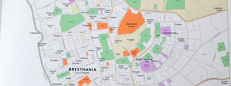
Section 25 of the MRTP Act, 1966: Existing Land Use (ELU) Map
- The Existing Land Use Map (ELU) preparation is detailed in Section 25 of the MRTP Act, 1966.
Time Limit for ELU Map Preparation
- The ELU Map must be prepared within 6 months from the date of declaration of intention as per Section 23.
- An extension of up to 1 year can be granted, making the maximum time allowed 1.5 years.
Contents of ELU Map
- The ELU Map shows existing land uses, including residential, industrial, and agricultural areas, along with public and semi-public spaces.
- Public installations and services are included, such as water supply, electric substations, sewerage, and fire stations.
- Utilities and infrastructure like roads, transport hubs, bus depots, and landmarks are shown on the ELU Map.
Purpose and Importance of ELU Map
- The ELU helps identify infrastructure and service shortfalls.
- It reveals the development trend and growth pattern of the city.
- The map helps in understanding the character of the town, whether it is residential, industrial, or mixed-use.
- The ELU provides a basis for planning future land use (PLU), road networks, and infrastructure improvements.
- Social infrastructure data, including schools, hospitals, community centers, police stations, and fire services, are captured.
Responsibility for ELU Map Preparation
- The Town Planning Officer (TPO) prepares the ELU map.
- The TPO then submits the map to the Planning Authority.
Studying That Suits You
Use AI to generate personalized quizzes and flashcards to suit your learning preferences.


