Podcast
Questions and Answers
In which mountain range is Mount Everest located?
In which mountain range is Mount Everest located?
- The Rocky Mountains
- The Himalayas (correct)
- The Andes
- The Karakoram
What is the height of Mount Everest?
What is the height of Mount Everest?
- 8000m
- 8850m (correct)
- 9000m
- 8500m
Who led the 1953 expedition to climb Mount Everest?
Who led the 1953 expedition to climb Mount Everest?
- Edmund Hillary
- Colonel John Hunt (correct)
- Tenzing
- Hilary
What is the name of the steep and difficult wall of ice on the route to Mount Everest?
What is the name of the steep and difficult wall of ice on the route to Mount Everest?
What is one of the main physical hazards for climbers on Mount Everest?
What is one of the main physical hazards for climbers on Mount Everest?
Why is 8000 meters in altitude significant for climbers?
Why is 8000 meters in altitude significant for climbers?
What is the name of the process that formed the Himalayas, including Mount Everest?
What is the name of the process that formed the Himalayas, including Mount Everest?
What type of rock is found at the base of Mount Everest?
What type of rock is found at the base of Mount Everest?
In which sub-range of the Himalayan mountain range is Mount Everest located?
In which sub-range of the Himalayan mountain range is Mount Everest located?
What is the most popular route to climb Mount Everest?
What is the most popular route to climb Mount Everest?
What type of vegetation is commonly found in the high-altitude environment of Mount Everest?
What type of vegetation is commonly found in the high-altitude environment of Mount Everest?
Who made the first successful ascent of Mount Everest?
Who made the first successful ascent of Mount Everest?
What is the typical temperature range at the summit of Mount Everest?
What is the typical temperature range at the summit of Mount Everest?
What is the primary occupation of the Sherpa people in the lower Himalayan regions?
What is the primary occupation of the Sherpa people in the lower Himalayan regions?
What is the purpose of the series of camps established on Mount Everest?
What is the purpose of the series of camps established on Mount Everest?
Which of the following climbing seasons is the most popular and relatively stable?
Which of the following climbing seasons is the most popular and relatively stable?
What is the altitude of Camp I on Mount Everest?
What is the altitude of Camp I on Mount Everest?
What is the primary cause of Acute Mountain Sickness (AMS)?
What is the primary cause of Acute Mountain Sickness (AMS)?
What is a unique adaptation of the Sherpa people to high altitude?
What is a unique adaptation of the Sherpa people to high altitude?
What is the process by which the Indian plate is being pushed beneath the Eurasian plate?
What is the process by which the Indian plate is being pushed beneath the Eurasian plate?
What is the primary symptom of altitude sickness?
What is the primary symptom of altitude sickness?
What is the typical rate of elevation gain of the Himalayas?
What is the typical rate of elevation gain of the Himalayas?
What is the name of the process by which the body adapts to decreasing oxygen levels at high altitude?
What is the name of the process by which the body adapts to decreasing oxygen levels at high altitude?
What is the elevation of Base Camp on Mount Everest?
What is the elevation of Base Camp on Mount Everest?
Why do climbers typically spend several nights at each camp on Mount Everest?
Why do climbers typically spend several nights at each camp on Mount Everest?
What is the result of the collision between the Indian and Eurasian tectonic plates?
What is the result of the collision between the Indian and Eurasian tectonic plates?
Flashcards are hidden until you start studying
Study Notes
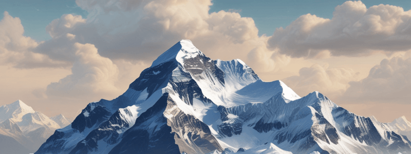
Location and Features of Mount Everest
- Mount Everest is located in Nepal, part of the Himalayas, and stands at 8850m high.
- It is a dream destination for mountain climbers.
The First Ascent of Mount Everest
- The first successful ascent of Mount Everest was led by Colonel John Hunt on May 28, 1953.
- The two explorers, Hilary and Tenzing, reached the summit on this expedition.
Route to the Summit of Mount Everest
- The main route to the summit passes through:
- Base Camp
- Khumbu Icefall
- Camp 1
- Camp 2
- Camp 3
- Lhotse Face
- South Col
- South Summit
- Mount Everest
Dangers of Climbing Mount Everest
- Physical hazards:
- Steep terrain
- Risk of avalanche and crevasse
- Health issues:
- Altitude sickness
- Very low temperatures
Significance of 8000 Metres Altitude
- At 8000m, climbers face:
- Lack of oxygen
- Weakened physical state
- Increased stress leading to poor decisions
Geology of the Himalayas and Mount Everest
- The Himalayas formed due to continental drift, crashing, and folding of the Indian tectonic plate.
- The different layers of rock on Mount Everest include:
- Schists (metamorphic) at the base
- Granite further up
- Shale, sandstone, and limestone towards the top
The Sherpa People
- The Sherpa people are from the Everest region (Solu-Khumbu District) and originated from Eastern Tibet.
- They were skilled in carrying goods at high altitude and became porters for better pay.
The Issue of Dead Climbers on the Mountain
- Bodies do not decay in the ice, serving as a reminder to climbers of the dangers of Mount Everest.
- However, the presence of dead bodies can be disturbing to climbers.
Geography of Mount Everest
- Located in the Himalayas on the Nepal/China border at 27° 59' N latitude and 86° 55' E longitude
- Stands at 8,848 meters (29,029 ft) above sea level, making it the highest mountain on Earth
- Formed by the collision of the Indian and Eurasian tectonic plates, creating a fold mountain
- Part of the Mahalangur Himal sub-range
Climbing Routes and Challenges
- Two main climbing routes: South Col (Nepal side) and North Col (Tibet side)
- South Col route is the most popular and relatively safest route
- North Col route is more challenging and exposed to harsh weather
- Climbing seasons: Spring (March to May) is the best time, with relatively stable weather, and Autumn (September to November) is the second-best time, with fewer crowds
- Climbing difficulties include high altitude, extreme weather conditions, steep rock and ice walls, and crevasses and avalanches
Ecosystem and Environment
- Mount Everest has an extreme environment with low oxygen levels, extreme temperatures, and high winds
- Limited biodiversity, with mosses, lichens, and grasses in lower altitudes, and no trees above 5,500 meters (18,000 ft)
- Endangered species include the snow leopard, Tibetan antelope, and Himalayan jumping spider
- Human impact on the ecosystem includes litter, pollution, and human waste
Expedition History and Notable Climbers
- First ascent by Tenzing Norgay and Sir Edmund Hillary in 1953
- Notable expeditions include the 1922 British expedition, which reached 8,000 meters (26,247 ft), and Reinhold Messner's solo ascent in 1980
- The 1996 disaster on the mountain resulted in multiple fatalities
- Over 4,000 people have successfully climbed Mount Everest
Weather Patterns and Conditions
- Temperatures range from -60°C to -10°C (-76°F to 14°F), with wind speeds reaching up to 100 km/h (62 mph)
- Heavy snowfall occurs, especially during the monsoon season (June to September)
- Climbing windows occur during brief periods of relatively stable weather, often during Spring and Autumn
- Winter season (December to February) brings extreme cold and low oxygen levels
Geography
- Located in the Himalayas on the border between Nepal and Tibet, China
- Highest peak above sea level: 8,848 meters (29,029 ft)
- Part of the Mahalangur Himal sub-range
- Formed from the collision of the Indian and Eurasian tectonic plates
Ecosystem
- Alpine zone: above 5,500 meters, characterized by limited vegetation and extreme temperatures
- Subalpine zone: 3,500-5,500 meters, features scrubby vegetation and harsh conditions
- Temperate zone: 2,500-3,500 meters, coniferous forests, and moderate climate
- Subtropical zone: below 2,500 meters, dense forests, and mild climate
- Home to endangered species, including the snow leopard and Himalayan jumping spider
Weather Conditions
- Temperatures range from -60°C to 25°C (-76°F to 77°F)
- Winds can reach up to 280 km/h (175 mph)
- Oxygen levels are only 33% of sea-level oxygen levels
- Weather patterns include monsoon season (June-September) and winter storms (December-February)
Expedition History
- First ascent achieved by Tenzing Norgay and Sir Edmund Hillary on May 29, 1953
- Notable expeditions include 1922: British expedition, 1933: British expedition, and 1996: IMAX expedition
- Over 300 reported deaths since 1953
Climbing Routes
- South Col route: most popular route, via Nepal
- North Col route: via Tibet
- West Ridge route: more challenging, via Nepal
- Other routes: East Face, West Face, and Northeast Ridge
Sherpa People
- Indigenous to the Himalayas
- Expert mountaineers and guides
- Tenzing Norgay: first Sherpa to climb Everest, 1953
- Lama Srb: first Sherpa to climb the Seven Summits
Himalayas Formation
- Continental collision: Indian plate collided with Eurasian plate, 50 million years ago
- Orogenesis: process of mountain building, resulting in the Himalayan mountain range
Altitude Sickness
- Acute Mountain Sickness (AMS): symptoms include headache, nausea, and fatigue
- High Altitude Pulmonary Edema (HAPE): fluid buildup in lungs, life-threatening
- High Altitude Cerebral Edema (HACE): fluid buildup in brain, life-threatening
- Prevention: gradual ascent, rest, hydration, and oxygen therapy
Everest Camps
- Base Camp: 5,364 meters (17,598 ft), starting point for climbs
- Camp I: 6,065 meters (19,900 ft)
- Camp II: 6,400 meters (20,997 ft)
- Camp III: 7,200 meters (23,622 ft)
- Camp IV: 7,906 meters (25,938 ft), final camp before the summit
Geography
- Located in the Mahalangur Himal sub-range of the Himalayan mountain range in Asia
- Situated on the border between Nepal and Tibet, China
- Highest peak above sea level, with an elevation of 8,848 meters (29,029 ft)
- Also known as Sagarmatha in Nepali and Chomolungma in Tibetan
Climbing Routes
- Most popular routes:
- South Col route (Nepal side) is the safest and most frequently used
- North Col route (Tibet side) is more challenging and exposed to harsh weather
- Other routes include:
- West Ridge route
- East Ridge route
- Southwest Face route
Ecosystem
- High-altitude environment with extreme temperatures and low oxygen levels
- Limited vegetation consists of:
- High-altitude grasses and shrubs
- Rare species of rhododendron and juniper
- Home to several endangered species, including:
- Snow leopard
- Himalayan jumping spider
- Impeyan pheasant
Expedition History
- First successful ascent by Tenzing Norgay and Sir Edmund Hillary in 1953
- Over 4,000 successful ascents to date
- Notable expeditions include:
- 1922: British Mount Everest Expedition led by George Mallory and Andrew Irvine
- 1963: First American ascent by Jim Whittaker
Weather Conditions
- Extreme weather conditions include:
- Temperatures ranging from -60°C to -10°C (-76°F to 14°F)
- Wind speeds up to 100 km/h (62 mph)
- Frequent and heavy snowfall
- Climbing seasons:
- Spring (March to May) is the most popular and relatively stable weather
- Autumn (September to November) is less crowded and more challenging weather
Sherpa People
- Indigenous people living in the Himalayas, primarily in Nepal
- Renowned for their mountaineering skills and high-altitude adaptations
- Traditional occupations:
- Porters and guides for mountaineering expeditions
- Farmers and traders in the lower Himalayan regions
Himalayas Formation
- Formed as a result of the Indian tectonic plate colliding with the Eurasian plate
- Ongoing process of orogenesis, resulting in the continued uplift of the Himalayas
- Estimated to have risen by 1 inch (2.5 cm) in the past 50 years
Altitude Sickness
- Acute Mountain Sickness (AMS) is a serious and potentially life-threatening condition
- Caused by the body's inability to adapt to high altitudes and low oxygen levels
- Symptoms include:
- Headaches
- Nausea and vomiting
- Fatigue and weakness
- Shortness of breath
Everest Camps
- Series of camps established at various altitudes to support climbers and expeditions
- Camps include:
- Base Camp (5,364 meters / 17,598 ft): main camp and starting point for climbs
- Camp I (6,065 meters / 19,900 ft): first camp on the mountain
- Camp II (6,400 meters / 20,997 ft): second camp, also known as Advanced Base Camp
- Camp III (7,200 meters / 23,622 ft): third camp, located on the West Ridge
- Camp IV (7,906 meters / 25,938 ft): final camp, also known as the South Col
Sherpa People
- Originate from the Himalayas
- Traditionally, farmers and traders, now guides and porters for mountaineers
- Physically adapted to high altitude with:
- Increased oxygen delivery to body tissues
- Efficient oxygen binding to hemoglobin
- High mitochondrial density in muscle cells
- Many have climbed Mount Everest multiple times, holding records for most ascents
Himalayas Formation
- Formed 50 million years ago through the collision of Indian and Eurasian tectonic plates
- Ongoing process, still rising by 1 inch (2.5 cm) every year
- Indian plate is being pushed beneath the Eurasian plate (continental subduction)
Altitude Sickness
- Also known as Acute Mountain Sickness (AMS)
- Caused by lower air pressure and oxygen levels at high altitudes
- Symptoms include:
- Headache
- Nausea and vomiting
- Fatigue and weakness
- Dizziness and lightheadedness
- Fatal if not recognized and treated promptly
- Acclimatization is key to prevent AMS
Everest Camps
- Series of camps established on the mountain to facilitate climbers' ascent
- Camps located at:
- Base Camp (5,364m/17,598ft)
- Camp I (6,065m/19,900ft)
- Camp II (6,400m/20,997ft)
- Camp III (7,200m/23,622ft)
- Camp IV (8,000m/26,247ft)
- Each camp provides temporary refuge, with tents, food, and medical supplies
- Climbers spend several nights at each camp to acclimate to increasing altitude
Studying That Suits You
Use AI to generate personalized quizzes and flashcards to suit your learning preferences.


