Podcast
Questions and Answers
Mid-latitude cyclones primarily form within which latitudes?
Mid-latitude cyclones primarily form within which latitudes?
- 30° to 60° north and south of the equator (correct)
- 0° to 15° north and south of the equator
- 60° to 90° north and south of the equator
- 0° to 30° north and south of the equator
What air masses are required for the conditions of Mid-latitude cyclone formation?
What air masses are required for the conditions of Mid-latitude cyclone formation?
- Cold air masses rising above warm air masses
- Cold, dry air masses colliding with other cold, dry air masses
- Warm air masses colliding with cold air masses (correct)
- Warm, dry air masses colliding with other warm, dry air masses
Which of the following is NOT a typical stage in the development of a mid-latitude cyclone?
Which of the following is NOT a typical stage in the development of a mid-latitude cyclone?
- Initial Stage: Interaction of warm and cold air masses
- Dissipation Stage: Cyclone weakens and loses its structure (correct)
- Mature Stage: Well-developed cold and warm sectors leading to weather changes
- Development Stage: Formation of distinct warm and cold fronts
Which type of front is associated with rapidly falling temperatures and thunderstorms?
Which type of front is associated with rapidly falling temperatures and thunderstorms?
How do mid-latitude cyclones influence the environment?
How do mid-latitude cyclones influence the environment?
Which of the following is a key management strategy to minimize the damage caused by mid-latitude cyclones?
Which of the following is a key management strategy to minimize the damage caused by mid-latitude cyclones?
What is the primary characteristic used to identify mid-latitude cyclones on synoptic weather maps?
What is the primary characteristic used to identify mid-latitude cyclones on synoptic weather maps?
In the context of weather analysis, what does 'Paper GIS Development' primarily involve?
In the context of weather analysis, what does 'Paper GIS Development' primarily involve?
Tropical cyclones typically form over ocean waters with temperatures exceeding what threshold?
Tropical cyclones typically form over ocean waters with temperatures exceeding what threshold?
What distinguishes tropical cyclones from mid-latitude cyclones?
What distinguishes tropical cyclones from mid-latitude cyclones?
Which of the following is NOT a stage in the development of a tropical cyclone?
Which of the following is NOT a stage in the development of a tropical cyclone?
What is the function of the Coriolis effect in the formation of tropical cyclones?
What is the function of the Coriolis effect in the formation of tropical cyclones?
Which part of a tropical cyclone is characterized by a ring of intense thunderstorms?
Which part of a tropical cyclone is characterized by a ring of intense thunderstorms?
What is a critical factor that can disrupt the structure of a developing tropical cyclone?
What is a critical factor that can disrupt the structure of a developing tropical cyclone?
How are tropical cyclones typically identified on synoptic weather maps?
How are tropical cyclones typically identified on synoptic weather maps?
What is the primary focus of post-event management strategies for tropical cyclones?
What is the primary focus of post-event management strategies for tropical cyclones?
How does the absence of the Coriolis effect near the equator influence tropical cyclone formation?
How does the absence of the Coriolis effect near the equator influence tropical cyclone formation?
Which is the most accurate description of the influence the South Atlantic High-Pressure Cell (SAHPC) has on South Africa's weather?
Which is the most accurate description of the influence the South Atlantic High-Pressure Cell (SAHPC) has on South Africa's weather?
Which South African region is most affected by the South Indian High-Pressure Cell (SIHPC)?
Which South African region is most affected by the South Indian High-Pressure Cell (SIHPC)?
During which season is the Kalahari High-Pressure Cell (KHPC) most influential?
During which season is the Kalahari High-Pressure Cell (KHPC) most influential?
What is the primary reason for the clear skies associated with high-pressure cells?
What is the primary reason for the clear skies associated with high-pressure cells?
What type of weather disturbance develops when warm, moist air from the Indian Ocean meets cooler, drier air from the interior of South Africa?
What type of weather disturbance develops when warm, moist air from the Indian Ocean meets cooler, drier air from the interior of South Africa?
What effect do Berg Winds have on the areas they affect?
What effect do Berg Winds have on the areas they affect?
On synoptic charts, how are subtropical anticyclones typically identified?
On synoptic charts, how are subtropical anticyclones typically identified?
How does the interplay between subtropical anticyclones and South Africa's topography affect weather patterns?
How does the interplay between subtropical anticyclones and South Africa's topography affect weather patterns?
Which adaptation strategy is most effective for agriculture in regions affected by the dry conditions associated with anticyclones?
Which adaptation strategy is most effective for agriculture in regions affected by the dry conditions associated with anticyclones?
Which factor most significantly influences temperature distribution within a valley?
Which factor most significantly influences temperature distribution within a valley?
What are anabatic winds, and when do they typically occur?
What are anabatic winds, and when do they typically occur?
How does a temperature inversion affect pollution levels in valleys?
How does a temperature inversion affect pollution levels in valleys?
Which phenomenon is most likely to create frost pockets?
Which phenomenon is most likely to create frost pockets?
How do valley climates influence agricultural practices?
How do valley climates influence agricultural practices?
What strategies can communities implement to mitigate air pollution trapped by temperature inversions in valleys?
What strategies can communities implement to mitigate air pollution trapped by temperature inversions in valleys?
How can understanding valley climates aid in settlement planning?
How can understanding valley climates aid in settlement planning?
Which aspect of urban environments primarily contributes to the formation of urban heat islands (UHIs)?
Which aspect of urban environments primarily contributes to the formation of urban heat islands (UHIs)?
Which of the following is NOT a typical characteristic of urban climates compared to rural climates?
Which of the following is NOT a typical characteristic of urban climates compared to rural climates?
What is the primary cause of pollution domes forming over urban areas?
What is the primary cause of pollution domes forming over urban areas?
Which strategy is MOST effective in reducing the waste heat that contributes to urban heat islands?
Which strategy is MOST effective in reducing the waste heat that contributes to urban heat islands?
How can green belts around urban areas help mitigate the effects of pollution domes?
How can green belts around urban areas help mitigate the effects of pollution domes?
What is the significance of international symbols on synoptic weather maps?
What is the significance of international symbols on synoptic weather maps?
What type of weather is typically associated with high-pressure cells?
What type of weather is typically associated with high-pressure cells?
On a synoptic weather map, what does the spacing of isobars indicate?
On a synoptic weather map, what does the spacing of isobars indicate?
How can satellite images best enhance the interpretation of synoptic weather maps?
How can satellite images best enhance the interpretation of synoptic weather maps?
What primary atmospheric feature characterizes mid-latitude cyclones?
What primary atmospheric feature characterizes mid-latitude cyclones?
During the occlusion stage of a mid-latitude cyclone, what occurs?
During the occlusion stage of a mid-latitude cyclone, what occurs?
What weather conditions typically follow the passage of a cold front in a mid-latitude cyclone?
What weather conditions typically follow the passage of a cold front in a mid-latitude cyclone?
Why is understanding mid-latitude cyclones important for the agriculture sector?
Why is understanding mid-latitude cyclones important for the agriculture sector?
What is a synoptic weather map?
What is a synoptic weather map?
What is the average temperature threshold for tropical cyclone formation?
What is the average temperature threshold for tropical cyclone formation?
What role does atmospheric instability play in the formation of tropical cyclones?
What role does atmospheric instability play in the formation of tropical cyclones?
Which of the following describes the eyewall of a tropical cyclone?
Which of the following describes the eyewall of a tropical cyclone?
Why are early warning systems crucial in managing the impact of tropical cyclones?
Why are early warning systems crucial in managing the impact of tropical cyclones?
What distinguishes subtropical anticyclones from other weather systems?
What distinguishes subtropical anticyclones from other weather systems?
Which high-pressure cell primarily affects the west coast of South Africa?
Which high-pressure cell primarily affects the west coast of South Africa?
During which season is the Kalahari High-Pressure Cell (KHPC) most influential in South Africa?
During which season is the Kalahari High-Pressure Cell (KHPC) most influential in South Africa?
What type of winds are Berg winds, and under what conditions do they occur?
What type of winds are Berg winds, and under what conditions do they occur?
How do subtropical anticyclones contribute to the formation of line thunderstorms in South Africa?
How do subtropical anticyclones contribute to the formation of line thunderstorms in South Africa?
What impact does the interplay between subtropical anticyclones and South Africa's topography have on weather patterns?
What impact does the interplay between subtropical anticyclones and South Africa's topography have on weather patterns?
Give the definition of slope aspect.
Give the definition of slope aspect.
How do anabatic winds influence valley climates during the day?
How do anabatic winds influence valley climates during the day?
What is a thermal belt, and how does it form in valleys?
What is a thermal belt, and how does it form in valleys?
How do frost pockets form, and why are they detrimental to agriculture?
How do frost pockets form, and why are they detrimental to agriculture?
How can communities plan settlements to take advantage of thermal belts?
How can communities plan settlements to take advantage of thermal belts?
Urban climates are characterized by what, compared to rural climates?
Urban climates are characterized by what, compared to rural climates?
What contributes to higher maintenance costs for infrastructure in cities?
What contributes to higher maintenance costs for infrastructure in cities?
Define pollution domes; what causes them?
Define pollution domes; what causes them?
What is the impact of pollution domes on public health?
What is the impact of pollution domes on public health?
What do international symbols on synoptic weather maps primarily represent?
What do international symbols on synoptic weather maps primarily represent?
What does the proximity of isobars on a synoptic weather map indicate?
What does the proximity of isobars on a synoptic weather map indicate?
How can comparing satellite images to synoptic weather maps improve weather analysis?
How can comparing satellite images to synoptic weather maps improve weather analysis?
Which of the following activities is LEAST likely to be informed by the interpretation of synoptic weather maps?
Which of the following activities is LEAST likely to be informed by the interpretation of synoptic weather maps?
Imagine a scenario: isobars are closely spaced over the ocean, but widely spaced over a large city. Based on your knowledge, how would you describe the wind conditions in these two areas, respectively?
Imagine a scenario: isobars are closely spaced over the ocean, but widely spaced over a large city. Based on your knowledge, how would you describe the wind conditions in these two areas, respectively?
Mid-latitude cyclones are typically found in which latitudinal range?
Mid-latitude cyclones are typically found in which latitudinal range?
What is the primary force that steers mid-latitude cyclones?
What is the primary force that steers mid-latitude cyclones?
Which stage of mid-latitude cyclone development is characterized by the cold front overtaking the warm front?
Which stage of mid-latitude cyclone development is characterized by the cold front overtaking the warm front?
During the development stage of a mid-latitude cyclone, what key feature begins to form along the polar front?
During the development stage of a mid-latitude cyclone, what key feature begins to form along the polar front?
Which weather condition is most closely associated with the passage of a warm front?
Which weather condition is most closely associated with the passage of a warm front?
How do early warning systems contribute to managing the risks associated with mid-latitude cyclones?
How do early warning systems contribute to managing the risks associated with mid-latitude cyclones?
On a synoptic weather map, how are mid-latitude cyclones typically identified?
On a synoptic weather map, how are mid-latitude cyclones typically identified?
What is one of the first steps involved in 'Paper GIS Development' for weather analysis?
What is one of the first steps involved in 'Paper GIS Development' for weather analysis?
What minimum sea surface temperature is generally required for the formation of tropical cyclones?
What minimum sea surface temperature is generally required for the formation of tropical cyclones?
Which environmental factor is LEAST likely to disrupt the formation or structure of a tropical cyclone?
Which environmental factor is LEAST likely to disrupt the formation or structure of a tropical cyclone?
What is the 'eye' of a tropical cyclone characterized by?
What is the 'eye' of a tropical cyclone characterized by?
What oceanic condition is most crucial for the initial formation of a tropical cyclone?
What oceanic condition is most crucial for the initial formation of a tropical cyclone?
In which stage of tropical cyclone development do sustained winds reach between 39 to 73 mph?
In which stage of tropical cyclone development do sustained winds reach between 39 to 73 mph?
Why is it rare for tropical cyclones to form within 5° of the equator?
Why is it rare for tropical cyclones to form within 5° of the equator?
What is the primary focus of post-event management strategies following a tropical cyclone?
What is the primary focus of post-event management strategies following a tropical cyclone?
What visual characteristic on synoptic weather maps helps identify tropical cyclones?
What visual characteristic on synoptic weather maps helps identify tropical cyclones?
The South Atlantic High-Pressure Cell (SAHPC) primarily influences which part of South Africa?
The South Atlantic High-Pressure Cell (SAHPC) primarily influences which part of South Africa?
During which period is the Kalahari High-Pressure Cell (KHPC) most dominant?
During which period is the Kalahari High-Pressure Cell (KHPC) most dominant?
What is the primary reason for the association of subtropical anticyclones with clear skies?
What is the primary reason for the association of subtropical anticyclones with clear skies?
In South Africa, what weather phenomenon results from warm, moist air from the Indian Ocean meeting cooler, drier air inland?
In South Africa, what weather phenomenon results from warm, moist air from the Indian Ocean meeting cooler, drier air inland?
Which of the following is a typical characteristic of Berg Winds?
Which of the following is a typical characteristic of Berg Winds?
How are subtropical anticyclones depicted on synoptic charts?
How are subtropical anticyclones depicted on synoptic charts?
What strategy is MOST effective for farmers to adopt in regions affected by prolonged dry conditions due to anticyclones?
What strategy is MOST effective for farmers to adopt in regions affected by prolonged dry conditions due to anticyclones?
Why does slope aspect significantly influence temperature distribution within a valley?
Why does slope aspect significantly influence temperature distribution within a valley?
What term describes the warm, upward-moving winds that occur during the day as the sun heats the valley sides?
What term describes the warm, upward-moving winds that occur during the day as the sun heats the valley sides?
How does a temperature inversion primarily affect air quality in valleys?
How does a temperature inversion primarily affect air quality in valleys?
What conditions are most likely to result in the formation of frost pockets in valleys?
What conditions are most likely to result in the formation of frost pockets in valleys?
How can understanding valley climates best assist settlement planning?
How can understanding valley climates best assist settlement planning?
What is the MAIN contributor to the development of urban heat islands (UHIs)?
What is the MAIN contributor to the development of urban heat islands (UHIs)?
Which factor primarily contributes to the formation of pollution domes over urban areas?
Which factor primarily contributes to the formation of pollution domes over urban areas?
What is the most direct way to reduce the waste heat that contributes to urban heat islands?
What is the most direct way to reduce the waste heat that contributes to urban heat islands?
How do green belts around urban areas help in mitigating the effects of pollution domes?
How do green belts around urban areas help in mitigating the effects of pollution domes?
On a synoptic weather map, what does close spacing of isobars generally indicate?
On a synoptic weather map, what does close spacing of isobars generally indicate?
How can analyzing satellite images enhance the interpretation of synoptic weather maps?
How can analyzing satellite images enhance the interpretation of synoptic weather maps?
Which weather condition is typically associated with high-pressure cells (anticyclones)?
Which weather condition is typically associated with high-pressure cells (anticyclones)?
Given a synoptic chart showing closely spaced isobars over the ocean and widely spaced isobars over a large city, how would you describe the wind conditions in these two areas?
Given a synoptic chart showing closely spaced isobars over the ocean and widely spaced isobars over a large city, how would you describe the wind conditions in these two areas?
Which of the following urban planning strategies is MOST likely to mitigate both the urban heat island effect and the formation of pollution domes?
Which of the following urban planning strategies is MOST likely to mitigate both the urban heat island effect and the formation of pollution domes?
Consider two valleys: Valley A has a wide, flat floor and experiences frequent temperature inversions, while Valley B is narrow and steep-sided with good air drainage. Assuming similar regional climate conditions, which adaptation strategy would be most effective for minimizing frost damage to fruit crops in each valley?
Consider two valleys: Valley A has a wide, flat floor and experiences frequent temperature inversions, while Valley B is narrow and steep-sided with good air drainage. Assuming similar regional climate conditions, which adaptation strategy would be most effective for minimizing frost damage to fruit crops in each valley?
Imagine a region experiencing the combined effects of a strong subtropical anticyclone and La Niña conditions. Which of the following scenarios is MOST plausible regarding regional precipitation patterns and resulting agricultural impacts?
Imagine a region experiencing the combined effects of a strong subtropical anticyclone and La Niña conditions. Which of the following scenarios is MOST plausible regarding regional precipitation patterns and resulting agricultural impacts?
Where do mid-latitude cyclones primarily form?
Where do mid-latitude cyclones primarily form?
During which stage of development does a mid-latitude cyclone feature well-developed cold and warm sectors, leading to significant changes in weather?
During which stage of development does a mid-latitude cyclone feature well-developed cold and warm sectors, leading to significant changes in weather?
What weather is associated with an advancing cold front in a mid-latitude cyclone?
What weather is associated with an advancing cold front in a mid-latitude cyclone?
Which of the following is a critical application of understanding mid-latitude cyclones for the government and private sector?
Which of the following is a critical application of understanding mid-latitude cyclones for the government and private sector?
In tropical cyclone development, what is the defining characteristic of the 'tropical storm' stage?
In tropical cyclone development, what is the defining characteristic of the 'tropical storm' stage?
Why is atmospheric instability a crucial factor in the formation of tropical cyclones?
Why is atmospheric instability a crucial factor in the formation of tropical cyclones?
What wind speeds characterize a fully developed tropical cyclone (hurricane/typhoon/cyclone)?
What wind speeds characterize a fully developed tropical cyclone (hurricane/typhoon/cyclone)?
What is the primary reason for the absence of tropical cyclone formation within 5° of the equator?
What is the primary reason for the absence of tropical cyclone formation within 5° of the equator?
How does the South Atlantic High-Pressure Cell (SAHPC) influence the weather on South Africa's west coast?
How does the South Atlantic High-Pressure Cell (SAHPC) influence the weather on South Africa's west coast?
During which months the Kalahari High-Pressure Cell (KHPC) most influential over the interior plateau of South Africa?
During which months the Kalahari High-Pressure Cell (KHPC) most influential over the interior plateau of South Africa?
What is the primary reason for the clear skies associated with high-pressure cells (anticyclones)?
What is the primary reason for the clear skies associated with high-pressure cells (anticyclones)?
When warm, moist air from the Indian Ocean meets cooler, drier air from the interior of South Africa leads to which of weather condition?
When warm, moist air from the Indian Ocean meets cooler, drier air from the interior of South Africa leads to which of weather condition?
Which adaptation strategy is most suitable for agriculture in regions affected by the dry conditions associated with anticyclones?
Which adaptation strategy is most suitable for agriculture in regions affected by the dry conditions associated with anticyclones?
In the Southern Hemisphere, why does slope aspect significantly influence temperature distribution within a valley?
In the Southern Hemisphere, why does slope aspect significantly influence temperature distribution within a valley?
What are katabatic winds, and when do they typically occur in valleys?
What are katabatic winds, and when do they typically occur in valleys?
What does the spacing of isobars on a synoptic weather map indicate?
What does the spacing of isobars on a synoptic weather map indicate?
Which of the following involves creating layers on tracing paper to understand spatial relationships and impacts of weather systems?
Which of the following involves creating layers on tracing paper to understand spatial relationships and impacts of weather systems?
What is the most direct way to reduce the waste heat contributing to urban heat islands?
What is the most direct way to reduce the waste heat contributing to urban heat islands?
What is the purpose of water-saving measures and the development of infrastructure to capture and store water during wetter periods?
What is the purpose of water-saving measures and the development of infrastructure to capture and store water during wetter periods?
Suppose a valley is experiencing a strong temperature inversion. Which of the following is most likely to occur?
Suppose a valley is experiencing a strong temperature inversion. Which of the following is most likely to occur?
Consider two cities: City A, characterized by extensive concrete surfaces and minimal green spaces, and City B, with numerous parks and green roofs. Assuming both cities experience similar regional climate patterns, how would their urban climates likely differ in terms of temperature and air quality?
Consider two cities: City A, characterized by extensive concrete surfaces and minimal green spaces, and City B, with numerous parks and green roofs. Assuming both cities experience similar regional climate patterns, how would their urban climates likely differ in terms of temperature and air quality?
In a complex scenario, a region is experiencing a convergence of weather patterns: a strong subtropical anticyclone is positioned offshore, coinciding with an El Niño event. Considering these factors, which of the following scenarios is MOST probable with regard to regional precipitation and temperature patterns?
In a complex scenario, a region is experiencing a convergence of weather patterns: a strong subtropical anticyclone is positioned offshore, coinciding with an El Niño event. Considering these factors, which of the following scenarios is MOST probable with regard to regional precipitation and temperature patterns?
Envision a remote, high-altitude valley deeply incised within a mountain range. This valley is characterized by extreme diurnal temperature variations, strong katabatic winds at night, and limited solar exposure during the winter months due to its orientation. Assume the local population primarily relies on subsistence agriculture. Which of the following strategies would be MOST effective in enhancing agricultural productivity while minimizing environmental impact, considering the valley's unique climate challenges?
Envision a remote, high-altitude valley deeply incised within a mountain range. This valley is characterized by extreme diurnal temperature variations, strong katabatic winds at night, and limited solar exposure during the winter months due to its orientation. Assume the local population primarily relies on subsistence agriculture. Which of the following strategies would be MOST effective in enhancing agricultural productivity while minimizing environmental impact, considering the valley's unique climate challenges?
A coastal city is experiencing a unique confluence of atmospheric and oceanic conditions: a strong subtropical high-pressure system is positioned offshore, creating persistent clear skies and low humidity. Simultaneously, unusually warm sea surface temperatures are recorded along the coast due to a localized ocean current anomaly and a decrease in precipitation inland. Assume that there are mountains close by the coast. Based ONLY on this information, how might you best describe the local daytime wind pattern?
A coastal city is experiencing a unique confluence of atmospheric and oceanic conditions: a strong subtropical high-pressure system is positioned offshore, creating persistent clear skies and low humidity. Simultaneously, unusually warm sea surface temperatures are recorded along the coast due to a localized ocean current anomaly and a decrease in precipitation inland. Assume that there are mountains close by the coast. Based ONLY on this information, how might you best describe the local daytime wind pattern?
Flashcards
Mid-latitude Cyclones
Mid-latitude Cyclones
Weather systems forming between 30° and 60° latitudes, characterized by a low-pressure center and fronts.
Formation of Mid-latitude Cyclones
Formation of Mid-latitude Cyclones
Collision of warm and cold air masses creating temperature and pressure imbalances.
Warm Front Conditions
Warm Front Conditions
Warm air rises gradually, leading to prolonged rain or drizzle and overcast skies.
Cyclone Preparedness
Cyclone Preparedness
Signup and view all the flashcards
Identifying Cyclones on Weather Maps
Identifying Cyclones on Weather Maps
Signup and view all the flashcards
Tropical Cyclones
Tropical Cyclones
Signup and view all the flashcards
Cyclone Nomenclature
Cyclone Nomenclature
Signup and view all the flashcards
Sea Surface Temperatures (SSTs)
Sea Surface Temperatures (SSTs)
Signup and view all the flashcards
Coriolis Effect
Coriolis Effect
Signup and view all the flashcards
Cyclone Weather Patterns
Cyclone Weather Patterns
Signup and view all the flashcards
Cyclone Management
Cyclone Management
Signup and view all the flashcards
Subtropical Anticyclones
Subtropical Anticyclones
Signup and view all the flashcards
South Atlantic High
South Atlantic High
Signup and view all the flashcards
South Indian High
South Indian High
Signup and view all the flashcards
Kalahari High
Kalahari High
Signup and view all the flashcards
Line Thunderstorms
Line Thunderstorms
Signup and view all the flashcards
Berg Winds
Berg Winds
Signup and view all the flashcards
Anticyclone Identification
Anticyclone Identification
Signup and view all the flashcards
Valley Climates
Valley Climates
Signup and view all the flashcards
Slope Aspect
Slope Aspect
Signup and view all the flashcards
Anabatic Winds
Anabatic Winds
Signup and view all the flashcards
Katabatic Winds
Katabatic Winds
Signup and view all the flashcards
Temperature Inversions
Temperature Inversions
Signup and view all the flashcards
Thermal Belt
Thermal Belt
Signup and view all the flashcards
Frost Pockets
Frost Pockets
Signup and view all the flashcards
Radiation Fog
Radiation Fog
Signup and view all the flashcards
Urban Heat Islands
Urban Heat Islands
Signup and view all the flashcards
Material Albedo
Material Albedo
Signup and view all the flashcards
Waste Heat
Waste Heat
Signup and view all the flashcards
Reflective Roofing
Reflective Roofing
Signup and view all the flashcards
Pollution Domes
Pollution Domes
Signup and view all the flashcards
Urban Green Belts
Urban Green Belts
Signup and view all the flashcards
International Symbols
International Symbols
Signup and view all the flashcards
High-Pressure Cells
High-Pressure Cells
Signup and view all the flashcards
Low-Pressure Cells
Low-Pressure Cells
Signup and view all the flashcards
Station Models
Station Models
Signup and view all the flashcards
Isobars
Isobars
Signup and view all the flashcards
Fronts
Fronts
Signup and view all the flashcards
Initial Stage of Cyclone Development
Initial Stage of Cyclone Development
Signup and view all the flashcards
Development Stage of Cyclone
Development Stage of Cyclone
Signup and view all the flashcards
Mature Stage of Cyclone Development
Mature Stage of Cyclone Development
Signup and view all the flashcards
Occlusion Stage of Cyclone
Occlusion Stage of Cyclone
Signup and view all the flashcards
Cold Front Conditions
Cold Front Conditions
Signup and view all the flashcards
Cyclone Forecasting
Cyclone Forecasting
Signup and view all the flashcards
Tropical Cyclone Formation
Tropical Cyclone Formation
Signup and view all the flashcards
Formative Stage of Cyclone
Formative Stage of Cyclone
Signup and view all the flashcards
Tropical Depression Stage
Tropical Depression Stage
Signup and view all the flashcards
Tropical Storm Stage
Tropical Storm Stage
Signup and view all the flashcards
Hurricane/Typhoon/Cyclone Stage
Hurricane/Typhoon/Cyclone Stage
Signup and view all the flashcards
Cyclone Safety Education
Cyclone Safety Education
Signup and view all the flashcards
Seasonal Shifts of Anticyclones
Seasonal Shifts of Anticyclones
Signup and view all the flashcards
Temperature and Wind Patterns of Anticyclones
Temperature and Wind Patterns of Anticyclones
Signup and view all the flashcards
Water Resource Impact of Anticyclones
Water Resource Impact of Anticyclones
Signup and view all the flashcards
Agricultural Adaptations in Valleys
Agricultural Adaptations in Valleys
Signup and view all the flashcards
Settlement Planning in Valleys
Settlement Planning in Valleys
Signup and view all the flashcards
Decreased Vegetation in Urban Climates
Decreased Vegetation in Urban Climates
Signup and view all the flashcards
Economic Effects of Urban Isles
Economic Effects of Urban Isles
Signup and view all the flashcards
Increase Urban Greenery
Increase Urban Greenery
Signup and view all the flashcards
Emissions & Temperature Inversions
Emissions & Temperature Inversions
Signup and view all the flashcards
Economic Effects of Pollution Domes
Economic Effects of Pollution Domes
Signup and view all the flashcards
Renewable Energy Sources
Renewable Energy Sources
Signup and view all the flashcards
Map Interpretation
Map Interpretation
Signup and view all the flashcards
Analyze Weather
Analyze Weather
Signup and view all the flashcards
Characteristics of High-Pressure Cells
Characteristics of High-Pressure Cells
Signup and view all the flashcards
Impact of Low-Pressure Cells
Impact of Low-Pressure Cells
Signup and view all the flashcards
How to Use Images
How to Use Images
Signup and view all the flashcards
Study Notes
Mid-latitude Cyclones
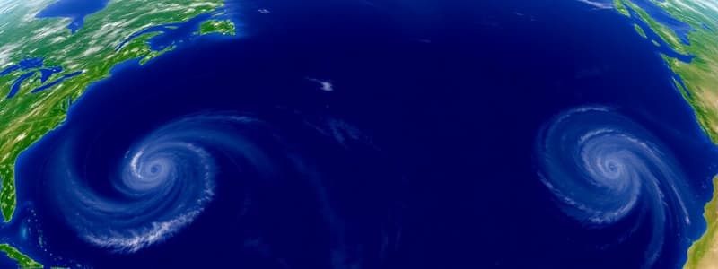
- Mid-latitude cyclones, also known as frontal depressions or extra-tropical cyclones, significantly affect climate and weather in temperate regions.
- These cyclones form between 30° and 60° latitudes, both north and south of the equator.
- They form predominantly at the polar front, where cold polar easterlies meet warm tropical westerlies.
- Formation requires a collision between warm and cold air masses, creating temperature and pressure imbalances.
- They are characterized by a low-pressure center, with cold and warm fronts forming a 'comma-shaped' pattern.
- They move from west to east, steered by prevailing westerlies.
Stages of Development:
- Initial: Warm and cold air masses interact without mixing, forming a stationary polar front.
- Development: A wave forms along the polar front, creating distinct warm and cold fronts.
- Mature: The cyclone intensifies, with well-developed cold and warm sectors.
- Occlusion: The cold front catches up with the warm front, lifting the warm air aloft and forming an occluded front.
- The advancing cold front leads to thunderstorms and a temperature drop.
- The warm front is associated with milder weather and precipitation.
- Occluded fronts feature combined elements of warm and cold front conditions leading to complex weather patterns.
- Cold fronts bring rapidly falling temperatures, thunderstorms, and clear skies post-passage.
- Warm fronts bring gradual temperature increases, prolonged rain or drizzle, and overcast skies.
- These cyclones affect agriculture, transportation, and energy consumption which can causes floods and storms.
- Natural disasters impact economies and livelihoods.
- Cyclones influence ecosystems, water cycles, and climate patterns.
- Forecasting and early warning systems help minimize damage and prepare communities.
- Infrastructure adaptations, like flood defenses and building regulations, help withstand adverse weather.
- Emergency planning and community education enhance resilience to cyclone-related hazards.
- These cyclones are identified on synoptic weather maps by their frontal symbols and pressure patterns.
- Cloud patterns on satellite images help track the cyclone’s development and movement.
- Governments and the private sector use GIS and weather prediction models to mitigate risks and plan activities.
Tropical Cyclones
- These storms arise over warm ocean waters between 5° and 30° North and South.
- They're characterized by intense low-pressure centers, high winds, and heavy rain.
- These systems are distinguished by their lack of fronts and symmetrical shape.
- The Coriolis effect influences cyclonic rotation.
- Warm core differentiates them from mid-latitude cyclones.
- Formation requires sea surface temperatures exceeding 26.5°C which provides water vapor to fuel the storm.
- In the North Atlantic and Northeast Pacific, they are hurricanes
- In the Northwest Pacific, they are typhoons.
- In the South Pacific and Indian Ocean, they are simply cyclones.
- Formation occurs away from the equator because the Coriolis force is needed for rotational development.
- Sea surface temperatures (SSTs) are essential for providing latent heat energy.
- Atmospheric instability is needed for warm air to rise, cool, and condense into clouds.
- Moisture in the mid-troposphere is essential for sustaining cloud formations.
- Low wind shear is needed as high levels of wind shear can disrupt the cyclone’s structure.
- The Coriolis Effect is needed for rotation of the storm and rarely forms within 5° of the equator.
Tropical cyclone stages of development:
- Formative: Disorganized clusters of clouds and thunderstorms.
- Tropical Depression: Defined circulation with maximum sustained winds of under 39 mph.
- Tropical Storm: Organized system with sustained winds from 39 to 73 mph.
- Hurricane/Typhoon/Cyclone: Fully developed system with sustained winds exceeding 74 mph.
- They bring torrential rain, high winds, thunderstorms, and storm surges.
- The system’s structure includes the eye (calm center), eyewall (intense storms), and rainbands (spiraling bands).
- Warm, moist air rises in the eyewall, leading to cloud formation and precipitation.
- The eye is warmer and clearer due to descending air.
- They cause property destruction, loss of life, economic disruption, and long-term environmental damage.
- Agricultural, infrastructural, and ecological damages are common.
- Effective management involves early warning systems, evacuation plans, and public education.
- Building codes are designed to withstand cyclone conditions.
- Post-event strategies focus on rapid response, recovery, and rebuilding efforts.
- Identified by circular cloud patterns, lack of fronts, and an intense center on weather maps and satellite images.
Subtropical Anticyclones
- Subtropical anticyclones influence weather patterns in the mid-latitudes, including South Africa.
- Subsiding air warms adiabatically, leading to stable, dry conditions and clear skies.
- South Atlantic High-Pressure Cell (SAHPC) influences South Africa's west coast, bringing dry conditions.
- The SAHPC impacts ocean currents, contributing to the cold Benguela Current.
- South Indian High-Pressure Cell (SIHPC) impacts the eastern coast of South Africa.
- The SIHPC brings moisture-laden winds, contributing to rainfall, especially during winter.
- Kalahari High-Pressure Cell (KHPC) primarily affects the interior plateau.
- The KHPC is most influential during winter, leading to clear, dry conditions and cold nights.
- High-pressure cells are associated with descending air, discouraging cloud formation and precipitation.
- Anticyclone positions and intensities shift with the seasons.
- Cells are characterized by mild to warm temperatures during the day and cooler temperatures at night.
- Winds flow outward and clockwise due to the Coriolis effect in the Southern Hemisphere.
- The interplay between high-pressure systems and local topography significantly influences South Africa's weather.
- The KHPC leads to dry, stable conditions inland during the winter.
- The SAHPC and SIHPC influence coastal weather, leading to rainfall disparities.
- The weakening of the KHPC allows for more humid, convective weather inland during the summer.
- The SAHPC and SIHPC can guide moisture-laden air towards the coast, affecting summer rainfall patterns.
- Moisture fronts and line thunderstorms develop when warm, moist air meets cooler, drier air.
- Coastal low-pressure systems can form under the influence of anticyclones.
- Berg winds are hot, dry downslope winds occurring when high pressure dominates the interior.
- Variability in rainfall caused by these can affect crop yields.
- Dry conditions can lead to water shortages.
- Berg winds and line thunderstorms can lead to increased fire risks and flash flooding.
- Water-saving measures and water storage infrastructure are needed.
- Drought-resistant crops and irrigation techniques that conserve water are used.
- Early warning systems and response plans are needed for severe weather.
- Anticyclones are identified by closed isobars depicting high pressure on synoptic charts.
- Moving disturbances such as fronts and low-pressure troughs can also be identified.
Valley Climates
- Valley climates exhibit unique weather patterns due to their geographical features.
- Slope orientation, local wind patterns, and temperature variations influence these climates.
- Slope aspect is the direction a slope faces relative to the sun.
- North-facing slopes receive more direct sunlightleading to warmer temperatures compared to south-facing slopes in the Southern Hemisphere.
- Warm, upward-moving anabatic winds occur during the day as the sun heats the valley sides.
- Cold, downward-moving katabatic winds occur at night as the valley sides cool.
- Temperature inversions occur when air temperature increases with height.
- Thermal belts are warmer zones situated between colder air below and above.
- Frost pockets form in lower parts of a valley where cold air settles.
- Radiation fog results from rapid nighttime cooling, reducing visibility.
- Settlement locations are chosen on warmer, sunnier slopes or within thermal belts.
- Crop types, placement, and productivity are influenced by microclimate conditions.
- Understanding valley climates is crucial for environmental conservation and managing air quality.
- Farmers select crop types and planting locations based on microclimates within valleys.
- Communities plan settlements to take advantage of thermal belts, avoiding cold air pooling.
- Strategies are implemented to reduce air pollution trapped by temperature inversions.
Urban Climates
- Urban climates are characterized by higher temperatures, reduced wind speeds, and increased pollution.
- Differences arise from artificial materials, high energy consumption, and dense building arrangements.
- Urban Heat Islands refer to urban areas warmer than surrounding rural areas.
- Urban surfaces absorb and retain more heat than natural landscapes.
- Energy usage releases significant amounts of heat.
- Urban areas have less vegetation, reducing cooling effects.
- High buildings and narrow streets trap heat and reduce air circulation.
- Increase in energy consumption for cooling and higher maintenance costs for infrastructure
- Increased heat-related illnesses and discomfort
- Altered microclimates, contributing to the decline of urban biodiversity, and increased air conditioning leads to higher greenhouse gas emissions.
- Strategies include increasing urban greenery, implementing reflective roofing, and enhancing urban planning.
- Pollution domes are layers of polluted air trapped over urban areas.
- High levels of pollutants from vehicles, industries, and domestic heating emissions contribute to pollution domes.
- Temperature inversions prevent dispersion of pollutants.
- Urban structures inhibit airflow, preventing dispersal of pollutants.
- Pollution domes have various economic, social, and environmental effects.
- Reduced quality of life and health problems result from pollution domes.
- Strategies include enhancing public transportation, enforcing stricter pollution controls, and developing green belts.
- Integration involves collaboration between city planners, government authorities, and the community.
Interpretation of Synoptic Weather Maps
- This is a fundamental skill in meteorology for current and future weather conditions.
- Involves understanding international symbols, high and low-pressure cells, station models, and satellite images.
- International symbols represent temperature, cloud cover, wind, precipitation, and atmospheric pressure.
- High-Pressure Cells (Anticyclones) lead to clear skies represented by closed isobars with higher pressure.
- Low-Pressure Cells (Cyclones) result in cloud formation and are represented by closed isobars with lower pressure.
- High-Pressure Cells bring dry, clear weather with light winds circulating clockwise in the Southern Hemisphere and counterclockwise in the Northern Hemisphere.
- Low-Pressure Cells are associated with stormy weather, strong winds, and precipitation, with winds circulating counterclockwise in the Southern Hemisphere and clockwise in the Northern Hemisphere.
- Station models represent weather conditions at various locations.
- Satellite images provide visual data on cloud cover and storm systems for a broader view.
- Isobars are lines connecting points of equal atmospheric pressure; closer isobars equal stronger winds.
- Fronts are represented by symbols indicating cold, warm, occluded, and stationary fronts.
- Weather symbols indicate specific conditions such as sunny, cloudy, rainy, or snowy.
- Wind arrows show wind direction and speed, with longer arrows indicating stronger winds.
- Comparison helps validate data and provides a comprehensive weather view on the map.
- Satellite images showing cloud cover can confirm the approach of a low-pressure system.
- Clear satellite images can confirm a the presence of a high-pressure system and fair weather conditions.
Studying That Suits You
Use AI to generate personalized quizzes and flashcards to suit your learning preferences.