Podcast
Questions and Answers
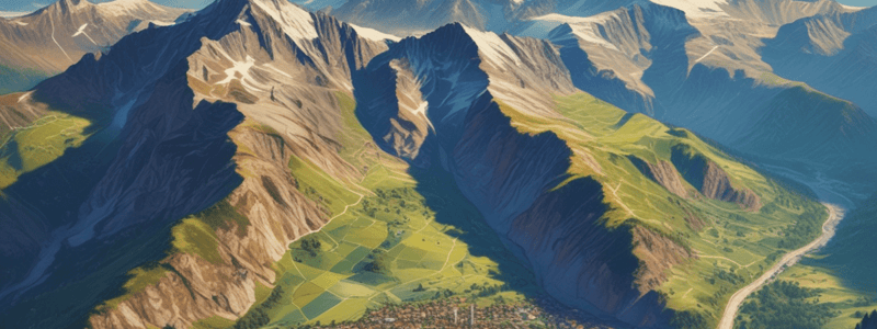
What type of geographic feature is the long chain of mountains on the far side of the picture?
What type of geographic feature is the long chain of mountains on the far side of the picture?
- Valley
- Plateau
- Ridge (correct)
- Escarpment
What is the term used to describe the relatively flat area on either side of the river?
What is the term used to describe the relatively flat area on either side of the river?
- Outwash plain
- Alluvial fan
- Alluvial plain
- Flood plain (correct)
What is the likely reason the people chose this location for their settlement?
What is the likely reason the people chose this location for their settlement?
- The location was on a high plateau
- The steep slopes were easy to build on
- The area was prone to flooding
- The river provided a reliable water source (correct)
What is the term used to describe the comparison of a site to its surroundings?
What is the term used to describe the comparison of a site to its surroundings?
What is the likely reason the far side ridge appears steeper than the near side?
What is the likely reason the far side ridge appears steeper than the near side?
What type of vegetation would you expect to find growing along the river banks?
What type of vegetation would you expect to find growing along the river banks?
What is the likely purpose of the flat, flood-prone areas on either side of the river?
What is the likely purpose of the flat, flood-prone areas on either side of the river?
What is the main reason Pensacola is considered a good site for a settlement?
What is the main reason Pensacola is considered a good site for a settlement?
What type of map is used to show the location of Pensacola in the United States?
What type of map is used to show the location of Pensacola in the United States?
Why is the peninsula separating Escambia Bay and East Bay not considered a headland?
Why is the peninsula separating Escambia Bay and East Bay not considered a headland?
What is the purpose of the black lines with little marks through them on the Pensacola map?
What is the purpose of the black lines with little marks through them on the Pensacola map?
What is the significance of the Cumberland Plateau in relation to Pensacola?
What is the significance of the Cumberland Plateau in relation to Pensacola?
What is the purpose of the blue lines on the Pensacola map?
What is the purpose of the blue lines on the Pensacola map?
What is the relationship between the river that ends in Pensacola and the mountains to the north?
What is the relationship between the river that ends in Pensacola and the mountains to the north?
What is the significance of the railroads near Pensacola?
What is the significance of the railroads near Pensacola?
Flashcards are hidden until you start studying


