Podcast
Questions and Answers
Match the organizations with their primary function:
Match the organizations with their primary function:
Department of the Interior = Manages and protects federal lands and natural resources U.S. Geological Survey = Provides scientific information about the Earth, its natural resources, and natural hazards The National Atlas = Provides comprehensive mapping and geographic information Reston, Virginia = Location of a U.S. Geological Survey office
Match the element of a bibliographic entry to its description:
Match the element of a bibliographic entry to its description:
Title = The name of the document Author = The person or entity responsible for the document Publisher = The organization that produced and distributed the document Date = The year the document was published
Match the term with its geographic context:
Match the term with its geographic context:
United States of America = The country to which the National Atlas refers Reston, Virginia = The city where the U.S. Geological Survey office is located Federal Lands = Lands managed and protected by the Department of Interior Earth = The planet studied by the U.S. Geological Survey
Match the term with its function within the document production:
Match the term with its function within the document production:
Match the role with the resources they would use to improve their understanding of US geography:
Match the role with the resources they would use to improve their understanding of US geography:
Match the data type with the organization most likely to generate it:
Match the data type with the organization most likely to generate it:
Match the function with the resource that provides it:
Match the function with the resource that provides it:
Match the entity with the type of hazard information it might provide:
Match the entity with the type of hazard information it might provide:
Match the entity with an aspect of natural resource management:
Match the entity with an aspect of natural resource management:
Match the action with the entity most likely to perform it:
Match the action with the entity most likely to perform it:
Match the following states with their abbreviations as shown on the map:
Match the following states with their abbreviations as shown on the map:
Match the following cities with the interstates that appear to pass closest to them:
Match the following cities with the interstates that appear to pass closest to them:
Match the state to the capital city shown on the map:
Match the state to the capital city shown on the map:
Match the following states to their relative direction according to the map:
Match the following states to their relative direction according to the map:
Match the city to the lake that is closest to it:
Match the city to the lake that is closest to it:
Match the state with a neighboring state, according to the map:
Match the state with a neighboring state, according to the map:
Match each city with its approximate location relative to a major river:
Match each city with its approximate location relative to a major river:
Match the following Midwestern states with their capitals:
Match the following Midwestern states with their capitals:
Match coastal states with their location on the map?
Match coastal states with their location on the map?
Match each of the following states with the time zone they are primarily in:
Match each of the following states with the time zone they are primarily in:
Flashcards
U.S. Geological Survey (USGS)
U.S. Geological Survey (USGS)
A U.S. government agency focused on science and research related to the Earth, its resources, and natural hazards.
Department of the Interior
Department of the Interior
A cabinet-level department of the U.S. government responsible for managing and protecting federal lands and natural resources.
National Atlas of the United States of America
National Atlas of the United States of America
A comprehensive collection of maps providing geographic, cultural, and historical information about the USA.
Reston, Virginia
Reston, Virginia
Signup and view all the flashcards
PDF
Signup and view all the flashcards
Washington State
Washington State
Signup and view all the flashcards
Idaho
Idaho
Signup and view all the flashcards
Minnesota
Minnesota
Signup and view all the flashcards
Wisconsin
Wisconsin
Signup and view all the flashcards
Nebraska
Nebraska
Signup and view all the flashcards
Iowa
Iowa
Signup and view all the flashcards
Colorado
Colorado
Signup and view all the flashcards
Oklahoma
Oklahoma
Signup and view all the flashcards
Louisiana
Louisiana
Signup and view all the flashcards
Georgia
Georgia
Signup and view all the flashcards
Study Notes
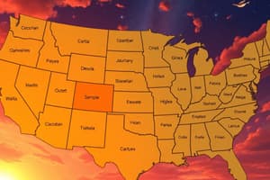
- This map provides a general reference of the United States
Geographic Regions
- The map includes the geographic regions of the United States, labeling states, major cities, and physical features.
- The map includes Alaska and Hawaii as insets due to their non-contiguous location.
- Canada borders the U.S. to the north.
- Mexico borders the U.S. to the south.
- The Atlantic Ocean is to the east of the U.S.
- The Pacific Ocean is to the west of the U.S.
- The Gulf of Mexico lies to the southeast of the U.S.
- The Bahamas and Cuba are islands located southeast of Florida.
States and Capitals
- Washington: Olympia
- Oregon: Salem
- California: Sacramento
- Nevada: Carson City
- Idaho: Boise
- Montana: Helena
- Wyoming: Cheyenne
- Utah: Salt Lake City
- Arizona: Phoenix
- New Mexico: Santa Fe
- Colorado: Denver
- North Dakota: Bismarck
- South Dakota: Pierre
- Nebraska: Lincoln
- Kansas: Topeka
- Oklahoma: Oklahoma City
- Texas: Austin
- Minnesota: St. Paul
- Iowa: Des Moines
- Missouri: Jefferson City
- Arkansas: Little Rock
- Louisiana: Baton Rouge
- Wisconsin: Madison
- Illinois: Springfield
- Indiana: Indianapolis
- Kentucky: Frankfort
- Tennessee: Nashville
- Mississippi: Jackson
- Alabama: Montgomery
- Michigan: Lansing
- Ohio: Columbus
- West Virginia: Charleston
- Virginia: Richmond
- North Carolina: Raleigh
- South Carolina: Columbia
- Georgia: Atlanta
- Florida: Tallahassee
- Pennsylvania: Harrisburg
- New York: Albany
- Vermont: Montpelier
- New Hampshire: Concord
- Maine: Augusta
- Massachusetts: Boston
- Connecticut: Hartford
- Rhode Island: Providence
- New Jersey: Trenton
- Delaware: Dover
- Maryland: Annapolis
Major Cities
- Seattle, Washington
- Spokane, Washington
- Portland, Oregon
- Eugene, Oregon
- Missoula, Montana
- Billings, Montana
- Great Falls, Montana
- Reno, Navada
- Sacramento, California
- San Fransisco, California
- Oakland, California
- San Jose, California
- Fresno, California
- Bakersfield, California
- Los Angeles, California
- San Bernadino, California
- San Diego, California
- Las Vegas, Nevada
- Pocatello, Idaho
- Casper, Wyoming
- Fort Collins, Colorado
- Pueblo, Colorado
- Provo, Utah
- Flagstaff, Arizona
- Albuquerque, New Mexico
- Roswell, New Mexico
- Tucson, Arizona
- Honolulu, Hawaii
- Hilo, Hawaii
- Fairbanks, Alaska
- Anchorage, Alaska
- Grand Forks, North Dakota
- Fargo, North Dakota
- Duluth, Minnesota
- Minneapolis, Minnesota
- St. Paul, Minnesota
- Sioux Falls, South Dakota
- Sioux City, Iowa
- Omaha, Nebraska
- Kansas City, Missouri
- Wichita, Kansas
- Tulsa, Oklahoma
- Amarillo, Texas
- Lubbock, Texas
- Fort Worth, Texas
- Dallas, Texas
- Shreveport, Louisiana
- San Antonio, Texas
- Houston, Texas
- Green Bay, Wisconsin
- Milwaukee, Wisconsin
- Cedar Rapids, Iowa
- Chicago, Illinois
- Peoria, Illinois
- St. Louis, Missouri
- Springfield, Missouri
- Fort Smith, Arkansas
- Memphis, Tennessee
- Knoxville, Tennessee
- Birmingham, Alabama
- Mobile, Alabama
- Biloxi, Mississippi
- New Orleans, Louisiana
- Grand Rapids, Michigan
- Detroit, Michigan
- Toledo, Ohio
- Fort Wayne, Indiana
- Evansville, Indiana
- Louisville, Kentucky
- Lexington, Kentucky
- Cincinnati, Ohio
- Pittsburgh, Pennsylvania
- Cleveland, Ohio
- Syracuse, New York
- Buffalo, New York
- Scranton, Pennsylvania
- Philadelphia, Pennsylvania
- Baltimore, Maryland
- Washington D.C.
- Norfolk, Virginia
- Virginia Beach, Virginia
- Greensboro, North Carolina
- Charlotte, North Carolina
- Greenville, South Carolina
- Macon, Georgia
- Columbus, Georgia
- Savannah, Georgia
- Wilmington, North Carolina
- Charleston, South Carolina
- Jacksonville, Florida
- Orlando, Florida
- Tampa, Florida
- Miami, Florida
- Bangor, Maine
- Burlington, Vermont
- Boston, Massachusetts
- Springfield, Massachusetts
- Portland, Maine
- Hartford, Connecticut
- Providence, Rhode Island
- New York, New York
- Trenton, New Jersey
- Dover, Delaware
Physical Features
- Pacific Ocean
- Atlantic Ocean
- Gulf of Mexico
- Great Salt Lake
- Colorado River
- Rio Grande River
- Yukon River
- Missouri River
- Mississippi River
- Arkansas River
- Red River
- Lake Superior
- Lake Michigan
- Lake Huron
- Lake Erie
- Lake Ontario
- Okeechobee
- Gulf of Alaska
- Bering Sea
- Brooks Range
- Alaska Range
- The Bahamas
- Cuba
Highways
- I-5
- I-10
- I-15
- I-20
- I-25
- I-27
- I-29
- I-30
- I-35
- I-40
- I-45
- I-55
- I-59
- I-64
- I-65
- I-70
- I-75
- I-80
- I-81
- I-84
- I-85
- I-87
- I-90
- I-94
- I-95
Other
- Albers equal area projection
- U.S. Department of the Interior
- U.S. Geological Survey
- The National Atlas of the United States of America®
Studying That Suits You
Use AI to generate personalized quizzes and flashcards to suit your learning preferences.