Podcast
Questions and Answers
What is the first step when processing LiDAR data?
What is the first step when processing LiDAR data?
- Assessing gyro and accelerometer accuracy
- Combining GPS and IMU data
- Analyzing trajectory files
- Extracting raw data (correct)
What are trajectory files primarily used for in the LiDAR data processing?
What are trajectory files primarily used for in the LiDAR data processing?
- Displaying lidar point clouds
- Storing raw GPS data
- Integrating ground base station data
- Combining GPS location and attitude information (correct)
Which type of data needs to be processed alongside the GPS data?
Which type of data needs to be processed alongside the GPS data?
- Terrestrial survey data
- IMU data (correct)
- Ground base station data
- Laser point data
What does the pre-processing of raw data in LiDAR involve?
What does the pre-processing of raw data in LiDAR involve?
Why is it necessary to assess the accuracy of the gyro and accelerometer during LiDAR data processing?
Why is it necessary to assess the accuracy of the gyro and accelerometer during LiDAR data processing?
What type of information does the ground base station data provide in LiDAR processing?
What type of information does the ground base station data provide in LiDAR processing?
Which step follows the processing of GPS data in the LiDAR data workflow?
Which step follows the processing of GPS data in the LiDAR data workflow?
What is the main purpose of pre-processing LiDAR data?
What is the main purpose of pre-processing LiDAR data?
What is a primary benefit of using LiDAR technology?
What is a primary benefit of using LiDAR technology?
What additional information can be collected alongside LiDAR data?
What additional information can be collected alongside LiDAR data?
What is a limitation of passive imaging systems used with LiDAR?
What is a limitation of passive imaging systems used with LiDAR?
In what types of projects would LiDAR technology be notably beneficial?
In what types of projects would LiDAR technology be notably beneficial?
Why might breaklines not be needed when using LiDAR?
Why might breaklines not be needed when using LiDAR?
What can be indicated about mobile mapping systems?
What can be indicated about mobile mapping systems?
What factor impacts the effectiveness of passive imaging systems integrated with LiDAR?
What factor impacts the effectiveness of passive imaging systems integrated with LiDAR?
What is a cost benefit of combining multiple imaging systems with LiDAR?
What is a cost benefit of combining multiple imaging systems with LiDAR?
What average point sample spacing is typically required for flood plain mapping using LiDAR?
What average point sample spacing is typically required for flood plain mapping using LiDAR?
What horizontal accuracy is generally needed when mapping flood plains with LiDAR?
What horizontal accuracy is generally needed when mapping flood plains with LiDAR?
When might a higher point density be needed for LiDAR data collection?
When might a higher point density be needed for LiDAR data collection?
What is the typical range of point density required by electric utility companies using LiDAR?
What is the typical range of point density required by electric utility companies using LiDAR?
What type of aircraft is typically employed for the LiDAR collection process in utility mapping?
What type of aircraft is typically employed for the LiDAR collection process in utility mapping?
Which component is NOT part of the LiDAR collection sensor system?
Which component is NOT part of the LiDAR collection sensor system?
At what wavelengths does the LiDAR laser typically operate?
At what wavelengths does the LiDAR laser typically operate?
What role does the GPS play in LiDAR mapping systems?
What role does the GPS play in LiDAR mapping systems?
What is one key benefit of using a LiDAR system for mapping projects?
What is one key benefit of using a LiDAR system for mapping projects?
Which of the following collection methods is NOT mentioned as a type for LiDAR data collection?
Which of the following collection methods is NOT mentioned as a type for LiDAR data collection?
What is crucial to determine before starting a LiDAR project?
What is crucial to determine before starting a LiDAR project?
Which characteristic of LiDAR allows it to operate effectively in low-light conditions?
Which characteristic of LiDAR allows it to operate effectively in low-light conditions?
In what way is corridor mapping different when using LiDAR compared to county-wide mapping?
In what way is corridor mapping different when using LiDAR compared to county-wide mapping?
Why is it important to set project requirements before using LiDAR?
Why is it important to set project requirements before using LiDAR?
What type of mapping can LiDAR be used for?
What type of mapping can LiDAR be used for?
Which statement about LiDAR is true?
Which statement about LiDAR is true?
What must LiDAR providers do after repairing a LiDAR sensor?
What must LiDAR providers do after repairing a LiDAR sensor?
At how many different altitudes is system calibration typically performed for airborne LiDAR systems?
At how many different altitudes is system calibration typically performed for airborne LiDAR systems?
What is primarily corrected during a calibration flight?
What is primarily corrected during a calibration flight?
What does pitch slope error indicate during a LiDAR calibration?
What does pitch slope error indicate during a LiDAR calibration?
During a calibration flight, what visual representation indicates scan factor or torsion?
During a calibration flight, what visual representation indicates scan factor or torsion?
What type of error occurs when the distance from the sensor to the target object is incorrectly measured?
What type of error occurs when the distance from the sensor to the target object is incorrectly measured?
Which parameter is NOT typically corrected during the calibration process of a LiDAR system?
Which parameter is NOT typically corrected during the calibration process of a LiDAR system?
In the context of LiDAR calibration, why are opposing flight lines used?
In the context of LiDAR calibration, why are opposing flight lines used?
Flashcards are hidden until you start studying
Study Notes
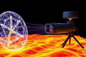
LiDAR Overview
- LiDAR is a powerful data collection system that captures 3D information about a defined area.
- LiDAR is useful for tasks like surface mapping, vegetation mapping, transportation route mapping, transmission route mapping, and 3D building mapping.
- LiDAR uses light waves that are invisible to the human eye.
- LiDAR systems can operate in dark conditions.
LiDAR Data Acquisition
- LiDAR data acquisition projects require planning to ensure optimal accuracy and data collection methods.
- Factors to consider include project goals, area size, and desired point density.
- LiDAR data can be collected using different methods: airborne, terrestrial, or mobile.
- The Federal Emergency Management Agency (FEMA) utilizes LiDAR for flood plain mapping.
- FEMA's projects often require point sample spacing of 1.4 meters with an accuracy of 0.5 meters horizontally and 15 to 18.5 centimeters vertically.
- Utility companies and engineering firms require higher point densities (20 to 40 points per meter) for precise power line mapping.
LiDAR Sensor Components
- LiDAR sensors are composed of a laser transceiver and receiver, GPS receiver, inertial measurement unit (IMU), and scanner.
- Lasers typically operate at wavelengths between 532 to 1550 nm, depending on the LiDAR system type.
- The GPS receiver tracks the sensor platform's location, while the IMU records attitude information.
LiDAR System Calibration
- LiDAR systems undergo calibration tests after any repairs or modifications.
- Airborne systems require extensive calibration flights conducted at various altitudes to ensure accuracy.
- Calibration involves analyzing differences between opposing flight lines to detect and correct errors.
- Common calibration corrections include roll, pitch, heading, range, pitch slope error, and scan factor or torsion.
Working with LiDAR Data
- LiDAR data processing involves extracting raw data from the system.
- Processing steps typically involve combining GPS and IMU data into trajectory files.
- Trajectory files contain GPS location and IMU attitude information.
- Data analysis involves verifying the accuracy of the IMU's gyro and accelerometer.
LiDAR Data Processing
- LiDAR data processing often involves similar steps across systems, but the techniques may vary depending on the provider.
- Raw data is extracted from the system, including laser data, positional data, base station data, GPS, and IMU data.
- Processing often starts with GPS data, followed by combining it with IMU data to create trajectory files containing location and attitude information.
- Accuracy of the IMU’s gyro and accelerometer is assessed during the processing stage.
LiDAR Capabilities
- LiDAR can capture data, including imagery, camera information, video imaging systems, multi-spectral and hyperspectral imaging systems.
- Mobile mapping systems usually include multiple cameras to capture information simultaneously.
- LiDAR systems can operate independently of light sources, making them suitable for nighttime operations, unlike passive systems.
- Breaklines are not always necessary when using LiDAR data.
- The need for breaklines depends on the specific product requirements.
Studying That Suits You
Use AI to generate personalized quizzes and flashcards to suit your learning preferences.