Podcast
Questions and Answers
How does 'Precision' relate to 'Accuracy' in surveying measurements?
How does 'Precision' relate to 'Accuracy' in surveying measurements?
- Precision goes one step further than accuracy by demanding that the words and data used are exact. (correct)
- Precision and accuracy are interchangeable terms in surveying; they both ensure reliability.
- Precision ensures the thinking is reliable, while accuracy demands exact words and data.
- Precision is achieved when all information is correct, while accuracy goes a step further to demand exactness.
What is the primary consideration for using Plan Surveying methods?
What is the primary consideration for using Plan Surveying methods?
- Accounting for the curvature of the earth's surface for high-precision measurements.
- Modeling and making measurements of the earth's shape based on 3D dimensions.
- Collecting, storing, and displaying raster images such as aerial and satellite imagery.
- Making measurements on the earth's surface using simple 3D Euclidean geometry, neglecting curvature. (correct)
What role does 'Geodesy' play in representing areas of interest?
What role does 'Geodesy' play in representing areas of interest?
- It relies on 2D plan shapes to represent areas of interest, simplifying complex geometries.
- It uses satellite navigation systems to allow users to determine their absolute position.
- It uses raster images, such as aerial and satellite imagery, to represent areas of interest.
- It serves as a foundation for mathematical models representing areas of interest. (correct)
Which statement accurately describes the application of Geographic Information Systems (GIS)?
Which statement accurately describes the application of Geographic Information Systems (GIS)?
How do 'Systematic errors' differ from 'Gross errors' in surveying measurements?
How do 'Systematic errors' differ from 'Gross errors' in surveying measurements?
Which of the following best describes the purpose of 'Remote Sensing' in the context of surveying?
Which of the following best describes the purpose of 'Remote Sensing' in the context of surveying?
What is the best way to manage 'Gross errors' during a surveying process?
What is the best way to manage 'Gross errors' during a surveying process?
When preparing for a surveying site visit with safety in mind, which action is most important?
When preparing for a surveying site visit with safety in mind, which action is most important?
Why is it important to understand the 'Earth Shape' in the context of surveying?
Why is it important to understand the 'Earth Shape' in the context of surveying?
What distinguishes 'Photogrammetry' from other surveying techniques?
What distinguishes 'Photogrammetry' from other surveying techniques?
A surveyor consistently records distances that are 2cm longer than the actual distance due to a miscalibrated tape measure. What type of error is this, and how should it be addressed?
A surveyor consistently records distances that are 2cm longer than the actual distance due to a miscalibrated tape measure. What type of error is this, and how should it be addressed?
When using GPS for surveying, coordinates are determined relative to which coordinate system?
When using GPS for surveying, coordinates are determined relative to which coordinate system?
If a surveyor mistakenly transposes digits when recording a measurement, what type of error has occurred, and what is the appropriate action to take?
If a surveyor mistakenly transposes digits when recording a measurement, what type of error has occurred, and what is the appropriate action to take?
Which of the following is the most accurate description of the 'Geoid'?
Which of the following is the most accurate description of the 'Geoid'?
For accurate angle measurements in surveying, which unit conversion is correct?
For accurate angle measurements in surveying, which unit conversion is correct?
In the context of Geodetic Reference Surfaces, what is the significance of the Equator and Greenwich Meridian?
In the context of Geodetic Reference Surfaces, what is the significance of the Equator and Greenwich Meridian?
Which of the following statements best describes the relationship between latitude, longitude and the Earth?
Which of the following statements best describes the relationship between latitude, longitude and the Earth?
How does 'Coordinate System' relate to 'Geodesy'?
How does 'Coordinate System' relate to 'Geodesy'?
In the process of obtaining information by photographing, what is the role of terrestrial, aerial, and satellite imagery in Photogrammetry?
In the process of obtaining information by photographing, what is the role of terrestrial, aerial, and satellite imagery in Photogrammetry?
What should be done when encountering temporary lighting requirements at the site?
What should be done when encountering temporary lighting requirements at the site?
What is the main difference between 'Projection' and 'Plan Surveying'?
What is the main difference between 'Projection' and 'Plan Surveying'?
Which conversion is right to represent a Distance Unit?
Which conversion is right to represent a Distance Unit?
In terms of units of measurement what is the amount that equals one degree?
In terms of units of measurement what is the amount that equals one degree?
How can an observer prevent gross errors?
How can an observer prevent gross errors?
Flashcards
Accuracy
Accuracy
Ensuring information is correct and free from error; reliable thinking.
Precision
Precision
Going a step further than accuracy; demanding exactness and completeness of data.
Accuracy (measurement)
Accuracy (measurement)
The closeness of measurements to the correct or accepted value.
Precision (measurement)
Precision (measurement)
Signup and view all the flashcards
Plan Surveying
Plan Surveying
Signup and view all the flashcards
Geodesy
Geodesy
Signup and view all the flashcards
Coordinate System
Coordinate System
Signup and view all the flashcards
Projection
Projection
Signup and view all the flashcards
GPS (Global Positioning System)
GPS (Global Positioning System)
Signup and view all the flashcards
Photogrammetry
Photogrammetry
Signup and view all the flashcards
Remote Sensing
Remote Sensing
Signup and view all the flashcards
GIS (Geographic Information Systems)
GIS (Geographic Information Systems)
Signup and view all the flashcards
Gross Errors
Gross Errors
Signup and view all the flashcards
Systematic Errors
Systematic Errors
Signup and view all the flashcards
Random Errors
Random Errors
Signup and view all the flashcards
Study Notes
Course Overview
- The material provides an introduction to surveying, covering concepts, definitions, earth shape, units, equipment, safety, and notes.
Syllabus
- The course will cover basics of surveying, distance measurements, leveling, angle measurements, surveying equipment, and an introduction to geoinformatics.
Student Work
- Student work accounts for 30% of the grade, including attendance, timely sheet delivery, quizzes, and lab work.
- A mid-term exam is worth 20%.
- The final exam is worth 50%.
Core Concepts
- Mathematics serves as the language of science, engineering, and technology.
- Science provides established facts and laws about the real world.
- Engineering is used for predicting future behavior of objects.
- Technology provides contemporary tools used to achieve goals.
Accuracy and Precision
- Accuracy ensures all information is correct and free from error.
- Precision goes a step further than accuracy, demanding that words and data used are exact, with no more details to be added.
Earth Shape
- Key parameters and definitions related to the WGS84 system are explored.
- The earth's center of mass is defined, with 'b' (semi-minor axis) measuring 6,356,752.314 m and 'a' (semi-major axis) measuring 6,378,137.000 m.
- Geodetic reference surfaces and horizontal datums are discussed, noting latitude originates from the Equator and longitude originates from Greenwich.
GNSS - Derived Ellipsoid Coordinates
- P(X, Y, Z) = P (φ, λ, h)
- φ is the geodetic latitude
- λ is the longitude
- h is the height above the ellipsoid
Units of Measurement
- Distance Units
- 1 meter is equal to 0.001KM, 100cm, and 1000mm.
- Time Units
- One hour equals 60 minutes or 3600 seconds.
- Angle Units
- One degree equals 60 minutes or 3600 seconds.
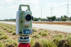
Surveying Types
- Plan Surveying: Measurements on earth's surface are based on 3D Euclidean geometry, and the curvature of the earth's surface is neglected.
- Geodesy: The science and engineering of modeling and making measurements of Earth's shape, considering 3D dimensions, time, geophysics, and geodynamics.
- Coordinate System: A mathematical model represents the area of interest based on geodesy.
- Projection: The mathematical transformation of a 3D shape into a 2D plan shape.
- GPS (Global Positioning System): A satellite navigation system that allows users to determine their absolute position relative to the WGS84 coordinate system using GPS receivers.
- Photogrammetry: The process of obtaining information about an object by photographing it and measuring the photographs, with data collected from terrestrial, aerial, and satellite imagery.
- Remote Sensing: Collecting, storing, manipulating, and displaying raster images, such as aerial and satellite images.
- GIS (Geographic Information Systems): Decision support systems with advanced capabilities for capturing, storing, checking, manipulating, analyzing, and displaying geographically located data.
Types of Errors in Surveying
- Gross Errors: Mistakes due to the carelessness of the observer; these must be detected and eliminated before measurements can be used.
- Systematic Errors: Follow a pattern and can be expressed by functional relationships. They should be removed from measurements by applying necessary corrections.
- Random Errors/Accidental Errors: Treated using probability models.
Safety in Surveying
- Plan the trip to the site; ensure all equipment is in good working condition and that batteries and power sources are ready.
- Obtain legal entry to sites and protect the environment.
- Use gloves, respirators or face masks, safety helmets, ear defenders, eye protection, boots, and temporary lighting.
- Be aware of existing landmarks and new control points.
Student Notes
- Sheet 1 delivery is required for each section
- Quizzes are in each section
Studying That Suits You
Use AI to generate personalized quizzes and flashcards to suit your learning preferences.