Podcast
Questions and Answers
What is one reason why maps are important?
What is one reason why maps are important?
- They help us find our way to destinations. (correct)
- They are only used for scenic routes.
- They can be used as a decoration.
- They show only historical locations.
Maps are only used to identify flat areas of land.
Maps are only used to identify flat areas of land.
False (B)
Name one flat location in Jamaica.
Name one flat location in Jamaica.
example answer: Kingston
Maps can help us find the best way to _____ or shop.
Maps can help us find the best way to _____ or shop.
Match the following features of maps with their functions:
Match the following features of maps with their functions:
What is the primary purpose of a map?
What is the primary purpose of a map?
Paper maps are dependent on battery power.
Paper maps are dependent on battery power.
What type of view does a map typically provide?
What type of view does a map typically provide?
The capital of St. Elizabeth is __________.
The capital of St. Elizabeth is __________.
Which of the following is NOT an importance of maps?
Which of the following is NOT an importance of maps?
Match the map features with their descriptions:
Match the map features with their descriptions:
What is used on maps to represent features found on the ground?
What is used on maps to represent features found on the ground?
Port Antonio is the capital of __________.
Port Antonio is the capital of __________.
What type of map would you use to find out the boundaries of different countries?
What type of map would you use to find out the boundaries of different countries?
Topographic maps show elevation and landforms using contour lines.
Topographic maps show elevation and landforms using contour lines.
What do population maps typically show?
What do population maps typically show?
A map that displays various types of rocks in an area is called a ______ map.
A map that displays various types of rocks in an area is called a ______ map.
Choropleth maps are used primarily to indicate which of the following?
Choropleth maps are used primarily to indicate which of the following?
Match the following types of maps with what they represent:
Match the following types of maps with what they represent:
Dot maps use shading to represent population density.
Dot maps use shading to represent population density.
What do climate maps show?
What do climate maps show?
Which type of map shows the locations of rivers and mountains?
Which type of map shows the locations of rivers and mountains?
Choropleth maps are used to show types of rocks in a region.
Choropleth maps are used to show types of rocks in a region.
Name one feature that can be found on a map.
Name one feature that can be found on a map.
A __________ map shows rainfall and temperature of an area.
A __________ map shows rainfall and temperature of an area.
What type of map showcases where people live in a region?
What type of map showcases where people live in a region?
Match the following maps with their primary purpose:
Match the following maps with their primary purpose:
Maps can provide pictorial representations of physical geography.
Maps can provide pictorial representations of physical geography.
What are two types of maps that categorize geographic information?
What are two types of maps that categorize geographic information?
Flashcards
Purpose of maps
Purpose of maps
Maps help us locate places, find routes, and understand the terrain.
Map features: terrain
Map features: terrain
Maps can show how steep or flat the land is, providing information about the landscape.
Map use: finding destinations
Map use: finding destinations
Maps are useful for finding the quickest and easiest ways to reach places such as a friend's home or a holiday spot.
Map components
Map components
Signup and view all the flashcards
Importance of maps
Importance of maps
Signup and view all the flashcards
Map definition
Map definition
Signup and view all the flashcards
Map purpose 1
Map purpose 1
Signup and view all the flashcards
Map purpose 2
Map purpose 2
Signup and view all the flashcards
Map scale
Map scale
Signup and view all the flashcards
Types of maps (ex)
Types of maps (ex)
Signup and view all the flashcards
Map use vs GPS
Map use vs GPS
Signup and view all the flashcards
Map symbols
Map symbols
Signup and view all the flashcards
Map drawing
Map drawing
Signup and view all the flashcards
What are physical maps?
What are physical maps?
Signup and view all the flashcards
What information do political maps show?
What information do political maps show?
Signup and view all the flashcards
What is a population map?
What is a population map?
Signup and view all the flashcards
What do climate maps show?
What do climate maps show?
Signup and view all the flashcards
What are topographic maps used for?
What are topographic maps used for?
Signup and view all the flashcards
What information do geological maps display?
What information do geological maps display?
Signup and view all the flashcards
How does a choropleth map represent population?
How does a choropleth map represent population?
Signup and view all the flashcards
How does a dot map illustrate population?
How does a dot map illustrate population?
Signup and view all the flashcards
Topographic Map
Topographic Map
Signup and view all the flashcards
Physical Map
Physical Map
Signup and view all the flashcards
Geological Map
Geological Map
Signup and view all the flashcards
Population Density Map
Population Density Map
Signup and view all the flashcards
Climate Map
Climate Map
Signup and view all the flashcards
Map Features
Map Features
Signup and view all the flashcards
What map shows rock types?
What map shows rock types?
Signup and view all the flashcards
Which map shows where people live?
Which map shows where people live?
Signup and view all the flashcards
Study Notes
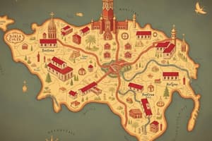
What is a Map?
- A map is a graphic representation of a portion of the Earth's surface, displayed on paper or digitally.
- It is drawn to scale, providing a reduced representation of the real world.
- Maps are drawn as if viewed directly from above (bird's eye view).
- Maps use colors, symbols, and abbreviations to represent and simplify features on the ground.
Lesson Objectives
- Define the term "map".
- Identify three important uses of maps.
Map vs. GPS
- Paper maps do not require batteries.
- Paper maps can be easier to use in fieldwork settings and classrooms.
- Paper maps enhance spatial awareness.
Why are Maps Important?
- Maps provide information on locations and help people navigate.
- Maps show features and amenities within an area.
- Maps can help determine land terrain (steepness or flatness).
- Maps facilitate navigation to destinations (e.g., friends' houses, schools, shops, holiday destinations).
Checkpoint Questions
- A map should include the following:
- Graphic representation.
- Scale.
- Bird's eye view perspective.
- To convince someone of the importance of maps, describe their uses as tools of navigation, providing information, showing locations, displaying features in an area and describing land terrain.
Studying That Suits You
Use AI to generate personalized quizzes and flashcards to suit your learning preferences.