Podcast
Questions and Answers
Which of these best describes the term "topography" in geography?
Which of these best describes the term "topography" in geography?
- The detailed description of the Earth's surface features and their relief (correct)
- The investigation of the Earth's internal structure and its geological processes
- The analysis of the Earth's population and its distribution
- The study of the Earth's atmosphere and its weather patterns
What is the primary function of contour lines on a topographic map?
What is the primary function of contour lines on a topographic map?
- To depict the distribution of vegetation and soil types
- To indicate the location of major cities and towns
- To represent the shape and elevation of the land surface (correct)
- To show the direction and density of human settlements
Which of the following is NOT a component of topography?
Which of the following is NOT a component of topography?
- Weather patterns (correct)
- Drainage patterns
- Relief
- Landforms
Which of the following BEST describes the "aspect" of a slope?
Which of the following BEST describes the "aspect" of a slope?
How does the contour interval on a topographic map impact the interpretation of terrain?
How does the contour interval on a topographic map impact the interpretation of terrain?
Which of the following techniques is NOT directly used in topographical surveying and mapping?
Which of the following techniques is NOT directly used in topographical surveying and mapping?
What is the significance of understanding drainage patterns in topography?
What is the significance of understanding drainage patterns in topography?
How do topographic maps differ from typical road maps?
How do topographic maps differ from typical road maps?
Which of these is an example of a landform?
Which of these is an example of a landform?
What is the primary advantage of using remote sensing techniques in topographical analysis?
What is the primary advantage of using remote sensing techniques in topographical analysis?
What is the primary purpose of LiDAR technology?
What is the primary purpose of LiDAR technology?
Which of the following aspects is NOT significantly influenced by topography?
Which of the following aspects is NOT significantly influenced by topography?
How does GIS enhance our understanding of topography?
How does GIS enhance our understanding of topography?
What role does knowledge of topography play in understanding natural hazards?
What role does knowledge of topography play in understanding natural hazards?
Why is topography important for resource management?
Why is topography important for resource management?
In what way does topography impact urban planning?
In what way does topography impact urban planning?
Which of the following is a key function of GIS in relation to topographic data?
Which of the following is a key function of GIS in relation to topographic data?
What is one of the significant uses of topography in environmental studies?
What is one of the significant uses of topography in environmental studies?
How does topography affect engineering design projects?
How does topography affect engineering design projects?
Which statement about LiDAR is accurate?
Which statement about LiDAR is accurate?
Flashcards
Geography
Geography
The study of Earth's surface, encompassing its physical features, climate, population, and resources.
Topography
Topography
A branch of geography focusing on the detailed description of Earth's surface, including features like mountains, valleys, and plains.
Relief
Relief
The vertical variations on Earth's surface, including altitudes, slopes, and aspects (slope direction).
Landforms
Landforms
Signup and view all the flashcards
Drainage Pattern
Drainage Pattern
Signup and view all the flashcards
Slope
Slope
Signup and view all the flashcards
Aspect
Aspect
Signup and view all the flashcards
Contours
Contours
Signup and view all the flashcards
Topographic Maps
Topographic Maps
Signup and view all the flashcards
GPS (Global Positioning System)
GPS (Global Positioning System)
Signup and view all the flashcards
What is LiDAR?
What is LiDAR?
Signup and view all the flashcards
What is GIS?
What is GIS?
Signup and view all the flashcards
What is data integration in GIS?
What is data integration in GIS?
Signup and view all the flashcards
What is spatial analysis in GIS?
What is spatial analysis in GIS?
Signup and view all the flashcards
How does topography influence natural hazards?
How does topography influence natural hazards?
Signup and view all the flashcards
How is topography important for environmental studies?
How is topography important for environmental studies?
Signup and view all the flashcards
How does topography impact urban planning?
How does topography impact urban planning?
Signup and view all the flashcards
How does topography influence resource management?
How does topography influence resource management?
Signup and view all the flashcards
How does topography affect engineering projects?
How does topography affect engineering projects?
Signup and view all the flashcards
How can LiDAR be used to study topography?
How can LiDAR be used to study topography?
Signup and view all the flashcards
Study Notes
Introduction to Geography and Topography
- Geography is the study of the Earth's surface, encompassing its physical features, climate, population, and resources. It integrates both human and physical aspects of the environment.
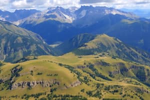
- Topography is a specialized branch of geography, focusing on detailed descriptions of the Earth's surface relief features, including mountains, valleys, plains, plateaus, and water bodies.
Components of Topography
- Relief: The vertical variations on Earth's surface, including altitudes, slopes, and aspect (slope direction).
- Landforms: Natural surface features like mountains, hills, valleys, plains, plateaus, canyons, and diverse river valley types.
- Drainage Patterns: The arrangement and characteristics of rivers, streams, and other water bodies, including tributaries and watersheds.
- Slope: The angle of inclination of the land surface. Steep slopes have high angles, while gentle slopes have low angles. Slopes are affected by geology and erosion/deposition processes.
- Aspect: The compass direction of a slope. Critical for influencing solar radiation, thereby impacting local climates, vegetation, and soil moisture.
- Contours: Lines on maps connecting points of equal elevation, depicting land shape and steepness. Contour intervals specify the elevation difference between adjacent contours, vital for mapping relief and understanding terrain.
Surveying and Mapping Techniques in Topography
- Topographic Maps: Visual representations of the Earth's surface, including elevation contours indicating land features. They utilize symbols and colors to show various features.
- GPS (Global Positioning System): A satellite-based navigation system providing precise Earth locations, crucial for real-time topographical surveys.
- Aerial Photography and Remote Sensing: Techniques employing aerial images and satellite data for detailed geographic area information (elevation, land cover, etc.). Useful for large-area mapping or rapid assessments when ground-based methods are impractical/expensive.
- LiDAR (Light Detection and Ranging): A remote sensing method using laser pulses to measure distances and map surface characteristics. Highly accurate for creating detailed 3D models.
Geographic Information Systems (GIS) and Topography
- GIS: A system for creating, storing, analyzing, and displaying geographic data, crucial for managing and interpreting topographical information.
- Data Integration: GIS tools combine data from diverse sources (elevation, land use, population) for comprehensive spatial analyses, important for geographic and environmental studies.
- Spatial Analysis: GIS allows for calculations of areas, volumes, and distances within topographic datasets to understand landform and feature spatial patterns.
Importance of Topography
- Understanding Natural Hazards: Topography influences natural hazard risks (landslides, floods, avalanches). Understanding slope angles, relief, and drainage patterns is critical for hazard prediction and mitigation strategies.
- Environmental Studies: Topography is essential for environmental studies (endangered habitats, water resources, flora/fauna distribution).
- Urban Planning: Topography significantly impacts city design, infrastructure (e.g., roads), and public transportation systems.
- Resource Management: Identifying and managing resources (like mineral deposits) often requires understanding topography and land features.
- Geographic and Engineering Design: Topography influences the cost and feasibility of engineering projects (dams, bridges, roads).
Studying That Suits You
Use AI to generate personalized quizzes and flashcards to suit your learning preferences.