Podcast
Questions and Answers
Which lake is near the source of the Indus river?
Which lake is near the source of the Indus river?
- Wular Lake
- Naini Lake
- Dal Lake
- Mansarovar Lake (correct)
What is the length of the Indus plain?
What is the length of the Indus plain?
- 3500 km
- 1500 km
- 2900 km (correct)
- 2500 km
Which of the following rivers merges with the Indus at Mithankot in Pakistan?
Which of the following rivers merges with the Indus at Mithankot in Pakistan?
- Krishna
- Godavari
- Yamuna
- Jhelum (correct)
Where does the Indus river emerge in Pakistan?
Where does the Indus river emerge in Pakistan?
What fraction of the Indus river flows through India?
What fraction of the Indus river flows through India?
Where does the Ganga River enter the plains?
Where does the Ganga River enter the plains?
Which river is a right-bank tributary of the Ganga?
Which river is a right-bank tributary of the Ganga?
What is the source of the Ganga River?
What is the source of the Ganga River?
Which tributary of the Ganga is known to contribute to flooding in the northern plains?
Which tributary of the Ganga is known to contribute to flooding in the northern plains?
Which of the following tributaries originates from the peninsular uplands?
Which of the following tributaries originates from the peninsular uplands?
What type of rivers in India are considered perennial?
What type of rivers in India are considered perennial?
Which of the following is a characteristic of Penninsular rivers?
Which of the following is a characteristic of Penninsular rivers?
Which river is an example of a Himalayan river?
Which river is an example of a Himalayan river?
What is a defining feature of the course of Himalayan rivers?
What is a defining feature of the course of Himalayan rivers?
Which statement regarding the drainage system in India is correct?
Which statement regarding the drainage system in India is correct?
Which of the following rivers is NOT a Penninsular river?
Which of the following rivers is NOT a Penninsular river?
How do Penninsular rivers typically differ from Himalayan rivers in volume?
How do Penninsular rivers typically differ from Himalayan rivers in volume?
What primarily controls the drainage systems in India?
What primarily controls the drainage systems in India?
What is the main flow direction of the Ganga River?
What is the main flow direction of the Ganga River?
What happens to the Ganga River at Farakha?
What happens to the Ganga River at Farakha?
Which river joins the Ganga River in Bangladesh?
Which river joins the Ganga River in Bangladesh?
What is the approximate length of the Ganga River?
What is the approximate length of the Ganga River?
What characterizes the plain formed between Ambala and Sunderban?
What characterizes the plain formed between Ambala and Sunderban?
What is the origin of the Brahmaputra River?
What is the origin of the Brahmaputra River?
Where does the Brahmaputra River primarily flow?
Where does the Brahmaputra River primarily flow?
Which rivers join the Brahmaputra in Arunachal Pradesh?
Which rivers join the Brahmaputra in Arunachal Pradesh?
How does the Brahmaputra River's sediment volume change as it flows from Tibet into India?
How does the Brahmaputra River's sediment volume change as it flows from Tibet into India?
What consequence does the large volume of water from the Brahmaputra in India lead to?
What consequence does the large volume of water from the Brahmaputra in India lead to?
What geographic feature serves as the main divide for the peninsular rivers?
What geographic feature serves as the main divide for the peninsular rivers?
Which of the following rivers does NOT flow eastward into the Bay of Bengal?
Which of the following rivers does NOT flow eastward into the Bay of Bengal?
What is the direction of flow for the rivers Mahanadi, Kaveri, and Krishna?
What is the direction of flow for the rivers Mahanadi, Kaveri, and Krishna?
Where do the streams flowing west of the Western Ghats ultimately lead?
Where do the streams flowing west of the Western Ghats ultimately lead?
Which statement regarding the Western Ghats is true?
Which statement regarding the Western Ghats is true?
Where does the Narmada River rise?
Where does the Narmada River rise?
What notable geographic feature is formed by the Narmada River near Jabalpur?
What notable geographic feature is formed by the Narmada River near Jabalpur?
Which of the following describes the tributaries of the Narmada River?
Which of the following describes the tributaries of the Narmada River?
What kind of scenic location does Dholakpur Falls represent?
What kind of scenic location does Dholakpur Falls represent?
What geological process is associated with the formation of the Narmada River's valley?
What geological process is associated with the formation of the Narmada River's valley?
Where does the Tapi River rise?
Where does the Tapi River rise?
Which states are covered by the Tapi River's drainage basin?
Which states are covered by the Tapi River's drainage basin?
What is the relationship between the Tapi River and the Narmada River?
What is the relationship between the Tapi River and the Narmada River?
Which of the following rivers is NOT an example of a river mentioned in relation to coastal plains?
Which of the following rivers is NOT an example of a river mentioned in relation to coastal plains?
Which geographic feature contributes to the shortness of the rivers located south of the Western Ghats?
Which geographic feature contributes to the shortness of the rivers located south of the Western Ghats?
What is the approximate length of the Godavari River?
What is the approximate length of the Godavari River?
In which district does the Godavari River originate?
In which district does the Godavari River originate?
Which of the following is a tributary of the Godavari River?
Which of the following is a tributary of the Godavari River?
What is the drainage basin of the Godavari River recognized as?
What is the drainage basin of the Godavari River recognized as?
Where does the Godavari River ultimately flow into?
Where does the Godavari River ultimately flow into?
Which states share the Mahanadi Basin?
Which states share the Mahanadi Basin?
From where does the Mahanadi River originate?
From where does the Mahanadi River originate?
In which body of water does the Mahanadi River empty?
In which body of water does the Mahanadi River empty?
Which of the following statements is true about the Mahanadi River?
Which of the following statements is true about the Mahanadi River?
Flashcards
Where does the Indus River originate?
Where does the Indus River originate?
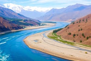
The Indus River originates in Tibet, near Lake Mansarovar. It flows westward, entering India in Ladakh, where it forms a picturesque gorge.
Name some tributaries of the Indus River.
Name some tributaries of the Indus River.
The tributaries of the Indus River are the Zaskar, Nubra, and Shyok. They join the Indus in the Kashmir region.
Where does the Indus River flow through in Kashmir?
Where does the Indus River flow through in Kashmir?
The Indus River flows through Baltistan and Gilgit in Kashmir, finally emerging at the Atock mountains.
Which rivers merge with the Indus at Mithankot?
Which rivers merge with the Indus at Mithankot?
Signup and view all the flashcards
What is the length of the Indus plain and what percentage is in India?
What is the length of the Indus plain and what percentage is in India?
Signup and view all the flashcards
Ganges River: Source
Ganges River: Source
Signup and view all the flashcards
Ganga Enters Plains
Ganga Enters Plains
Signup and view all the flashcards
Yamuna River
Yamuna River
Signup and view all the flashcards
Himalayan Tributaries
Himalayan Tributaries
Signup and view all the flashcards
Penninsular Tributaries
Penninsular Tributaries
Signup and view all the flashcards
Drainage systems and relief features
Drainage systems and relief features
Signup and view all the flashcards
Himalayan Rivers
Himalayan Rivers
Signup and view all the flashcards
Peninsular Rivers
Peninsular Rivers
Signup and view all the flashcards
Himalayan vs. Peninsular: length and silt
Himalayan vs. Peninsular: length and silt
Signup and view all the flashcards
Himalayan vs. Peninsular: course and slits
Himalayan vs. Peninsular: course and slits
Signup and view all the flashcards
Examples of Himalayan Rivers
Examples of Himalayan Rivers
Signup and view all the flashcards
Examples of Peninsular Rivers
Examples of Peninsular Rivers
Signup and view all the flashcards
Characteristics of Peninsular Rivers
Characteristics of Peninsular Rivers
Signup and view all the flashcards
Where does the Brahmaputra River originate?
Where does the Brahmaputra River originate?
Signup and view all the flashcards
How does the length of the Brahmaputra compare to the Indus?
How does the length of the Brahmaputra compare to the Indus?
Signup and view all the flashcards
Describe the Brahmaputra's journey through the Himalayas.
Describe the Brahmaputra's journey through the Himalayas.
Signup and view all the flashcards
Explain the Brahmaputra's sediment and volume in Tibet.
Explain the Brahmaputra's sediment and volume in Tibet.
Signup and view all the flashcards
Why does the Brahmaputra have a large volume and sediment in India?
Why does the Brahmaputra have a large volume and sediment in India?
Signup and view all the flashcards
What creates the main divide in Peninsular Rivers?
What creates the main divide in Peninsular Rivers?
Signup and view all the flashcards
Name three rivers flowing eastwards from the Western Ghats.
Name three rivers flowing eastwards from the Western Ghats.
Signup and view all the flashcards
What happens to rivers on the west side of the Western Ghats?
What happens to rivers on the west side of the Western Ghats?
Signup and view all the flashcards
What is the primary role of the Western Ghats in peninsular river systems?
What is the primary role of the Western Ghats in peninsular river systems?
Signup and view all the flashcards
What are the characteristics of Peninsular rivers?
What are the characteristics of Peninsular rivers?
Signup and view all the flashcards
Where is the northernmost point of Ganga Delta?
Where is the northernmost point of Ganga Delta?
Signup and view all the flashcards
What happens to the Ganga River at Farakha?
What happens to the Ganga River at Farakha?
Signup and view all the flashcards
Where does the main flow of the Ganga go after Farakha?
Where does the main flow of the Ganga go after Farakha?
Signup and view all the flashcards
What are the approximate dimensions of the Ganga River and its plain?
What are the approximate dimensions of the Ganga River and its plain?
Signup and view all the flashcards
How is the Ganga Delta formed?
How is the Ganga Delta formed?
Signup and view all the flashcards
What is 'faulting'?
What is 'faulting'?
Signup and view all the flashcards
Describe the Narmada River's journey.
Describe the Narmada River's journey.
Signup and view all the flashcards
What is unique about the Narmada's tributaries ?
What is unique about the Narmada's tributaries ?
Signup and view all the flashcards
What are Marble Rocks?
What are Marble Rocks?
Signup and view all the flashcards
Describe the Dholakpur Falls.
Describe the Dholakpur Falls.
Signup and view all the flashcards
Where does the Tapti River originate?
Where does the Tapti River originate?
Signup and view all the flashcards
Which states does the Tapti River flow through?
Which states does the Tapti River flow through?
Signup and view all the flashcards
What is a characteristic of rivers in the coastal plains of Western India?
What is a characteristic of rivers in the coastal plains of Western India?
Signup and view all the flashcards
Name some rivers in the coastal plains of Western India.
Name some rivers in the coastal plains of Western India.
Signup and view all the flashcards
What is the relationship between the Tapti and Narmada Rivers?
What is the relationship between the Tapti and Narmada Rivers?
Signup and view all the flashcards
What is the Godavari River?
What is the Godavari River?
Signup and view all the flashcards
Where does the Godavari River start?
Where does the Godavari River start?
Signup and view all the flashcards
How long is the Godavari River?
How long is the Godavari River?
Signup and view all the flashcards
Which states does the Godavari flow through?
Which states does the Godavari flow through?
Signup and view all the flashcards
What are some tributaries of the Godavari River?
What are some tributaries of the Godavari River?
Signup and view all the flashcards
Mahanadi River: Journey
Mahanadi River: Journey
Signup and view all the flashcards
Mahanadi Basin: States
Mahanadi Basin: States
Signup and view all the flashcards
Mahanadi River: Source
Mahanadi River: Source
Signup and view all the flashcards
Mahanadi River: Destination
Mahanadi River: Destination
Signup and view all the flashcards
Mahanadi River: Importance
Mahanadi River: Importance
Signup and view all the flashcards