Podcast
Questions and Answers
What justification is provided in the text for naming an Ocean after India?
What justification is provided in the text for naming an Ocean after India?
- India's historical maritime dominance
- India's geographical centrality in the Indian Ocean region
- India's long coastline on the Indian Ocean (correct)
- India's strategic alliances with East Asian countries
How has the opening of the Suez Canal in 1869 impacted India's distance from Europe?
How has the opening of the Suez Canal in 1869 impacted India's distance from Europe?
- Increased India's distance from Europe by 7,000 km
- Maintained the same distance between India and Europe
- Facilitated direct land routes between India and Europe
- Reduced India's distance from Europe by 7,000 km (correct)
Which of the following major geographic features separates the Andaman and Nicobar islands from the Indian mainland?
Which of the following major geographic features separates the Andaman and Nicobar islands from the Indian mainland?
- The Lakshadweep islands
- The Bay of Bengal (correct)
- The Arabian Sea
- The Indian Ocean
Which geographic feature of India has facilitated close contact with West Asia, Africa, and Europe?
Which geographic feature of India has facilitated close contact with West Asia, Africa, and Europe?
What is the approximate latitude of the southernmost point of the Indian mainland?
What is the approximate latitude of the southernmost point of the Indian mainland?
What is emphasized as being unique about India's position in relation to the Indian Ocean?
What is emphasized as being unique about India's position in relation to the Indian Ocean?
Prior to the construction of the Suez Canal, which route was predominantly used for maritime trade between India and Europe?
Prior to the construction of the Suez Canal, which route was predominantly used for maritime trade between India and Europe?
What historical aspect of India's interactions with the world is highlighted in the text?
What historical aspect of India's interactions with the world is highlighted in the text?
Which of the following geographic features of India is NOT mentioned in the text?
Which of the following geographic features of India is NOT mentioned in the text?
Which of the following statements about India's coastline is true?
Which of the following statements about India's coastline is true?
Which route type is emphasized as having contributed significantly to the exchange of ideas and commodities since ancient times?
Which route type is emphasized as having contributed significantly to the exchange of ideas and commodities since ancient times?
Which of the following factors contributed most to the development of maritime trade and contacts between India and other regions in ancient times?
Which of the following factors contributed most to the development of maritime trade and contacts between India and other regions in ancient times?
What separates Sri Lanka from India?
What separates Sri Lanka from India?
Which group of islands is situated to the south of the Lakshadweep Islands?
Which group of islands is situated to the south of the Lakshadweep Islands?
How does India stand apart geographically from the rest of Asia?
How does India stand apart geographically from the rest of Asia?
Which portal provides map-based learning related to India's natural resources and environment?
Which portal provides map-based learning related to India's natural resources and environment?
What initiative is School Bhuvan a part of?
What initiative is School Bhuvan a part of?
Which canal significantly impacted Indian Ocean trade routes?
Which canal significantly impacted Indian Ocean trade routes?
Why is India referred to as a southward extension of the Asian continent?
Why is India referred to as a southward extension of the Asian continent?
What geographical feature divides the Indian Ocean into the Arabian Sea and the Bay of Bengal?
What geographical feature divides the Indian Ocean into the Arabian Sea and the Bay of Bengal?
Why does the east-west extent of India appear smaller than the north-south extent despite having a 30° latitudinal and longitudinal extent?
Why does the east-west extent of India appear smaller than the north-south extent despite having a 30° latitudinal and longitudinal extent?
Which factor influences the duration of day and night as one moves from south to north in India?
Which factor influences the duration of day and night as one moves from south to north in India?
Why is 82°30'E selected as the Standard Meridian of India?
Why is 82°30'E selected as the Standard Meridian of India?
Why do differences between day and night durations differ in Kanniyakumari and Kashmir?
Why do differences between day and night durations differ in Kanniyakumari and Kashmir?
Which of the following Indian States does the Tropic of Cancer pass through?
Which of the following Indian States does the Tropic of Cancer pass through?
If you were to travel from Lakshadweep to Puducherry by sea, which route would you take?
If you were to travel from Lakshadweep to Puducherry by sea, which route would you take?
Which of the following countries has a land boundary with India?
Which of the following countries has a land boundary with India?
In terms of maritime contacts, which island group lies to the south-east of India?
In terms of maritime contacts, which island group lies to the south-east of India?
Which water body plays a significant role in connecting the Indian Ocean with the Mediterranean Sea?
Which water body plays a significant role in connecting the Indian Ocean with the Mediterranean Sea?
If you were to sail from Chabahar Port in Iran to Mumbai Port in India, which direction would you be traveling in?
If you were to sail from Chabahar Port in Iran to Mumbai Port in India, which direction would you be traveling in?
Which of the following routes was NOT a major Indian Ocean trade route in ancient and medieval times?
Which of the following routes was NOT a major Indian Ocean trade route in ancient and medieval times?
Which of these geographic features of India is NOT mentioned in the text?
Which of these geographic features of India is NOT mentioned in the text?
Which of the following statements about India's land borders is INCORRECT?
Which of the following statements about India's land borders is INCORRECT?
Which of the following was NOT a major influence on Indian culture and civilization, according to the text?
Which of the following was NOT a major influence on Indian culture and civilization, according to the text?
Which of the following statements about India's states and Union Territories is INCORRECT?
Which of the following statements about India's states and Union Territories is INCORRECT?
Which of the following was NOT a major influence that spread from India to other parts of the world, according to the text?
Which of the following was NOT a major influence that spread from India to other parts of the world, according to the text?
Which of the following statements about India's pre-1947 political structure is INCORRECT?
Which of the following statements about India's pre-1947 political structure is INCORRECT?
Which of the following was NOT a major factor in the diffusion of Indian culture and influences to other parts of the world, according to the text?
Which of the following was NOT a major factor in the diffusion of Indian culture and influences to other parts of the world, according to the text?
Which of the following statements about India's geographic position is INCORRECT?
Which of the following statements about India's geographic position is INCORRECT?
Which of the following was NOT a major influence that spread from other parts of the world to India, according to the text?
Which of the following was NOT a major influence that spread from other parts of the world to India, according to the text?
Flashcards are hidden until you start studying
Study Notes
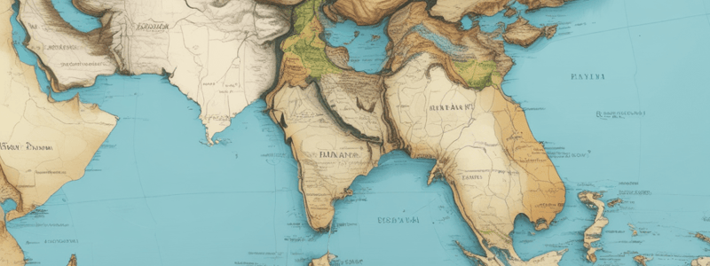
India's Geographic Position
- India is considered a southward extension of the Asian continent.
- The Indian Ocean has facilitated close contact with West Asia, Africa, and Europe.
- India's unique position in relation to the Indian Ocean has enabled maritime trade and contacts with other regions since ancient times.
Impact of the Suez Canal
- The opening of the Suez Canal in 1869 reduced India's distance from Europe.
Island Groups and Coastline
- The Andaman and Nicobar islands are separated from the Indian mainland by the Bay of Bengal.
- Sri Lanka is separated from India by the Palk Strait.
- The Lakshadweep Islands are situated off the coast of Kerala.
- The Maldives is a group of islands situated to the south of the Lakshadweep Islands.
Latitude and Longitude
- The southernmost point of the Indian mainland is around 8°4'N latitude.
- India's east-west extent appears smaller than the north-south extent due to its 30° latitudinal and longitudinal extent.
- 82°30'E is selected as the Standard Meridian of India.
Day and Night Duration
- The duration of day and night as one moves from south to north in India is influenced by latitude.
- Differences between day and night durations differ in Kanniyakumari and Kashmir due to their varying latitudes.
Trade Routes and Maritime Contacts
- The Indian Ocean has played a significant role in connecting India with other regions.
- The Suez Canal significantly impacted Indian Ocean trade routes.
- The Arabian Sea and the Bay of Bengal are divided by the Indian peninsula.
- The east-west extent of India has contributed significantly to the exchange of ideas and commodities since ancient times.
- The Tropic of Cancer passes through eight Indian States.
Historical Aspect
- India's historical interactions with the world are highlighted in the text, emphasizing maritime trade and contacts with other regions.
- Prior to the construction of the Suez Canal, the Cape of Good Hope route was predominantly used for maritime trade between India and Europe.
Studying That Suits You
Use AI to generate personalized quizzes and flashcards to suit your learning preferences.


