Podcast
Questions and Answers
What is the term for a stream or river that flows parallel to the main stream?
What is the term for a stream or river that flows parallel to the main stream?
yazoo stream
What is the result of a stream or river cutting into itself and taking a shorter course?
What is the result of a stream or river cutting into itself and taking a shorter course?
cutoff meander
What is the term for a wetland that has no clear stream or channel?
What is the term for a wetland that has no clear stream or channel?
unchannelled valley bottom wetland
What is a characteristic of channelled valley bottom wetlands?
What is a characteristic of channelled valley bottom wetlands?
What is formed when a cutoff meander fills with sediment and dries up?
What is formed when a cutoff meander fills with sediment and dries up?
What is an indicator that a wetland is unchannelled?
What is an indicator that a wetland is unchannelled?
What is the primary mechanism by which meanders change position over time?
What is the primary mechanism by which meanders change position over time?
What is the term for the erosion of the outer bank of a meandering stream?
What is the term for the erosion of the outer bank of a meandering stream?
What is the term for the depositional surface on the inner edge of a meandering stream?
What is the term for the depositional surface on the inner edge of a meandering stream?
What is the process by which a meandering stream forms an oxbow lake?
What is the process by which a meandering stream forms an oxbow lake?
What is the term for the eventual fate of an oxbow lake in a dry climate?
What is the term for the eventual fate of an oxbow lake in a dry climate?
What is the term for the hills or ridges along each side of a major stream or river?
What is the term for the hills or ridges along each side of a major stream or river?
What is the term for a wetland that occurs on flat or gently sloping land adjacent to and formed by an alluvial river channel?
What is the term for a wetland that occurs on flat or gently sloping land adjacent to and formed by an alluvial river channel?
What is the process by which a stream flows back and forth across its valley floor?
What is the process by which a stream flows back and forth across its valley floor?
What is the term for a type of wetland that is dominated by the colluvial (gravity-driven) movement of water and material downslope?
What is the term for a type of wetland that is dominated by the colluvial (gravity-driven) movement of water and material downslope?
What is the term for a depression wetland with closed or near-closed elevation contours?
What is the term for a depression wetland with closed or near-closed elevation contours?
Study Notes
Hydrogeomorphic Wetland Classification
- There are six different classifications of wetlands in South Africa based on the underlying geology.
Seeps
- Seeps are located on gently to steeply sloping land and are dominated by the colluvial (gravity-driven), unidirectional movement of water and material downslope.
- They are often located on the sideslopes of a valley but do not typically extend onto a valley floor.
- Water inputs are primarily through subsurface flows from an upslope direction.
- Seeps are often associated with diffuse overland flow during and after rainfall events.
- A seep can share a boundary with a distinct river channel and feed into the channel through diffuse surface flow or subsurface flow.
Depressions
- A depression wetland is an inland aquatic ecosystem with closed or near-closed elevation contours.
- This wetland increases in depth from the perimeter to a central area of greatest depth and within which water typically accumulates.
- Dominant water sources are precipitation, groundwater discharge, interflow, and (diffuse or concentrated) overflow.
- Depressions may be flat-bottomed or round-bottomed and may have any combination of inlets and outlets or lack them completely.
- The extent of the wetland goes beyond the body of water which may be present within the deeper parts of the depression.
Wetland Flats
- Wetland flats often appear as irregularly shaped wetland areas which are not linked to a stream.
- They are often level or near-level areas where waterlogging occurs and can be differentiated from depressions by their lack of defined margins.
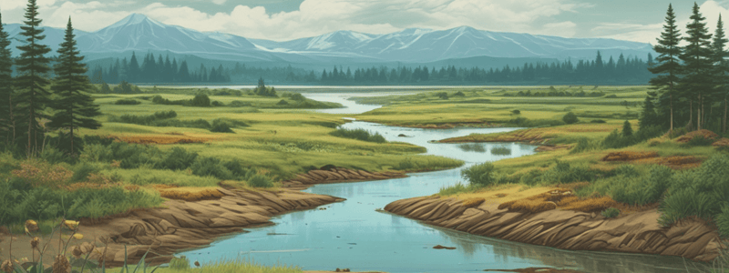
Floodplain Wetlands
- Floodplain wetlands occur on mostly flat or gently sloping land adjacent to and formed by an alluvial river channel.
- These wetlands occur on a plain and are typically characterised by geomorphological features associated with river-derived depositional processes, including point bars, scroll bars, oxbow lakes, and levees.
- Streams located on gentle slopes with low water velocities will flow back and forth, finding the lowest elevation to flow to, resulting in meandering.
- A meandering stream has a single channel that winds snakelike through its valley.
- Over time, a stream will meander back and forth across the flat valley floor, known as the floodplain.
- Lateral erosion shifts the course of the stream over time.
- Meanders change position by eroding sideways and slightly downstream.
- The sideways movement occurs because the maximum velocity of the stream shifts toward the outside of the bend, causing erosion of the outer bank.
- At the same time, the reduced current at the inside of the meander results in the deposition of coarse sediment, especially sand.
- This lateral erosion is concentrated along the outside bank of the meandering stream (primarily due to higher water velocity).
- On the inner bank (slower moving water), soil and silt are being deposited, this is known as fluvial deposition.
- Over time, lateral erosion and fluvial deposition gradually shift the course of the stream back and forth across the floodplain.
- This results in the newer stream course being steeper, generally in a more straight direction with a faster flow.
- Where the bends of two meanders meet, they bypass the curve of the river, creating an oxbow lake which may then be infilled with overwash sediment.
- Erosion along the outer bank eats away at the soil, forming a cutoff meander and a new stream or river channel.
- Eventually, an oxbow lake is created that is separate from the stream or river.
- Oxbow lakes may eventually become swamps, known as oxbow swamps.
- If precipitation is low, these swamps may dry up and form small streams or dry stream beds known as meander scars.
Unchannelled Valley Bottom Wetlands
- Unchannelled valley bottoms will have no clear stream.
- This often requires the wetland assessor to closely examine the area as channels can often be narrow and difficult to find.
- The absence of linear riparian vegetation following a stream is a good indicator that the wetland is unchannelled.
Channelled Valley Bottom Wetlands
- Channelled valley bottom wetlands with visible channels are easily identified as wetlands with a stream or river passing through it.
- The associated wetlands will often appear as wetter, greener vegetation on one or both sides of the stream.
Studying That Suits You
Use AI to generate personalized quizzes and flashcards to suit your learning preferences.
Related Documents
Description
This quiz covers the hydrogeomorphic classification system of wetlands in South Africa, including the six different classifications based on underlying geology. Learn about wetland identification and management in the South African context.