Podcast
Questions and Answers
What is the approximate length of the river mentioned?
What is the approximate length of the river mentioned?
About 700 km
List two tributaries of the river.
List two tributaries of the river.
Amravati, Bharani
Which waterfall does the Kaveri river create?
Which waterfall does the Kaveri river create?
Shivasamudram Falls
What type of lakes are formed by meandering rivers across floodplains?
What type of lakes are formed by meandering rivers across floodplains?
Which is the largest freshwater lake in India?
Which is the largest freshwater lake in India?
Name a project associated with the formation of lakes through damming.
Name a project associated with the formation of lakes through damming.
Identify one smaller river that flows toward the east.
Identify one smaller river that flows toward the east.
What geographical regions does the river basin cover?
What geographical regions does the river basin cover?
What causes the development of ox-bow lakes?
What causes the development of ox-bow lakes?
Name two lakes formed through damming of rivers.
Name two lakes formed through damming of rivers.
Flashcards
Indus River System
Indus River System
The Indus River, originating near Tibet, flows through Ladakh, Baltistan, Zask Gilgit, and joins with several other rivers before emptying into the Arabian Sea east of Karachi.
Ganga River System
Ganga River System
The Ganga River, also known as Bhagirathi in its headwaters, is joined by major tributaries like Yamuna, Kosi, Ghaghara, and Gandak. It receives additional water from peninsular tributaries like Chambal, Betwa, and Son.
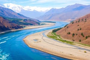
Brahmaputra River System
Brahmaputra River System
The Brahmaputra River, originating in Tibet, takes a U-turn at Namcha Barwa before entering Arunachal Pradesh as Dihang. It is known for its braided channel, riverine islands, and frequent flooding in Assam and Bangladesh.
Oxbow Lakes
Oxbow Lakes
Signup and view all the flashcards
Wular Lake
Wular Lake
Signup and view all the flashcards
Godavari Basin
Godavari Basin
Signup and view all the flashcards
Mahanadi Basin
Mahanadi Basin
Signup and view all the flashcards
Krishna Basin
Krishna Basin
Signup and view all the flashcards
Kaveri Basin
Kaveri Basin
Signup and view all the flashcards
Narmada Basin
Narmada Basin
Signup and view all the flashcards
Study Notes
Drainage Overview
- Himalayan rivers are predominantly perennial.
- Major rivers include Indus and Brahmaputra, originating from the northern mountains.
Indus River System
- Originates near Tibet, close to Lake Mansarowar.
- Enters India in Ladakh, flowing through regions like Baltistan and Zask Gilgit.
- Key tributaries: Shylok, Zhaskar, Nubra, Hunza.
- Joins with Satluj, Ravi, Chenab, and Jhelum before flowing into Pakistan.
- Empties into the Arabian Sea, east of Karachi.
- Basin includes Ladakh, Jammu, Kashmir, Himachal Pradesh, and Punjab.
Ganga River System
- Headwaters known as "Bhagirathi."
- Major tributaries include Yamuna, Kosi, Ghaghara, and Gandak.
- Last three tributaries frequently cause flooding in the Northern plains.
- Additional tributaries from the peninsula: Chambal, Betwa, Son.
Bhagirathi-Hoogly River System
- Flows southwards into deltaic plains, eventually reaching the Bay of Bengal.
- Known downstream as Meghna.
- Merges waters from Brahmaputra and Ganga before entering the Bay of Bengal.
- Creates the Sundarban Delta.
- Ambala is situated on the water divide between Indus and Ganga.
Brahmaputra River System
- Begins in Tibet, east of Mansarowar Lake.
- Takes a 'U' turn at Namcha Barwa before entering Arunachal Pradesh as Dihang.
- Key tributaries include Dibang and Lohit, forming Brahmaputra in Assam.
- Characterized by numerous riverine islands and a braided channel.
- Prone to flooding during the rainy season, affecting Assam and Bangladesh.
- Experiences frequent channel changes and significant sediment deposits that raise the riverbed.
Narmada Basin
- Originates in the Amarakantak hills, Madhya Pradesh.
- Known for picturesque sites like Marble Rocks near Jabalpur and Ohuadur falls.
- Flows westward through a rift valley.
- Basin encompasses parts of Madhya Pradesh and Gujarat.
Tapi Basin
- Rises in the Satpura ranges (Betul district of Madhya Pradesh).
- shorter than Narmada and flows parallel in a rift valley.
- Covers parts of Madhya Pradesh, Gujarat, and Maharashtra.
- Coastal rivers, including Sabarmati, Mahi, Bharapuzha, and Periyar, are relatively short due to a narrow coastal plain.
River Basins of India
Godavari Basin
- Originates from Western Ghats in Maharashtra’s Naik district.
- Largest perennial river, approximately 1500 km long.
- Covers regions including Madhya Pradesh, Odisha, Maharashtra, and Andhra Pradesh.
- Major tributaries: Purna, Wardha, Pranhita, Manjra, Wainganga, Penganga.
- Also known as Dakshin Ganga.
Mahanadi Basin
- Begins in the highlands of Chhattisgarh.
- Approximately 800 km in length.
- Covers Maharashtra, Chhattisgarh, Jharkhand, and Odisha.
Krishna Basin
- Originates from Mahabaleshwar, flows about 1400 km.
- Key tributaries include Tungabadra, Koyana, Ghatprabha, and Musi.
- Covers Maharashtra, Karnataka, and Andhra Pradesh.
Kaveri Basin
- Begins in the Brahmagiri range of Western Ghats.
- Reaches the Bay of Bengal south of Cuddalore in Tamil Nadu.
- Approximately 700 km long with tributaries: Amravati, Bharani, Hemavati, Kobiai.
- Basin spans Tamil Nadu, Karnataka, and Kerala.
- Features the Shivasamudram Falls, the second largest waterfall in India.
Lakes
- Oxbow lakes form when meandering rivers create cut-offs.
- Notable lakes: Chilika, Pulicat, Kolleru; Wular Lake in Jammu & Kashmir is the largest freshwater lake, originating from tectonic activity.
- Other significant lakes include Dal, Nainital, Loktak, and Barapani.
- Damming rivers for hydroelectric power generates lakes, exemplified by Guru Gobind Sagar from the Bhakra Nangal Project.
Studying That Suits You
Use AI to generate personalized quizzes and flashcards to suit your learning preferences.