Podcast
Questions and Answers
What is the primary purpose of conducting an inventory of glaciers?
What is the primary purpose of conducting an inventory of glaciers?
- To measure the thickness of icebergs
- To assess the biodiversity in glacier areas
- To map the locations of various types of flora
- To indicate climate variability and estimate freshwater storage (correct)
What method has been illustrated as effective for measuring variations of surging glaciers?
What method has been illustrated as effective for measuring variations of surging glaciers?
- Ground-based GPS tracking
- Space-borne satellite imagery (correct)
- Aerial photography using drones
- Manual glacier mapping by climbers
What challenge does topographic shadow present in the digital classification of glacier data?
What challenge does topographic shadow present in the digital classification of glacier data?
- Increased cloud cover reduces visibility
- It complicates manual mapping processes only
- It limits automated methods of glacier mapping (correct)
- It affects the spectral properties of the glaciers
How can Digital Elevation Models (DEMs) enhance glacier mapping efforts?
How can Digital Elevation Models (DEMs) enhance glacier mapping efforts?
Which of the following is NOT a characteristic identified from satellite imagery in glacier mapping?
Which of the following is NOT a characteristic identified from satellite imagery in glacier mapping?
What advancement has contributed to increased efficiency in glacier mapping?
What advancement has contributed to increased efficiency in glacier mapping?
Which classification method is commonly used for mapping glacier zones?
Which classification method is commonly used for mapping glacier zones?
What factor does NOT affect the identifiability of glaciological features from SAR backscatter?
What factor does NOT affect the identifiability of glaciological features from SAR backscatter?
What does TSL serve as an indicator of in glacier studies?
What does TSL serve as an indicator of in glacier studies?
How can the end-of-summer snowlines be effectively mapped?
How can the end-of-summer snowlines be effectively mapped?
What is the Equilibrium Line Altitude (ELA) typically characterized by?
What is the Equilibrium Line Altitude (ELA) typically characterized by?
Which method is used to differentiate between accumulation and ablation zones in glaciers?
Which method is used to differentiate between accumulation and ablation zones in glaciers?
What is required to determine the Equilibrium Line Altitude (ELA)?
What is required to determine the Equilibrium Line Altitude (ELA)?
Which imagery allows for identifying the representation of the ice margin of the Greenland ice sheet?
Which imagery allows for identifying the representation of the ice margin of the Greenland ice sheet?
How can glacier margins and their temporal changes be delineated?
How can glacier margins and their temporal changes be delineated?
Which of the following techniques was used to estimate ELA for modern glaciers in central Nepal?
Which of the following techniques was used to estimate ELA for modern glaciers in central Nepal?
What is the primary function designed for the MISR satellite?
What is the primary function designed for the MISR satellite?
What unique feature does the Advanced SAR (ASAR) on the Envisat satellite provide?
What unique feature does the Advanced SAR (ASAR) on the Envisat satellite provide?
What limitation does Radarsat currently have in radar interferometry?
What limitation does Radarsat currently have in radar interferometry?
What is a significant outcome of the continuous collection of remotely sensed data for glaciers?
What is a significant outcome of the continuous collection of remotely sensed data for glaciers?
What aspect do aerial photographs particularly excel in compared to satellite imagery?
What aspect do aerial photographs particularly excel in compared to satellite imagery?
What advantage does satellite data provide concerning glaciers?
What advantage does satellite data provide concerning glaciers?
Which satellite is designed to enhance the continuity of data measurements of the ESA ERS satellites?
Which satellite is designed to enhance the continuity of data measurements of the ESA ERS satellites?
How do medium spatial resolution satellite images limit their applications?
How do medium spatial resolution satellite images limit their applications?
What aspect of glacier research has not been thoroughly explored according to the content?
What aspect of glacier research has not been thoroughly explored according to the content?
According to Allen (1998), which variables are factored to predict glacier morphology?
According to Allen (1998), which variables are factored to predict glacier morphology?
What potential does the integration of remote sensing, GIS, and GPS hold for glaciology?
What potential does the integration of remote sensing, GIS, and GPS hold for glaciology?
What has been exploited to a highly limited degree in glaciology?
What has been exploited to a highly limited degree in glaciology?
What is anticipated with increasing integration of remote sensing and GIS in glaciology?
What is anticipated with increasing integration of remote sensing and GIS in glaciology?
Which of the following best describes the current state of remote sensing of glaciers?
Which of the following best describes the current state of remote sensing of glaciers?
What does the content suggest about future glacier monitoring?
What does the content suggest about future glacier monitoring?
The integration of which technologies is expected to enhance the study of glaciers?
The integration of which technologies is expected to enhance the study of glaciers?
What was the primary focus of Duguay's 1993 study?
What was the primary focus of Duguay's 1993 study?
Which publication discussed the comparison of glacier ice velocities inferred from GPS and satellite images?
Which publication discussed the comparison of glacier ice velocities inferred from GPS and satellite images?
Which glaciers were included in Driedger's 1986 study on ice volumes?
Which glaciers were included in Driedger's 1986 study on ice volumes?
Which method was used by Østrem in 1975 for monitoring glacier mass balance?
Which method was used by Østrem in 1975 for monitoring glacier mass balance?
What was a primary focus of the study by Ormsby and Hall in 1991?
What was a primary focus of the study by Ormsby and Hall in 1991?
What technological method did Gandolfi and colleagues use in their 1997 study?
What technological method did Gandolfi and colleagues use in their 1997 study?
Which technological method was employed by Shi and Dozier in 1993 for measuring snow-covered areas?
Which technological method was employed by Shi and Dozier in 1993 for measuring snow-covered areas?
What was the subject matter of Frezzotti's 1993 research?
What was the subject matter of Frezzotti's 1993 research?
Which publication discusses the fast recession of the Larsen Ice Shelf?
Which publication discusses the fast recession of the Larsen Ice Shelf?
Which study specifically combined DEM parameters with Landsat imagery for mountain glacier characterization?
Which study specifically combined DEM parameters with Landsat imagery for mountain glacier characterization?
Which glaciers were the subjects of aerial laser altimetry in Garvin and Williams's 1993 study?
Which glaciers were the subjects of aerial laser altimetry in Garvin and Williams's 1993 study?
What type of data did Manby use for analyzing Arctic ice-snow fields?
What type of data did Manby use for analyzing Arctic ice-snow fields?
In which year was the study on snow reflectance from Thematic Mapper presented?
In which year was the study on snow reflectance from Thematic Mapper presented?
In what year did Shi et al. study snow mapping in Alpine regions?
In what year did Shi et al. study snow mapping in Alpine regions?
Which study focused on the impacts of seasonal climatic changes on alpine glaciers?
Which study focused on the impacts of seasonal climatic changes on alpine glaciers?
What was the primary finding of Piwowar and LeDrew's 1995 analysis?
What was the primary finding of Piwowar and LeDrew's 1995 analysis?
Flashcards
Glacier Inventory
Glacier Inventory
A process of cataloging glaciers, used to track climate variability and freshwater storage.
Satellite Imagery
Satellite Imagery
Images of Earth taken from satellites, useful for observing glaciers, especially for identification of icepack.
SAR Images
SAR Images
Synthetic Aperture Radar images, helpful for mapping snow cover on glaciers, despite seasonality.
Digital Image Analysis
Digital Image Analysis
Signup and view all the flashcards
Topographic Shadow
Topographic Shadow
Signup and view all the flashcards
DEM (Digital Elevation Model)
DEM (Digital Elevation Model)
Signup and view all the flashcards
Glacier Mapping
Glacier Mapping
Signup and view all the flashcards
Maximum Likelihood Classification
Maximum Likelihood Classification
Signup and view all the flashcards
Equilibrium Line Altitude (ELA)
Equilibrium Line Altitude (ELA)
Signup and view all the flashcards
Terminal Snow Line (TSL)
Terminal Snow Line (TSL)
Signup and view all the flashcards
Glacier Ice/Firn Discoloration
Glacier Ice/Firn Discoloration
Signup and view all the flashcards
Remote Sensing for Glacier Study
Remote Sensing for Glacier Study
Signup and view all the flashcards
Ablation Zone
Ablation Zone
Signup and view all the flashcards
Accumulation Zone
Accumulation Zone
Signup and view all the flashcards
Landsat MSS/TM imagery
Landsat MSS/TM imagery
Signup and view all the flashcards
Glacier Terminus Position
Glacier Terminus Position
Signup and view all the flashcards
Glacier Morphology Prediction
Glacier Morphology Prediction
Signup and view all the flashcards
Remote Sensing of Glaciers
Remote Sensing of Glaciers
Signup and view all the flashcards
GIS and GPS in Glaciology
GIS and GPS in Glaciology
Signup and view all the flashcards
Multi-temporal Images
Multi-temporal Images
Signup and view all the flashcards
Environmental Variables
Environmental Variables
Signup and view all the flashcards
Topographic Variables
Topographic Variables
Signup and view all the flashcards
Glacier Spatial Extent
Glacier Spatial Extent
Signup and view all the flashcards
Glacier Monitoring
Glacier Monitoring
Signup and view all the flashcards
MISR's Limitation in Glaciology
MISR's Limitation in Glaciology
Signup and view all the flashcards
Envisat Satellite Launch
Envisat Satellite Launch
Signup and view all the flashcards
ASAR High Spatial Resolution
ASAR High Spatial Resolution
Signup and view all the flashcards
Radarsat's Variable Resolution
Radarsat's Variable Resolution
Signup and view all the flashcards
Radarsat 2 Improvement
Radarsat 2 Improvement
Signup and view all the flashcards
Remote Sensing Data Continuity
Remote Sensing Data Continuity
Signup and view all the flashcards
Global Glacier Database
Global Glacier Database
Signup and view all the flashcards
Airborne vs. Satellite Imagery for Glaciers
Airborne vs. Satellite Imagery for Glaciers
Signup and view all the flashcards
Snow Reflectance from Landsat Imagery
Snow Reflectance from Landsat Imagery
Signup and view all the flashcards
Glacier Ice Velocity from Remote Sensing
Glacier Ice Velocity from Remote Sensing
Signup and view all the flashcards
Comparing Glacier Velocities
Comparing Glacier Velocities
Signup and view all the flashcards
Glacier Monitoring with GPS & Satellites
Glacier Monitoring with GPS & Satellites
Signup and view all the flashcards
Computer Analysis of Glacier Dynamics
Computer Analysis of Glacier Dynamics
Signup and view all the flashcards
Airborne Laser Altimetry of Glaciers
Airborne Laser Altimetry of Glaciers
Signup and view all the flashcards
Combining DEM with Satellite Imagery
Combining DEM with Satellite Imagery
Signup and view all the flashcards
Landsat MSS/TM Imagery in Glacier Study
Landsat MSS/TM Imagery in Glacier Study
Signup and view all the flashcards
Landsat Digital Examination
Landsat Digital Examination
Signup and view all the flashcards
Spectral Properties of Fog
Spectral Properties of Fog
Signup and view all the flashcards
Single-Polarization SAR
Single-Polarization SAR
Signup and view all the flashcards
Glacier Mass Balance Monitoring
Glacier Mass Balance Monitoring
Signup and view all the flashcards
SPOT Multispectral Data
SPOT Multispectral Data
Signup and view all the flashcards
Hypertemporal Analysis
Hypertemporal Analysis
Signup and view all the flashcards
Seasonal Climatic Forcing
Seasonal Climatic Forcing
Signup and view all the flashcards
Snow Mapping in Alpine Regions
Snow Mapping in Alpine Regions
Signup and view all the flashcards
Study Notes
Applications of Remote Sensing, GIS, and GPS in Glaciology: A Review
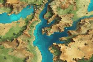
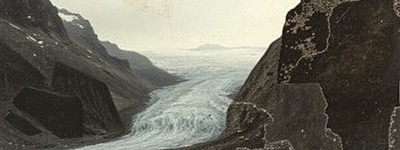
- Remote sensing is an efficient method for gathering glacier data, particularly useful for remote, inaccessible regions.
- GIS and GPS tools enhance the analysis and monitoring of glacier temporal dynamics.
- Many researchers utilize remote sensing, GIS, and GPS for glacier studies.
- Glacier features visible from aerial photos and satellite imagery include extent, snowlines, accumulation/ablation zones, and ice/snow differentiation.
- Digital image processing improves ease and accuracy in mapping these parameters.
- Radar imagery and GPS extend traditional visible/infrared remote sensing to 3D volume estimation and dynamic monitoring.
- GIS enables detection of longitudinal glacial extent variations over time.
- GPS independently determines glacier ice velocity and surface information.
- Integration of non-conventional remote sensors (like SAR interferometry) with GIS and GPS has yet to be fully applied to predict global glacier behavior over longer periods.
- Spectral properties of glacier ice are crucial for differentiation from other surfaces through reflectance or albedo.
- Factors affecting remote sensing of glaciers include spectral, spatial, and temporal resolutions.
- Remote sensing is feasible due to discernible spectral properties of glaciers.
- Atmospheric correction is essential for accurate remote sensing measurements.
- Optical remote sensing includes aerial photography, using VNIR cameras, and satellite imagery (Landsat, SPOT, AVIRIS).
- Microwave remote sensing, including imaging radar (SIR, ERS, Radarsat, SAR) allows data capture through cloud cover.
- Air-borne scanning imagery, like AVIRIS, provides hyperspectral data for detailed spectral analysis.
- Space-borne satellites provide repetitive data for long-term glacier monitoring.
- Glacier features identifiable through remote sensing include frontal termini, snowlines, accumulation/ablation zones.
- Remote sensing enables glacier inventory and mapping, spatial variations, and velocity estimation.
- Glacier motion can be determined by feature tracking, radar interferometry, and multi-temporal imagery co-registration.
Utility of Remote Sensing Materials
- Remote sensing materials useful for glaciology fall into optical and microwave categories.
- Optical materials include aerial photography and satellite imagery.
- Microwave materials include imaging radar like SIR, ERS, Radarsat, and SAR.
- Spectral resolution and spatial resolution characteristics of imagery/sensors are important.
Studying That Suits You
Use AI to generate personalized quizzes and flashcards to suit your learning preferences.
Related Documents
Description
Explore the critical role of remote sensing, GIS, and GPS in glaciology through this review quiz. Learn how these technologies contribute to the analysis and monitoring of glaciers, revealing vital data on ice dynamics and temporal changes. Test your knowledge on the methods used by researchers in the study of glaciers and their features.