Podcast
Questions and Answers
ما هي أكبر دولة في الشرق الأوسط؟
ما هي أكبر دولة في الشرق الأوسط؟
- السعودية
- تركيا
- إيران
- مصر (correct)
أي من الخيارات التالية ليس من المناطق الجغرافية الرئيسية لمصر؟
أي من الخيارات التالية ليس من المناطق الجغرافية الرئيسية لمصر؟
- الواحات
- الجبال الشاهقة (correct)
- الصحراء
- المناطق الساحلية
ما هي المنطقة الأكثر خصوبة في مصر؟
ما هي المنطقة الأكثر خصوبة في مصر؟
- الساحل الشرقي للبحر الأحمر
- واحة سيوة
- الصحراء الغربية
- منطقة دلتا النيل (correct)
ما هي درجات خطوط العرض التي تقع ضمنها مصر؟
ما هي درجات خطوط العرض التي تقع ضمنها مصر؟
أي الخيارات التالية يصف مناخ مصر بشكل صحيح؟
أي الخيارات التالية يصف مناخ مصر بشكل صحيح؟
ما هي المدينة الساحلية الرئيسية في مصر؟
ما هي المدينة الساحلية الرئيسية في مصر؟
ما هي نسبة المساحة التي تغطيها الصحراء في مصر؟
ما هي نسبة المساحة التي تغطيها الصحراء في مصر؟
ما هي الواحات الرئيسية في مصر؟
ما هي الواحات الرئيسية في مصر؟
ما هي المصادر الطبيعية الرئيسية في مصر؟
ما هي المصادر الطبيعية الرئيسية في مصر؟
ما هو المصدر الرئيسي للمياه العذبة في مصر؟
ما هو المصدر الرئيسي للمياه العذبة في مصر؟
ما هي التهديدات الرئيسية للتنوع البيولوجي في مصر؟
ما هي التهديدات الرئيسية للتنوع البيولوجي في مصر؟
ما هي بعض الحيوانات البرية الشائعة في مصر؟
ما هي بعض الحيوانات البرية الشائعة في مصر؟
Flashcards are hidden until you start studying
Study Notes
Geography of Egypt
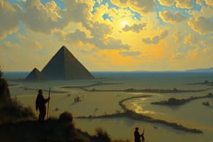
Egypt is the largest country in the Middle East, stretching along the northeastern coast of Africa far into the heart of Asia. It was the southernmost example of the Nile Valley civilizations, which extended northward through the Sinai Peninsula, and southward into Sudan. The Nile River runs along the floor of this valley.
Location
Situated between latitudes 25° and 33° North, and between longitudes 27° and 39° East, Egypt has borders with Libya to the west, Sudan to the south and from the Red Sea to the east, Jordan and Israel to the southeast. Egypt's total area is about 386,660 square miles.
Climate
Egypt enjoys two main climates: tropical desert climate in the eastern part of the country and Mediterranean climate in the western part. The summer months from May to October are hot, while winter lasts from November to April when temperatures drop. Rainfall varies across the country, with most of it concentrated in the northern areas around Alexandria and the Nile Delta.
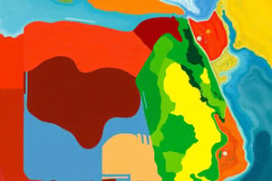
Physical Features
The geographical features of Egypt can be divided into three distinct regions: the coastal region, the oases and the desert.
Coastal Region
Egypt's coastline stretches over 950 miles along the Mediterranean Sea. The coastal region includes parts of the Nile Delta, Alexandria and other cities like Port Said, Damietta, Rosetta, and Marsa Matruh. It's a fertile area with many agricultural sites and green landscapes.
Oases
The oasis regions of Egypt include Bahariya, Farafra, Siwa, Kharga and Dakhla. They are situated in the desert, with limited water and vegetation. Despite their harsh conditions, they have their own unique beauty and attractions.
Desert
The desert region covers about 80% of Egypt's land area. It includes the Sahara Desert, Libyan Desert, and Eastern Desert. The desert is known for its vast sand dunes, rocky mountains, and sparse vegetation.
Natural Resources
Egypt is rich in natural resources, including petroleum, natural gas, iron ore, and phosphates. The country also has significant water resources, with the Nile River supplying about 95% of its water.
Minerals
Egypt's mineral resources include gold, coal, phosphates, various salts, and potash. The country has significant reserves of natural gas and crude oil, with the Western Desert being a major oil-producing area.
Water
The Nile River is the primary source of water for Egypt, providing 95% of its fresh water. The country also has several power stations that depend on the Nile for their water.
Biodiversity
Egypt has a diverse range of wildlife, including various species of birds, mammals, reptiles, and insects. The country's biodiversity is threatened by habitat destruction and over-exploitation of natural resources.
Wildlife
Some of the wildlife found in Egypt include different species of gazelles, oryx, addax, fennec fox, sand cat, desert hedgehog, and a variety of snakes. The country also has a rich avifauna, with over 300 species of birds.
Threats to Biodiversity
Habitat destruction and over-exploitation of natural resources are the main threats to Egypt's biodiversity. The country's rapid urbanization and industrialization have led to the destruction of natural habitats and the loss of biodiversity.
Environmental Challenges
Egypt faces several environmental challenges, including desertification, air pollution, water scarcity, and the loss of agricultural land. These challenges are exacerbated by climate change and population growth.
Desertification
Desertification is a major environmental challenge in Egypt, with the country losing about 2,500 square miles of land each year. This is primarily due to climate change, overgrazing, and deforestation.
Air Pollution
Air pollution is another environmental concern in Egypt, with high levels of particulate matter and nitrogen oxides affecting the health of the population.
Water Scarcity
Water scarcity is a significant challenge in Egypt, with the country experiencing water shortages due to increasing demand and decreasing water resources.
Loss of Agricultural Land
Egypt has lost about 20% of its agricultural land to urbanization and industrialization. This has led to a decline in agricultural production and a rise in food imports.
Geological History
Egypt's geological history dates back to the Paleozoic era, with the country's rocks forming part of the African shield. The country's geology is characterized by several periods of volcanic activity and the formation of various rock types.
Studying That Suits You
Use AI to generate personalized quizzes and flashcards to suit your learning preferences.