Podcast
Questions and Answers
What is the highest peak in Germany?
What is the highest peak in Germany?
Zugspitze
Which river forms a natural border with Austria and passes through the Bavarian Alps?
Which river forms a natural border with Austria and passes through the Bavarian Alps?
Danube River
What are the three major climatic zones in Germany?
What are the three major climatic zones in Germany?
oceanic, continental, subpolar oceanic
What is the predominant geological composition of Germany?
What is the predominant geological composition of Germany?
What is the average annual temperature in Germany?
What is the average annual temperature in Germany?
Which region in Germany experiences heavy snowfall in some years?
Which region in Germany experiences heavy snowfall in some years?
What are some of the most fertile areas for agriculture in Germany?
What are some of the most fertile areas for agriculture in Germany?
Name three of Germany's major cities with a predominantly urban population.
Name three of Germany's major cities with a predominantly urban population.
What type of ecological resource are Germany's forests considered to be?
What type of ecological resource are Germany's forests considered to be?
How many protected areas are there within Germany's borders?
How many protected areas are there within Germany's borders?
Flashcards
Germany's Topography
Germany's Topography
Germany's terrain includes lowlands, forests, mountains, and rivers. The highest peak is Zugspitze.
Germany's Climate
Germany's Climate
Germany has a maritime climate with mild winters and warm summers, divided into oceanic, continental, and subpolar oceanic zones.
Germany's Geological Formations
Germany's Geological Formations
Germany's geology consists mainly of sedimentary rocks, with granite, gneiss, and limestone in some areas.
Average Temperatures in Germany
Average Temperatures in Germany
Signup and view all the flashcards
Germany's Precipitation
Germany's Precipitation
Signup and view all the flashcards
Sunshine in Germany
Sunshine in Germany
Signup and view all the flashcards
Agriculture in Germany
Agriculture in Germany
Signup and view all the flashcards
Forests of Germany
Forests of Germany
Signup and view all the flashcards
Urbanization in Germany
Urbanization in Germany
Signup and view all the flashcards
Conservation in Germany
Conservation in Germany
Signup and view all the flashcards
Study Notes
Germany's Geography: Exploring Physical Features, Climate, and Land Use
Germany, a country brimming with history and culture, boasts a diverse landscape that significantly contributes to its unique charm. In this comprehensive article, we'll delve deeper into the three subtopics of Germany's geography: physical features, climate, and land use.
Physical Features
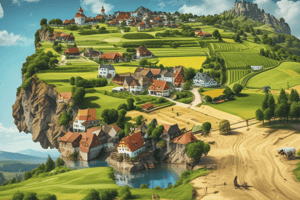
Topography: Germany's terrain is a fascinating blend of lowlands, forests, mountains, and rivers. The highest peak, Zugspitze, stands 2,962 meters tall, while the expansive North German Plain, a flat region stretching across the northern part of the country, dominates the central lowlands. Germany's most prominent river, the Danube River, cuts through the country from west to east, forming a natural border with Austria and passing through the picturesque Bavarian Alps.
Climate: Germany's climate is predominantly maritime, with mild winters and warm summers. The country is divided into three major climatic zones: oceanic in the west, continental in the east, and subpolar oceanic in the highest Alpine regions. The North Atlantic weather system brings cool and wet conditions to the west, while the East European Plain experiences warmer and drier summers. The Alps, as Germany's largest mountain range, have a distinctly colder and snowier climate.
Geological Formations: Germany's geology is primarily composed of sedimentary rocks, with some areas exhibiting granite, gneiss, and limestone. The Harz Mountains, for instance, are home to some of the world's most extensive slate formations. The Saar-Nahe Basin features thick layers of sedimentary rock, while the Black Forest's soils are rich in loess.
Climate
Temperature: Germany experiences an average annual temperature of around 11°C (52°F). The average temperature in January, which is typically the coldest month, is around -2°C (28°F), while July, the warmest month, averages 18°C (64°F).
Precipitation: Germany's annual precipitation varies between regions, ranging from around 600mm (23.6 inches) in the Alpine regions to 800mm (31.5 inches) in the northwest. Snowfall can occur between October and April, with regions like the Black Forest and the Harz Mountains seeing heavy snowfall in some years.
Sunshine: Germany sees an average of around 1,800 hours of sunshine each year, with areas near the coast experiencing more hours of sunshine than inland regions.
Land Use
Agriculture: Germany is a major agricultural producer and exporter, with the Black Forest, the Lower Rhine, and the Mecklenburg Lake District being some of the most fertile areas. The country is known for its high-quality beef, pork, and dairy products, as well as its extensive wine production.
Forests: Germany is home to some of Europe's most extensive forests, with more than 20% of its land area covered by forests. Among the most famous forests are the Black Forest, the Bavarian Forest, and the Harz Mountains. Germany's forests are an essential ecological resource, providing habitats for numerous species and playing a crucial role in climate regulation.
Urbanization: Germany's urban population is concentrated in the country's major cities like Berlin, Munich, and Hamburg. These cities boast a rich history, vibrant culture, and thriving business districts. Germany's population is predominantly urban, with around 75% of the population living in urban areas.
Conservation: Germany is a leader in environmental conservation, with more than 4,000 protected areas within its borders. These protected areas include national parks, nature reserves, and biosphere reserves, and they serve as important habitats for numerous species and preserve unique natural landscapes.
In conclusion, Germany's geography is a fascinating blend of physical features, climate, and land use that contribute to its unique appeal. From the expansive forests and rivers to the diverse agricultural landscapes and thriving cities, Germany offers its citizens and visitors an abundance of natural beauty, culture, and opportunity.
Studying That Suits You
Use AI to generate personalized quizzes and flashcards to suit your learning preferences.