Podcast
Questions and Answers
What is a peneplain and how is formed?
What is a peneplain and how is formed?
A peneplain is an extensive flat region formed when uplift and denudation rates match each other, reducing topography gradually.
Describe the main features of the Youth stage in Davis's geographical cycle.
Describe the main features of the Youth stage in Davis's geographical cycle.
In the Youth stage, features include V-shaped valleys, limited floodplain formation, and the presence of waterfalls and rapids.
What are the main types of superficial mass movements mentioned in the content?
What are the main types of superficial mass movements mentioned in the content?
Mudflow, soil slump, rockfall, and soil creep are among the main types of superficial mass movements.
How does geomorphometry contribute to geomorphology?
How does geomorphometry contribute to geomorphology?
What distinguishing characteristics define the Maturity stage of a landscape?
What distinguishing characteristics define the Maturity stage of a landscape?
What is the role of Geographic Information Systems (GIS) in geomorphology?
What is the role of Geographic Information Systems (GIS) in geomorphology?
Explain the significance of monadnocks in geomorphology.
Explain the significance of monadnocks in geomorphology.
How do concave slopes develop in a landscape?
How do concave slopes develop in a landscape?
What features are characterized under the category of incised streams in the map?
What features are characterized under the category of incised streams in the map?
Describe the relationship between climate and karst landscape development.
Describe the relationship between climate and karst landscape development.
What role does climate play in shaping karst landscapes?
What role does climate play in shaping karst landscapes?
What is a solifluction lobe and where is it typically found?
What is a solifluction lobe and where is it typically found?
Identify and describe a geomorphological feature created during the Maturity stage.
Identify and describe a geomorphological feature created during the Maturity stage.
What processes are involved in the reduction of topography to a peneplain?
What processes are involved in the reduction of topography to a peneplain?
Identify one geomorphological feature that can result from rockfall.
Identify one geomorphological feature that can result from rockfall.
What does the presence of terracettes indicate about a landscape?
What does the presence of terracettes indicate about a landscape?
What are the main surface processes affecting geomorphology on planets?
What are the main surface processes affecting geomorphology on planets?
How does climatic geomorphology relate to landform development?
How does climatic geomorphology relate to landform development?
In the context of planetary geomorphology, what is a morphological map?
In the context of planetary geomorphology, what is a morphological map?
What role does solar energy play in the surface processes of celestial bodies?
What role does solar energy play in the surface processes of celestial bodies?
Define what landform elements are in the context of geomorphology.
Define what landform elements are in the context of geomorphology.
Explain how climate can influence geomorphic processes.
Explain how climate can influence geomorphic processes.
What factors might affect the geomorphological features observed in a specific location?
What factors might affect the geomorphological features observed in a specific location?
What is the significance of the site concept in climatic geomorphology?
What is the significance of the site concept in climatic geomorphology?
Flashcards
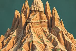
Peneplain
Peneplain
A wide, nearly flat area formed by long-term erosion of a landscape.
Monadnock
Monadnock
A hill or mountain that stands higher than the surrounding, eroded land.
Geomorphic Cycle
Geomorphic Cycle
A theoretical model that describes the stages of landscape formation caused by erosion and uplift.
Youth Stage (Landscape Evolution)
Youth Stage (Landscape Evolution)
Signup and view all the flashcards
Maturity Stage (Landscape Evolution)
Maturity Stage (Landscape Evolution)
Signup and view all the flashcards
Old Age Stage (Landscape Evolution)
Old Age Stage (Landscape Evolution)
Signup and view all the flashcards
Concave Slope
Concave Slope
Signup and view all the flashcards
Straight Slopes
Straight Slopes
Signup and view all the flashcards
Planetary Geomorphology
Planetary Geomorphology
Signup and view all the flashcards
Morphological Mapping
Morphological Mapping
Signup and view all the flashcards
Landform Elements
Landform Elements
Signup and view all the flashcards
Climatic Geomorphology
Climatic Geomorphology
Signup and view all the flashcards
Weathering
Weathering
Signup and view all the flashcards
Aeolian Activity
Aeolian Activity
Signup and view all the flashcards
Fluvial Activity
Fluvial Activity
Signup and view all the flashcards
Glacial Activity
Glacial Activity
Signup and view all the flashcards
Geomorphometry
Geomorphometry
Signup and view all the flashcards
DEM
DEM
Signup and view all the flashcards
DTM
DTM
Signup and view all the flashcards
Systems Approach (Geomorphology)
Systems Approach (Geomorphology)
Signup and view all the flashcards
Hillslope System
Hillslope System
Signup and view all the flashcards
Interfluve
Interfluve
Signup and view all the flashcards
Landform Descriptors
Landform Descriptors
Signup and view all the flashcards
Geomorphometry Contributions
Geomorphometry Contributions
Signup and view all the flashcards
Study Notes
Geomorphology: Landform Evolution and Processes
- Landform Development Stages:
- Straight slopes develop during steady-state uplift/denudation.
- Concave slopes form when uplift rate is less than denudation rate, signifying waning development.
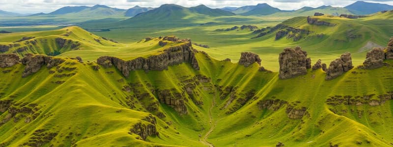
- Landscapes progress through youth, maturity, and old age, eventually reaching a peneplain (extensive flat region). Occasional monadnocks (hills) remain as erosion remnants.
- Geomorphic Cycle (Davis):
- Youth: V-shaped valleys, few streams, limited floodplains, waterfalls, broad divides, some meanders.
- Maturity: Integrated drainage, streams exploiting weaknesses, streams graded, floodplains common, maximum relief.
- Old Age: Mature drainage, floodplains extensive, minimal relief, gentle slopes.
- Geomorphometry:
- Studies land surface form quantitatively.
- Uses remote sensing and GIS.
- Is rooted in Humboldt and Ritter's work.
- Vital for terrain analysis and surface modeling.
- Planetary Geomorphology:
- Studies landforms on planets with solid crusts (e.g., Venus, Mars).
- Processes depend on solar energy, rotation periods, and atmospheric conditions.
- Processes include weathering, aeolian (wind), fluvial (water), glacial, and mass wasting.
- Climatic Geomorphology:
- Recognizes that different climates (tropical, arid, temperate) create distinct landforms.
- While climate influences processes, characteristic landforms are likely influenced by combined tectonic and climate changes.
Geomorphological Systems and Mapping
- Systems Approach:
- Geomorphic systems (e.g., hillslopes) are composed of interacting parts (e.g., rock, organic matter).
- A hillslope system extends from an interfluve to the valley floor.
- Morphological Maps:
- Aims to identify and map landform units.
- Uses aerial photos, field observations, and maps.
- Landform element descriptors include (but aren’t limited to): facets;sites; land elements; terrain components; and facies.
- 'Site' (Linton 1951) is an advancement incorporating descriptions of altitude, extent, slope, curvature, ruggedness, and relation to the water table.
- Digital Elevation Models (DEMs):
- Subset of Digital Terrain Models (DTMs).
- Allow direct computation of topographic elements.
- Mass Movements:
- Includes mudflows, earthflows, peat bursts, soil slumps, rockfalls, scree, solifluction lobes, terracettes, soil creep, and block creep.
Studying That Suits You
Use AI to generate personalized quizzes and flashcards to suit your learning preferences.