Podcast
Questions and Answers
What is a small, low island of coral or sand called?
What is a small, low island of coral or sand called?
cay
What are islands formed by limestone skeletons of animals called?
What are islands formed by limestone skeletons of animals called?
coral islands
What are steady air currents between about 30° north and south latitude and the equator called?
What are steady air currents between about 30° north and south latitude and the equator called?
trade winds
Another name for the Caribbean region is ____.
Another name for the Caribbean region is ____.
How many islands compose the Caribbean and what are they called?
How many islands compose the Caribbean and what are they called?
What is the largest island group in the Caribbean region?
What is the largest island group in the Caribbean region?
Which islands form the Greater Antilles?
Which islands form the Greater Antilles?
How many countries make up the Caribbean region?
How many countries make up the Caribbean region?
What is the name of the largest island in the Caribbean?
What is the name of the largest island in the Caribbean?
What are the two main natural hazards that threaten the islands of the Caribbean?
What are the two main natural hazards that threaten the islands of the Caribbean?
The islands of the Caribbean formed from ____.
The islands of the Caribbean formed from ____.
The climate of most of the Caribbean islands is ____.
The climate of most of the Caribbean islands is ____.
What are the most valuable resources of the Caribbean islands?
What are the most valuable resources of the Caribbean islands?
Flashcards
What is a cay?
What is a cay?
A small, low island formed of coral or sand, also known as a key.
How are coral islands formed?
How are coral islands formed?
These islands are formed by the accumulated limestone skeletons of marine animals.
What are trade winds?
What are trade winds?
Steady air currents located between 30° north and south latitude and the equator, critical for sailing routes.
What is the West Indies?
What is the West Indies?
Signup and view all the flashcards
What are the three main island groups of the Caribbean?
What are the three main island groups of the Caribbean?
Signup and view all the flashcards
What are the Greater Antilles?
What are the Greater Antilles?
Signup and view all the flashcards
What is the largest island in the Greater Antilles?
What is the largest island in the Greater Antilles?
Signup and view all the flashcards
What is the geographic structure of the Lesser Antilles?
What is the geographic structure of the Lesser Antilles?
Signup and view all the flashcards
How are the Lesser Antilles divided?
How are the Lesser Antilles divided?
Signup and view all the flashcards
What are The Bahamas?
What are The Bahamas?
Signup and view all the flashcards
What is the climate of the Caribbean?
What is the climate of the Caribbean?
Signup and view all the flashcards
What are some natural threats to the Caribbean?
What are some natural threats to the Caribbean?
Signup and view all the flashcards
What are the valuable resources of the Caribbean?
What are the valuable resources of the Caribbean?
Signup and view all the flashcards
Study Notes
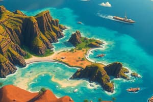
Geography of the Caribbean
- Cay: Refers to a small, low island formed of coral or sand, also known as a key.
- Coral Islands: Formed by the limestone skeletons of marine animals.
- Trade Winds: Steady air currents located between 30° north and south latitude and the equator, critical for sailing routes.
- West Indies: Another name for the Caribbean region, emphasizing historical and geographical significance.
- Composition of Islands: The Caribbean consists of three primary island groups: Greater Antilles, Lesser Antilles, and the Bahamas.
Greater Antilles
- Largest Island Group: Comprises Cuba, Jamaica, Hispaniola (Haiti and Dominican Republic), and Puerto Rico.
- Cuba: The largest island in the group, covering 40,543 sq miles (105,006 sq km).
- Historical Significance: Strategically important due to proximity to the United States; served as key stopovers for maritime trade between Europe and the Americas.
Lesser Antilles
- Archipelago Structure: An arching series of islands separating the Caribbean Sea from the Atlantic Ocean.
- Geographical Division: Split into Windward Islands (southeastern islands affected by trade winds) and Leeward Islands (protected from winds).
- Examples: Windward Islands include Dominica, Martinique, St. Lucia, St. Vincent, and Grenada; Leeward Islands include Antigua, Barbuda, and the Virgin Islands.
The Bahamas
- Geographical Overview: An archipelago of around 700 islands and 200 cays between Florida and Cuba, with only 30 inhabited.
- Tourism Appeal: Noted for stunning beaches and a pleasant climate, making it a popular tourist destination.
Climate and Natural Hazards
- Tropical Climate: Most Caribbean islands experience a tropical climate influenced by trade winds.
- Natural Threats: Hurricanes and volcanic eruptions pose significant risks to the region.
Key Country Details
- Cuba: Largest Caribbean country, located about 100 miles (145 km) south of Florida; characterized by flat plains and mountainous regions; experiences droughts and hurricanes.
- Jamaica: South of Cuba, smaller than Connecticut, predominantly mountainous with rich mineral deposits; vulnerable to seasonal hurricanes.
- Martinique: A mountainous island in the Windward group, noted for scenic beauty but prone to natural hazards like hurricanes and volcanic eruptions.
- Montserrat: Volcanic within the Leeward Islands; characterized by a lack of resources and threats from volcanic activity.
- Bahamas: Features low-lying coral landscapes, suffering frequent hurricane damage.
Valuable Resources of the Caribbean
- Natural Resources: Beaches, climate, and marine waters are the most valuable resources, driving tourism and local economies.
- Environmental Challenges: Frequent hurricanes and tropical storms create challenges for infrastructure and recovery efforts.
Studying That Suits You
Use AI to generate personalized quizzes and flashcards to suit your learning preferences.