Podcast
Questions and Answers
Which river forms part of Serbia's northern border?
Which river forms part of Serbia's northern border?
- Nile
- Danube (correct)
- Amazon
- Mississippi
What is the highest point in Serbia?
What is the highest point in Serbia?
- Mount Titan (correct)
- Mount Everest
- Mount Kilimanjaro
- Mount Fuji
Which of the following is not a bordering country of Serbia?
Which of the following is not a bordering country of Serbia?
- Romania
- Hungary
- Albania
- Spain (correct)
What type of terrain mainly makes up Serbia's landscape?
What type of terrain mainly makes up Serbia's landscape?
Which season in Serbia experiences warm summers with temperatures reaching up to 30°C?
Which season in Serbia experiences warm summers with temperatures reaching up to 30°C?
What is the name of the national park in Serbia known for its unique landscape?
What is the name of the national park in Serbia known for its unique landscape?
What factor has contributed to the varied landscapes of Serbia?
What factor has contributed to the varied landscapes of Serbia?
Which rivers form natural boundaries for Serbia?
Which rivers form natural boundaries for Serbia?
What is the approximate land area of Serbia in square kilometers?
What is the approximate land area of Serbia in square kilometers?
Which industry contributes significantly to employment and exports in Serbia?
Which industry contributes significantly to employment and exports in Serbia?
Which countries share land borders with Serbia?
Which countries share land borders with Serbia?
Who led the First Serbian Uprising against Turkish oppression in 1804?
Who led the First Serbian Uprising against Turkish oppression in 1804?
How does Serbia's climate vary across different regions?
How does Serbia's climate vary across different regions?
Which natural resource does Serbia have a significant amount of?
Which natural resource does Serbia have a significant amount of?
What type of climate can be expected in higher altitudes of Serbia during summer?
What type of climate can be expected in higher altitudes of Serbia during summer?
Which international organization is Serbia NOT a member of?
Which international organization is Serbia NOT a member of?
What is the estimated GDP per capita of Serbia in 2020?
What is the estimated GDP per capita of Serbia in 2020?
Which country does Serbia NOT maintain close relations with?
Which country does Serbia NOT maintain close relations with?
Flashcards are hidden until you start studying
Study Notes
Geography of Serbia
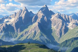
Serbia is a country located in Southeastern Europe, with its capital Belgrade being one of the oldest cities in central and eastern parts of the continent. Bordering seven other countries—Albania, Bulgaria, Croatia, Hungary, Kosovo, North Macedonia, and Romania—it covers an area of approximately 77,498 square miles, which ranks it among the larger European nations. Its terrain mainly consists of rolling hills and plains, particularly in the north and south.
The Danube River forms part of Serbia's northern border and flows through the nation from west to east before emptying into the Black Sea in neighboring Romania. In addition to major rivers such as the Drina, Save, Morava, Timok, Tisza, and Sava, there are also several lakes within the borders of Serbia, including Palic Lake and Vlasinsko Jezero. Mount Titan is the highest point in the country.
Climate-wise, Serbia experiences four distinct seasons, ranging from cold winters with ample snowfall to warm summers where temperatures can reach upwards of 30°C (86°F). Rainfall occurs throughout the year, although precipitation tends to peak during spring months.
In terms of physical features, Serbia boasts numerous mountain ranges like Kopaonik, Zlatibor, Suva Planina, Fruska Gora, Fruška Gora National Park, Gučevo, Vidova Gora, Velika Rudina, Mount Rtanj, Šar Mountains, and Kaimakchalan. These mountains contribute significantly to the unique landscapes found across different regions of the country.
Studying That Suits You
Use AI to generate personalized quizzes and flashcards to suit your learning preferences.