Podcast
Questions and Answers
What climatic condition contributes to the low population density in the Northern Mountains?
What climatic condition contributes to the low population density in the Northern Mountains?
- Severe climate making it inhospitable (correct)
- Abundant rainfall all year round
- Frequent earthquakes and landslides
- High temperatures in summer
Which of the following crops is commonly cultivated in the Northern Mountains?
Which of the following crops is commonly cultivated in the Northern Mountains?
- Rice
- Cotton
- Sugarcane
- Wheat (correct)
What is a primary source of livelihood for residents of the Northern Mountains aside from agriculture?
What is a primary source of livelihood for residents of the Northern Mountains aside from agriculture?
- Fishing
- Mining for gold
- Manufacturing textiles
- Lumbering (correct)
What role do the snow-capped peaks play in the ecosystem of the Northern Mountains?
What role do the snow-capped peaks play in the ecosystem of the Northern Mountains?
Which of the following features is vital for trade connectivity to neighboring countries?
Which of the following features is vital for trade connectivity to neighboring countries?
What type of farming is primarily practiced in the river valleys of the Northern Mountains?
What type of farming is primarily practiced in the river valleys of the Northern Mountains?
Which of the following fruits is NOT typically grown in the Northern Mountains?
Which of the following fruits is NOT typically grown in the Northern Mountains?
How does the climate of the upper Indus plain benefit agricultural practices?
How does the climate of the upper Indus plain benefit agricultural practices?
What is the highest pass in the region mentioned?
What is the highest pass in the region mentioned?
Which rivers provide drainage to the area discussed?
Which rivers provide drainage to the area discussed?
What is a significant climatic characteristic of the region?
What is a significant climatic characteristic of the region?
What happens to water supply in the region during cold weather?
What happens to water supply in the region during cold weather?
What geographical feature describes the average height of the Himalayas?
What geographical feature describes the average height of the Himalayas?
Which sub-range of the Himalayas is known to be the southernmost?
Which sub-range of the Himalayas is known to be the southernmost?
What is the approximate height range of the Lesser Himalayas?
What is the approximate height range of the Lesser Himalayas?
What forced the residents in the region to adopt indoor activities?
What forced the residents in the region to adopt indoor activities?
What is the average height range of the Potwar Plateau?
What is the average height range of the Potwar Plateau?
Which river is NOT part of the drainage system of the Potwar Plateau?
Which river is NOT part of the drainage system of the Potwar Plateau?
What are khaderas in the context of the Potwar Plateau?
What are khaderas in the context of the Potwar Plateau?
Which mineral is NOT commonly found in the Potwar Plateau?
Which mineral is NOT commonly found in the Potwar Plateau?
What defines the southern boundary of the Potwar Plateau?
What defines the southern boundary of the Potwar Plateau?
Which of the following lakes is part of the inland drainage system of the Potwar Plateau?
Which of the following lakes is part of the inland drainage system of the Potwar Plateau?
Which feature is characteristic of the topography of the Potwar Plateau?
Which feature is characteristic of the topography of the Potwar Plateau?
Which of the following mountain ranges is NOT mentioned in relation to the Potwar Plateau?
Which of the following mountain ranges is NOT mentioned in relation to the Potwar Plateau?
Which rivers are classified as minor tributaries of the Indus River?
Which rivers are classified as minor tributaries of the Indus River?
What distinguishes the left-hand tributaries from the right-hand tributaries of the Indus?
What distinguishes the left-hand tributaries from the right-hand tributaries of the Indus?
What geographical features can be found in the Upper Indus Plain?
What geographical features can be found in the Upper Indus Plain?
Where does the River Indus flow before reaching the Arabian Sea?
Where does the River Indus flow before reaching the Arabian Sea?
What is the average width of the Indus River near Sukkur?
What is the average width of the Indus River near Sukkur?
How is the Upper Indus Plain primarily characterized?
How is the Upper Indus Plain primarily characterized?
What types of agricultural advantages does the Upper Indus Plain provide?
What types of agricultural advantages does the Upper Indus Plain provide?
What is the significance of the confluence at Mithankot?
What is the significance of the confluence at Mithankot?
Which mountain range is located to the extreme north of the Balochistan Plateau?
Which mountain range is located to the extreme north of the Balochistan Plateau?
What is a major occupation in the Balochistan Plateau region?
What is a major occupation in the Balochistan Plateau region?
Which of the following rivers is part of the drainage system in the Balochistan Plateau?
Which of the following rivers is part of the drainage system in the Balochistan Plateau?
What climatic condition is mentioned as being ideal for agriculture in Balochistan?
What climatic condition is mentioned as being ideal for agriculture in Balochistan?
Which coastal area is known for its narrow beach and rock cliffs?
Which coastal area is known for its narrow beach and rock cliffs?
How does farming occur in the Balochistan Plateau?
How does farming occur in the Balochistan Plateau?
Which of the following options best describes the population density in Balochistan?
Which of the following options best describes the population density in Balochistan?
What characterizes the inland drainage system of the Balochistan Plateau?
What characterizes the inland drainage system of the Balochistan Plateau?
What primarily distinguishes the Kachhi-Sibi Plain from other plains mentioned?
What primarily distinguishes the Kachhi-Sibi Plain from other plains mentioned?
Which geographic feature is characteristic of the Lower Indus Plain?
Which geographic feature is characteristic of the Lower Indus Plain?
What is a significant function of the River Indus as it flows through the Lower Indus Plain?
What is a significant function of the River Indus as it flows through the Lower Indus Plain?
What is a cuesta in geological terms?
What is a cuesta in geological terms?
Which area is best known for cotton cultivation?
Which area is best known for cotton cultivation?
What geographical area does the Ghaggar channel way border?
What geographical area does the Ghaggar channel way border?
What occurs when the River Indus approaches the Arabian Sea?
What occurs when the River Indus approaches the Arabian Sea?
Which of the following best describes the Indus/Tidal Delta?
Which of the following best describes the Indus/Tidal Delta?
Flashcards
Karakoram Mountain Range
Karakoram Mountain Range
The Karakoram mountain range features deep valleys, sharp cliffs, and high passes like the Karakoram Pass, the highest pass in the world.
Karakoram Highway (KKH)
Karakoram Highway (KKH)
The Karakoram Highway, also known as the Silk Route, is a significant road linking Pakistan and China through the Karakoram mountain range.
Glaciers in the Karakoram
Glaciers in the Karakoram
The Siachin, Hispar, Baifo, Baltoro, and Batura are large masses of ice found in the higher valleys of the Karakoram range.
Climate of the Karakoram
Climate of the Karakoram
Signup and view all the flashcards
Impact of Climate on Karakoram Lifestyle
Impact of Climate on Karakoram Lifestyle
Signup and view all the flashcards
The Himalayas
The Himalayas
Signup and view all the flashcards
The Siwaliks
The Siwaliks
Signup and view all the flashcards
The Lesser Himalayas
The Lesser Himalayas
Signup and view all the flashcards
Transhumance
Transhumance
Signup and view all the flashcards
Northern Mountains of Pakistan
Northern Mountains of Pakistan
Signup and view all the flashcards
Protection from Cold Winds
Protection from Cold Winds
Signup and view all the flashcards
Irrigation from the Mountains
Irrigation from the Mountains
Signup and view all the flashcards
Natural Resources of the Mountains
Natural Resources of the Mountains
Signup and view all the flashcards
Karakoram Highway
Karakoram Highway
Signup and view all the flashcards
Natural Border
Natural Border
Signup and view all the flashcards
Agriculture in the Mountains
Agriculture in the Mountains
Signup and view all the flashcards
What is the Balochistan Plateau?
What is the Balochistan Plateau?
Signup and view all the flashcards
List some key mountain ranges of the Balochistan Plateau.
List some key mountain ranges of the Balochistan Plateau.
Signup and view all the flashcards
Describe the coastal areas of the Balochistan Plateau.
Describe the coastal areas of the Balochistan Plateau.
Signup and view all the flashcards
What is the main occupation of the people living on the Balochistan Plateau?
What is the main occupation of the people living on the Balochistan Plateau?
Signup and view all the flashcards
How is farming practiced in the Balochistan Plateau?
How is farming practiced in the Balochistan Plateau?
Signup and view all the flashcards
Name some key rivers and lakes within the drainage system of the Balochistan Plateau.
Name some key rivers and lakes within the drainage system of the Balochistan Plateau.
Signup and view all the flashcards
Explain the concept of inland drainage in the Balochistan Plateau.
Explain the concept of inland drainage in the Balochistan Plateau.
Signup and view all the flashcards
Name some key lakes that make up the inland drainage system of the Balochistan Plateau.
Name some key lakes that make up the inland drainage system of the Balochistan Plateau.
Signup and view all the flashcards
Plateau
Plateau
Signup and view all the flashcards
Potwar Plateau Location
Potwar Plateau Location
Signup and view all the flashcards
Potwar Plateau Altitude
Potwar Plateau Altitude
Signup and view all the flashcards
Potwar Plateau Topography
Potwar Plateau Topography
Signup and view all the flashcards
Lakes on Potwar Plateau
Lakes on Potwar Plateau
Signup and view all the flashcards
Drainage System of Potwar Plateau
Drainage System of Potwar Plateau
Signup and view all the flashcards
Mountain Ranges of Potwar Plateau
Mountain Ranges of Potwar Plateau
Signup and view all the flashcards
Salt Ranges Location
Salt Ranges Location
Signup and view all the flashcards
What is a tributary?
What is a tributary?
Signup and view all the flashcards
Compare the size of Indus River's eastern and western tributaries.
Compare the size of Indus River's eastern and western tributaries.
Signup and view all the flashcards
Name the major rivers that flow into the Indus River from the east.
Name the major rivers that flow into the Indus River from the east.
Signup and view all the flashcards
What is the Upper Indus Plain?
What is the Upper Indus Plain?
Signup and view all the flashcards
Describe the geographical characteristics of the Upper Indus Plain.
Describe the geographical characteristics of the Upper Indus Plain.
Signup and view all the flashcards
Explain the river system in the Upper Indus Plain.
Explain the river system in the Upper Indus Plain.
Signup and view all the flashcards
What are some landforms found in the Upper Indus Plain due to river activity?
What are some landforms found in the Upper Indus Plain due to river activity?
Signup and view all the flashcards
Why is the Upper Indus Plain suitable for agriculture and industry?
Why is the Upper Indus Plain suitable for agriculture and industry?
Signup and view all the flashcards
Lower Indus Plain
Lower Indus Plain
Signup and view all the flashcards
Cuesta
Cuesta
Signup and view all the flashcards
Delta
Delta
Signup and view all the flashcards
Deposition in Lower Indus Plain
Deposition in Lower Indus Plain
Signup and view all the flashcards
Meanders, Oxbow Lakes, Braided Channels and Levees
Meanders, Oxbow Lakes, Braided Channels and Levees
Signup and view all the flashcards
Kacchi-Sibi Plain
Kacchi-Sibi Plain
Signup and view all the flashcards
Ideal for Industries and Agriculture
Ideal for Industries and Agriculture
Signup and view all the flashcards
Importance of Cuestas
Importance of Cuestas
Signup and view all the flashcards
Study Notes
Pakistan Geography - O Level
- Pakistan Geography is a combination of two words: Geo (land/earth) and Graphy (description).
- It describes the land/earth.
- Pakistan is situated between 24° to 37° North latitudes and 61° to 76.5° East longitudes, covering an area of 796,096 square kilometers.
- It extends over 1600 km from north to south and 885 km from east to west.
- Pakistan borders Afghanistan (2252 km), China (585 km), Iran, and India, as well as the Arabian Sea to the south.
- Pakistan has five provinces: Balochistan, Punjab, Sindh, Khyber Pakhtunkhwa, and Gilgit-Baltistan.
- East Pakistan was separated in 1971 to become Bangladesh.
Topography
- Topography studies and describes the surface features of land, both natural and artificial.
- Pakistan's topography is divided into seven major zones: Northern Mountains, Western Mountains, Balochistan Plateau, Potwar Plateau and Salt Ranges, Indus Plain, and Desert Areas.
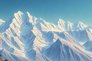
Northern Mountains
- Composed of three mountain ranges: Karakoram, Himalayas, and Hindu Kush
- Karakoram Range: Located north of the Indus River, stretching from Hunza to Shyok; average height 6000 m; K2 is its second highest peak.
- Himalayas: South of the Karakoram; average height is 4000 m; includes Siwaliks, Lesser Himalayas, and Central Himalayas; famous for Mount Everest in its Central Himalayas section
- Hindu Kush: West of the Karakoram and Himalayas, spans Pakistan's northwestern border with Afghanistan.
- Important passes and valleys (e.g. Khyber Pass, Shandur Pass, Hunza Valley).
- Climate characterized by extreme cold, heavy snow, and large daily temperature fluctuations.
- Activities like transhumance (seasonal migration) and terraced farming are common.
Western Mountains
- Lie in the western part of Pakistan, stretching along the border with Afghanistan, and are lower than the Northern mountains.
- Include Waziristan hills, Sulaiman ranges, Kirthar ranges.
- They are generally lower in altitude than the Northern Ranges.
- Mountain ranges are important passes (e.g., Khyber Pass, Bolan Pass)
- More typical desert-like regions in the west.
Balochistan Plateau
- Located west of the Sulaiman and Kirthar ranges, spanning 347,190 square kilometers; an upland region with slopes.
- Its altitude varies from 600–3000 meters.
- The area is dry; vegetation is limited, rivers are temporary or intermittent.
- Rich in natural resources, such as gas, minerals (like oil, gold, and copper).
Potwar Plateau and Salt Ranges
- Located in the Northwest of the Punjab Province, covering roughly 18,000 km².
- Has an average height of 300-600 m.
- Its northern boundary is marked by the Kala Chitta and Margalla hills, and the south by the salt ranges.
- The area is composed of ravines, ridges, and gullies.
- Contains rocks, like limestone, and resources like salt, gypsum, and coal
Indus Plain
- A vast flatland formed by the Indus River and its tributaries, extending to the Arabian Sea.
- It's formed by alluvium (sediments deposited by the river).
- Divisible into Upper and Lower sections
- Upper Section: between Attock to Mithankot and wider.
- Lower section: between Mithankot to Thatta and narrower
- Ideal for agriculture.
Desert Areas
- Pakistan has three major desert regions: the Thar, Cholistan, and Kharan deserts.
- Hot summers and mild winters are characteristic with very low rainfall.
- Suitable for the rearing of animals like goats and sheep.
- Limited agricultural activities.
Other Features
- Avalanches, landslides, are common in mountainous areas.
- Rivers are significant for water resources, with the Indus River being the largest.
- Climate varies greatly, moving from a high altitude cold climate to a semi-arid/arid climate in the southwest
Studying That Suits You
Use AI to generate personalized quizzes and flashcards to suit your learning preferences.