Podcast
Questions and Answers
What is the 2nd highest point in the Philippines?
What is the 2nd highest point in the Philippines?
- Rocky Mountains
- Mt. Pulag (correct)
- Transantarctic Mountains
- Kitanglad Mountain Range
Which mountain range is considered the tallest in North America?
Which mountain range is considered the tallest in North America?
- Transantarctic Mountains
- Rocky Mountains (correct)
- Appalachian Mountains
- Andes Mountains
What type of mountains are formed by the collision of two or more tectonic plates?
What type of mountains are formed by the collision of two or more tectonic plates?
- Fault-block Mountains
- Residual Mountains
- Fold Mountains (correct)
- Volcanic Mountains
Which mountain range divides Antarctica into two parts?
Which mountain range divides Antarctica into two parts?
Which range is found near the equator?
Which range is found near the equator?
What is a common characteristic of the Rocky Mountains?
What is a common characteristic of the Rocky Mountains?
What contributes to the Sahara Desert's dryness?
What contributes to the Sahara Desert's dryness?
What is true about volcanoes?
What is true about volcanoes?
What type of tectonic plates form the Earth's continents?
What type of tectonic plates form the Earth's continents?
Which layer of the Earth is primarily responsible for the movement of tectonic plates?
Which layer of the Earth is primarily responsible for the movement of tectonic plates?
What is a common misconception about oceanic plates?
What is a common misconception about oceanic plates?
What leads to the formation of volcanoes?
What leads to the formation of volcanoes?
What type of volcanic hazard involves the dangerous flow of molten rock?
What type of volcanic hazard involves the dangerous flow of molten rock?
How thick can the Earth's crust vary?
How thick can the Earth's crust vary?
Which of the following is NOT a volcanic hazard?
Which of the following is NOT a volcanic hazard?
What is the composition of the Earth's crust?
What is the composition of the Earth's crust?
What is the primary role of the core in relation to the Earth's mantle?
What is the primary role of the core in relation to the Earth's mantle?
What is primarily responsible for the continuous reshaping and formation of Earth's crust?
What is primarily responsible for the continuous reshaping and formation of Earth's crust?
Which layers make up the Earth's core?
Which layers make up the Earth's core?
Which type of lava is characterized as light-colored and high in silica?
Which type of lava is characterized as light-colored and high in silica?
What term describes the area in the Earth's mantle where magma rises to create volcanic activity?
What term describes the area in the Earth's mantle where magma rises to create volcanic activity?
Which scientist proposed the concept of Seafloor Spreading in the early 1960s?
Which scientist proposed the concept of Seafloor Spreading in the early 1960s?
What is the primary characteristic of basaltic lava?
What is the primary characteristic of basaltic lava?
What is a consequence of tectonic plate movements at fault lines?
What is a consequence of tectonic plate movements at fault lines?
Which volcanic feature is typically formed by basaltic lava?
Which volcanic feature is typically formed by basaltic lava?
What geological feature is often formed at divergent boundaries?
What geological feature is often formed at divergent boundaries?
What is the temperature range typically associated with rhyolitic lava?
What is the temperature range typically associated with rhyolitic lava?
What geological process is responsible for the creation of the Philippine archipelago?
What geological process is responsible for the creation of the Philippine archipelago?
What process describes the rising, spreading, and sinking of materials in the mantle?
What process describes the rising, spreading, and sinking of materials in the mantle?
What term refers to the boundary between tectonic plates?
What term refers to the boundary between tectonic plates?
Which of the following is a characteristic of rhyolite rock?
Which of the following is a characteristic of rhyolite rock?
What is the significance of sonar in the study of seafloor spreading?
What is the significance of sonar in the study of seafloor spreading?
What was the name given to the single landmass that existed around 250 million years ago?
What was the name given to the single landmass that existed around 250 million years ago?
What did the discovery of rocks of the same type and age across the Atlantic Ocean indicate?
What did the discovery of rocks of the same type and age across the Atlantic Ocean indicate?
Who is known as the Father of Plate Tectonics?
Who is known as the Father of Plate Tectonics?
What significant geological process is referred to as orogeny?
What significant geological process is referred to as orogeny?
During which period did Laurasia and Gondwanaland form?
During which period did Laurasia and Gondwanaland form?
Which regions were included in Laurasia?
Which regions were included in Laurasia?
What hints at a single mountain range between the Appalachian and Caledonian mountains?
What hints at a single mountain range between the Appalachian and Caledonian mountains?
What term describes the large ocean that existed during the time of Pangea?
What term describes the large ocean that existed during the time of Pangea?
Flashcards are hidden until you start studying
Study Notes
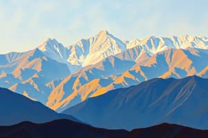
Mountains and Mountain Ranges
- Atlas Mountains: 2nd highest point in the Philippines, located in Africa at 2938m (9639 ft).
- Kitanglad Mountain Range: Home to Mt. Pulag, the 3rd highest point in the Philippines at 2922m (9587 ft).
- Rocky Mountains: Tallest mountain range in North America, located west of North America, characterized by steep slopes and sharp edges.
- Andes Mountains: Found in South America, features confined summit and significant local relief; part of a major mountain range system.
- Transantarctic Mountains: Divide Antarctica into two parts; important geographical feature of the continent.
- Great Dividing Range: Stretching across Australia, it influences weather patterns and contributes to moisture scarcity in the area.
Geological Structures
- Volcanoes: Formed as a vent in the crust, associated with tectonic activity; include both active and inactive types.
- Types of Mountain Formation:
- Fold Mountains: Created by the collision of tectonic plates, leading to crust buckling.
- Evidence includes orogeny (uplifting and folding) and geological features related to plate tectonics.
- Tectonic Plates: Comprised of oceanic (thinner, denser) and continental (thicker, less dense) crust types. Movement of these plates leads to geological formations.
Earth Layers
- Earth’s Crust: Varies in thickness from 5 km to 50 km, includes both oceanic and continental crust.
- Mantle: Divided into upper and lower sections; the upper mantle works with the lithosphere to facilitate tectonic plate movement.
- Core: Composed of inner (solid) and outer (semi-liquid) core; generates heat needed to maintain mantle mobility.
Volcanic Activity
- Volcanoes can occur at tectonic plate boundaries or hotspots where magma rises to the surface.
- Common volcanic hazards: Lava flows, ash falls, volcanic bombs, and lahars.
- Types of Lava:
- Rhyolitic Lava: Light-colored, high in silica, explosive in nature, ranges from 800°C to 1000°C.
- Basaltic Lava: Dark-colored, low in silica, less explosive, forms shield volcanoes.
Seafloor Spreading
- Concept of seafloor spreading involves divergence of tectonic plates, leading to new crust formation.
- Evidence includes matching geological formations across continents, supporting the theory of plate tectonics and prior landmass formations.
- Harry Hess' theory in the early 1960s proposed seafloor spreading as a key mechanism for plate tectonics.
Historical Geography
- Pangea: Supercontinent existed around 250 million years ago, contained almost all landmasses; supports the theory of continental drift.
- Laurasia and Gondwanaland: Formed during the Early Jurassic Period, showcasing the continuous split of continents over geological time.
- Fossils and geological matching reveal shared origins of mountain ranges across separate landmasses, such as the Appalachian and Caledonian Mountains.
Tectonic Activity and Earthquake Generation
- Most earthquakes occur along fault lines where tectonic plates interact.
- Pacific Ocean region known as the "Ring of Fire" is a hotbed for earthquakes and volcanic activity.
- Movement in the Earth’s layers driven by convection currents contributes to both mountain building and volcanic activity.
Studying That Suits You
Use AI to generate personalized quizzes and flashcards to suit your learning preferences.