Podcast
Questions and Answers
Which continent is known to have no permanent residents?
Which continent is known to have no permanent residents?
- Africa
- Australia
- Antarctica (correct)
- North America
Which is the only continent that is also classified as a country?
Which is the only continent that is also classified as a country?
- South America
- Australia (correct)
- Asia
- North America
What is the largest continent by area?
What is the largest continent by area?
- Africa
- Europe
- South America
- Asia (correct)
Which continent is noted as the most populated?
Which continent is noted as the most populated?
What is a characteristic feature of Antarctica?
What is a characteristic feature of Antarctica?
What is the first step in plotting latitude and longitude?
What is the first step in plotting latitude and longitude?
Which direction do you move when plotting latitude?
Which direction do you move when plotting latitude?
In plotting longitude, which direction do you typically go?
In plotting longitude, which direction do you typically go?
What need to be done before practicing coordinates?
What need to be done before practicing coordinates?
What is the recommended way to improve clarity while plotting latitude and longitude?
What is the recommended way to improve clarity while plotting latitude and longitude?
Which ocean is the largest in the world?
Which ocean is the largest in the world?
What is another name for the Northern Ocean?
What is another name for the Northern Ocean?
Which ocean is known as the newest ocean?
Which ocean is known as the newest ocean?
Which ocean ranks second in size after the Pacific Ocean?
Which ocean ranks second in size after the Pacific Ocean?
Which ocean is located to the south of Africa?
Which ocean is located to the south of Africa?
Which continent is colored red on the world map?
Which continent is colored red on the world map?
What color represents South America on the map?
What color represents South America on the map?
Which continent is associated with the color light blue?
Which continent is associated with the color light blue?
Identify the continent that is represented in orange.
Identify the continent that is represented in orange.
Which continent is colored green?
Which continent is colored green?
What is the main disadvantage of globes compared to maps?
What is the main disadvantage of globes compared to maps?
Which type of map projection is most accurate near the equator?
Which type of map projection is most accurate near the equator?
What is a benefit of maps compared to globes?
What is a benefit of maps compared to globes?
What does the term 'distortion' refer to in the context of maps?
What does the term 'distortion' refer to in the context of maps?
What is a characteristic of conical map projections?
What is a characteristic of conical map projections?
What is a primary feature of choropleth maps?
What is a primary feature of choropleth maps?
What do physical maps primarily depict?
What do physical maps primarily depict?
What are lines of latitude known as due to their behavior of not intersecting each other?
What are lines of latitude known as due to their behavior of not intersecting each other?
What do isoline maps typically represent?
What do isoline maps typically represent?
At which degrees is the Prime Meridian located?
At which degrees is the Prime Meridian located?
In point symbols maps, what does a larger symbol indicate?
In point symbols maps, what does a larger symbol indicate?
Which of the following is an example of a cartogram map?
Which of the following is an example of a cartogram map?
How do political maps differ from physical maps?
How do political maps differ from physical maps?
Flow-line maps are particularly useful for illustrating which of the following?
Flow-line maps are particularly useful for illustrating which of the following?
What is a defining feature of dot symbol maps?
What is a defining feature of dot symbol maps?
Which geographic line is known to divide the Earth into northern and southern hemispheres?
Which geographic line is known to divide the Earth into northern and southern hemispheres?
What is the maximum degree measurement for latitude?
What is the maximum degree measurement for latitude?
Which type of map is characterized by showing a specific theme or idea?
Which type of map is characterized by showing a specific theme or idea?
How is latitude measured?
How is latitude measured?
In which context would a cartogram map be most effective?
In which context would a cartogram map be most effective?
What might the colors on a political map indicate?
What might the colors on a political map indicate?
How do point symbols differ from isoline maps?
How do point symbols differ from isoline maps?
How are lines of longitude measured?
How are lines of longitude measured?
Which of the following statements is true about isoline maps and dot symbol maps?
Which of the following statements is true about isoline maps and dot symbol maps?
What does the coordinate 35° 0' 26.64" N represent?
What does the coordinate 35° 0' 26.64" N represent?
Which characteristic is common among thematic maps?
Which characteristic is common among thematic maps?
What crucial information does a choropleth map provide through its use of color and shading?
What crucial information does a choropleth map provide through its use of color and shading?
What distinguishes lines of longitude from lines of latitude?
What distinguishes lines of longitude from lines of latitude?
Which of the following statements accurately describes the role of latitude and longitude?
Which of the following statements accurately describes the role of latitude and longitude?
What is the Prime Meridian's degree measurement?
What is the Prime Meridian's degree measurement?
Flashcards are hidden until you start studying
Study Notes
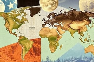
Seven Continents
- Asia is the largest and most populated continent.
- Africa follows in size and population.
- North America, South America, Antarctica (no permanent residents), Europe, and Australia come next in descending order of size.
- Australia is unique as it is both a country and a continent.
- Continents are often organized from largest to smallest size.
Steps to Plotting Latitude/Longitude
- Begin by identifying the center of the grid at coordinates (0,0), where the equator and prime meridian intersect.
- Latitude coordinates are marked by counting north or south from zero.
- Longitude coordinates are determined by moving east or west along the same latitude line.
- Prepare the plotting sheet by tracing significant lines, labeling them, and marking every tenth line.
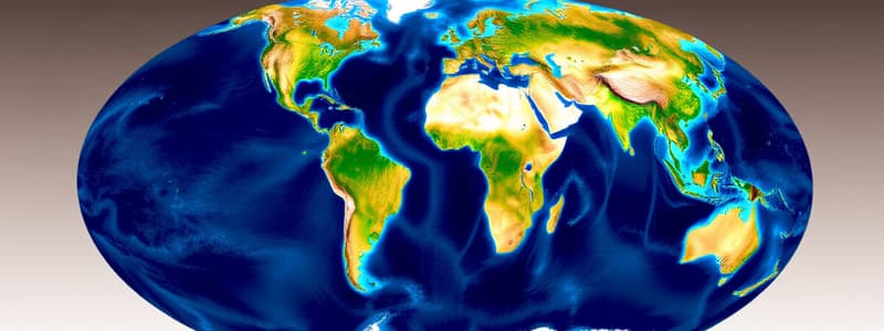
Five Oceans
- Oceans ranked from largest to smallest: Pacific, Atlantic, Indian, Southern (also known as Antarctic), and Northern (also known as Arctic).
- Each ocean is distinctly labeled on maps for easy identification.
Maps vs. Globes
- Globes provide a 3D representation of Earth, being the most accurate but less transportable and detailed than maps.
- Maps are flat (2D) and transportable, capable of depicting more detail but subject to distortions, including size and shape.
Types of Map Projections
- Cylindrical Projections (e.g., Mercator) misrepresent areas as they approach the poles while being accurate near the equator.
- Planar Projections show poles well but distort areas away from them.
- Conical Projections accurately present area and are used for wide expanses or thematic mapping, like population density.
Isoline Maps
- Display lines that connect points of equal value, such as temperature or elevation, often used in topographic maps.
Point Symbols (Proportional Symbols)
- Utilize varied symbol sizes to indicate the occurrence level of a variable; larger dots signal greater amounts.
Dot Symbols Map (Thematic Map)
- 1 dot represents a specified quantity of the variable depicted on the map.
Latitude and Longitude Overview
- Latitude runs horizontally, measured north and south from the equator (0° to 90°).
- Longitude runs vertically, measured east and west from the Prime Meridian (0° to 180°).
Describing Latitude and Longitude
- Latitude is indicated as North/South, ranging from the equator at 0° to the poles at 90°.
- Longitude is indicated as East/West, extending from the Prime Meridian at 0° to the International Date Line at 180°.
Types of Maps
- Physical Maps highlight natural features like rivers and mountains.
- Political Maps show governmental boundaries such as states and countries.
- Thematic Maps focus on a specific theme or idea, offering various detailed representations.
Additional Map Types
- Choropleth Maps use colors and shading to illustrate different variables with specific data.
- Cartogram Maps distort size to display variable differences, e.g., population distribution.
- Flow-Line Maps depict the movement of entities or phenomena, highlighting patterns and statistics related to various movements.
Studying That Suits You
Use AI to generate personalized quizzes and flashcards to suit your learning preferences.