Podcast
Questions and Answers
What are the geographic coordinates of New York City?
What are the geographic coordinates of New York City?
40.7, -74.0
The heavy red line in Figure SM1.2 is a primary reference point for measuring what?
The heavy red line in Figure SM1.2 is a primary reference point for measuring what?
latitude
What is the name of the heavy red line shown in Figure SM1.2?
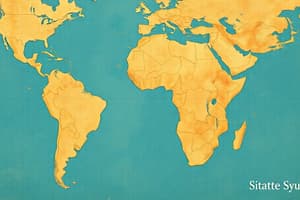
What is the name of the heavy red line shown in Figure SM1.2?
the Equator
What is the angular degree of the heavy red line in Figure SM1.2?
What is the angular degree of the heavy red line in Figure SM1.2?
The heavy red line in Figure SM1.3 is a primary reference point for measuring what?
The heavy red line in Figure SM1.3 is a primary reference point for measuring what?
What is another name for the heavy red line shown in Figure SM1.3?
What is another name for the heavy red line shown in Figure SM1.3?
What is the angular degree of the heavy red line in Figure SM1.3?
What is the angular degree of the heavy red line in Figure SM1.3?
What type of map data are used in Figure SM1.4?
What type of map data are used in Figure SM1.4?
What is the approximate distance in miles between Los Angeles and London as measured in Figure SM1.5?
What is the approximate distance in miles between Los Angeles and London as measured in Figure SM1.5?
What is the approximate distance in kilometers between Tokyo and Lisbon as measured in Figure SM1.5?
What is the approximate distance in kilometers between Tokyo and Lisbon as measured in Figure SM1.5?
Which statement explains why the measured routes between Tokyo and Lisbon curve north?
Which statement explains why the measured routes between Tokyo and Lisbon curve north?
Which layer shows a remote sensing dataset in Figure SM1.6?
Which layer shows a remote sensing dataset in Figure SM1.6?
What do the largest dots on the map in Figure SM1.6 represent?
What do the largest dots on the map in Figure SM1.6 represent?
In what region of the world do most of the circles occur in Figure SM1.6?
In what region of the world do most of the circles occur in Figure SM1.6?
Which region was most affected by the Tohoku tsunami in Figure SM1.6?
Which region was most affected by the Tohoku tsunami in Figure SM1.6?
Which city was most affected by tsunami waves as indicated in Figure SM1.6?
Which city was most affected by tsunami waves as indicated in Figure SM1.6?
Flashcards
What are the geographic coordinates of New York City?
What are the geographic coordinates of New York City?
The latitude of New York City is 40.7 degrees north and the longitude is 74.0 degrees west.
What does the heavy red line in Figure SM1.2 represent?
What does the heavy red line in Figure SM1.2 represent?
The heavy red line in Figure SM1.2 represents the Equator, which is the primary reference point for measuring latitude.
What is the name of the heavy red line shown in Figure SM1.2?
What is the name of the heavy red line shown in Figure SM1.2?
The heavy red line in Figure SM1.2 is called the Equator.
What is the angular degree of the heavy red line in Figure SM1.2?
What is the angular degree of the heavy red line in Figure SM1.2?
Signup and view all the flashcards
What does the heavy red line in Figure SM1.3 represent?
What does the heavy red line in Figure SM1.3 represent?
Signup and view all the flashcards
What is another name for the heavy red line shown in Figure SM1.3?
What is another name for the heavy red line shown in Figure SM1.3?
Signup and view all the flashcards
What is the angular degree of the heavy red line in Figure SM1.3?
What is the angular degree of the heavy red line in Figure SM1.3?
Signup and view all the flashcards
What type of map data are used in Figure SM1.4?
What type of map data are used in Figure SM1.4?
Signup and view all the flashcards
What is the approximate distance in miles between Los Angeles and London as measured in Figure SM1.5?
What is the approximate distance in miles between Los Angeles and London as measured in Figure SM1.5?
Signup and view all the flashcards
What is the approximate distance in kilometers between Tokyo and Lisbon as measured in Figure SM1.5?
What is the approximate distance in kilometers between Tokyo and Lisbon as measured in Figure SM1.5?
Signup and view all the flashcards
Which statement explains why the measured routes between Tokyo and Lisbon curve north?
Which statement explains why the measured routes between Tokyo and Lisbon curve north?
Signup and view all the flashcards
Which layer shows a remote sensing dataset in Figure SM1.6?
Which layer shows a remote sensing dataset in Figure SM1.6?
Signup and view all the flashcards
What do the largest dots on the map in Figure SM1.6 represent?
What do the largest dots on the map in Figure SM1.6 represent?
Signup and view all the flashcards
In what region of the world do most of the circles occur in Figure SM1.6?
In what region of the world do most of the circles occur in Figure SM1.6?
Signup and view all the flashcards
Which region was most affected by the Tohoku tsunami in Figure SM1.6?
Which region was most affected by the Tohoku tsunami in Figure SM1.6?
Signup and view all the flashcards
Which city was most affected by tsunami waves as indicated in Figure SM1.6?
Which city was most affected by tsunami waves as indicated in Figure SM1.6?
Signup and view all the flashcards
Study Notes
Geographic Coordinates and Reference Lines
- New York City's geographic coordinates: 40.7° N latitude, -74.0° W longitude.
- The heavy red line in geographic maps serves as a primary reference for measuring latitude, known as the Equator.
- The Equator is situated at an angular degree of 0°.
Longitude Reference
- The heavy red line for measuring longitude is called the Prime Meridian.
- The Prime Meridian also has an angular degree of 0°.
Map Data and Assessments
- Satellite imagery is the type of map data utilized in geographic figures.
- Estimated distance between Los Angeles, California, and London, England, is approximately 5,400 miles.
- Estimated distance between Tokyo, Japan, and Lisbon, Portugal, is about 11,000 kilometers.
Distortion in Mapping
- Flat world maps distort the representation of spherical globes, causing measured routes to appear curved, particularly noted in routes from Tokyo to Lisbon.
Remote Sensing and City Populations
- The "Recent Weather Radar Imagery" layer shows remote sensing datasets.
- The largest dots on city population maps represent cities with over 14 million inhabitants, predominantly found in southeastern Asia.
Tsunami Impact
- The Tohoku tsunami waves were highest in Hawaii, indicating significant impact in that region.
- Data showing the most affected city by tsunami waves includes Tohoku, Japan, based on the relevant tsunami data layer.
Studying That Suits You
Use AI to generate personalized quizzes and flashcards to suit your learning preferences.