Podcast
Questions and Answers
What process causes a waterfall to retreat upstream, leaving a gorge behind?
What process causes a waterfall to retreat upstream, leaving a gorge behind?
- Meandering
- Infiltration
- Erosion (correct)
- Deposition
Where is the new land created, in a meandering river?
Where is the new land created, in a meandering river?
- The river source
- The outside of the bend
- The straightest part of the river
- The inside of the bend (correct)
What is the term for a smaller river that flows into a larger river?
What is the term for a smaller river that flows into a larger river?
- Watershed
- Confluence
- Mouth
- Tributary (correct)
Which of the following best describes the immediate next step in the water cycle, after condensation occurs?
Which of the following best describes the immediate next step in the water cycle, after condensation occurs?
Which term describes the area of land that is drained by a river and its tributaries?
Which term describes the area of land that is drained by a river and its tributaries?
How does deforestation primarily contribute to increased river discharge?
How does deforestation primarily contribute to increased river discharge?
Which of the following best describes the effect of urbanization on surface runoff?
Which of the following best describes the effect of urbanization on surface runoff?
What is the primary way that agriculture, specifically ploughed land, contributes to increased river discharge?
What is the primary way that agriculture, specifically ploughed land, contributes to increased river discharge?
How does steep relief (shape of the land) contribute to increased river discharge?
How does steep relief (shape of the land) contribute to increased river discharge?
What is the effect of prolonged rainfall on river discharge and soil saturation?
What is the effect of prolonged rainfall on river discharge and soil saturation?
How do permeable rocks influence surface runoff and water collection?
How do permeable rocks influence surface runoff and water collection?
What is the main way a floodplain is formed through the deposition of alluvium?
What is the main way a floodplain is formed through the deposition of alluvium?
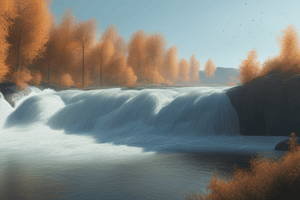
What process primarily erodes the soft rock beneath hard rock in the formation of a waterfall?
What process primarily erodes the soft rock beneath hard rock in the formation of a waterfall?
Flashcards
Meander
Meander
A bend or loop in the course of a river.
Watershed
Watershed
The area of high ground forming the edge of a river basin.
Confluence
Confluence
The point where two rivers meet.
Drainage Basin
Drainage Basin
Signup and view all the flashcards
Source
Source
Signup and view all the flashcards
Deforestation
Deforestation
Signup and view all the flashcards
Urbanisation
Urbanisation
Signup and view all the flashcards
Agriculture
Agriculture
Signup and view all the flashcards
Relief
Relief
Signup and view all the flashcards
Precipitation
Precipitation
Signup and view all the flashcards
Geology
Geology
Signup and view all the flashcards
Floodplain
Floodplain
Signup and view all the flashcards
Formation of a Waterfall
Formation of a Waterfall
Signup and view all the flashcards
Study Notes
Factors Affecting River Discharge and Flooding
-
Deforestation: Removal of trees reduces water absorption by roots, increasing surface runoff and river discharge, potentially leading to flooding.
-
Urbanisation: Increased impermeable surfaces (tarmac, concrete) result in more rapid surface runoff, faster flow into rivers, and a greater flood risk.
-
Agriculture (Farming): Arable farming (crop growing) practices with ploughing create furrows that increase water velocity and river discharge, contributing to flooding.
-
Relief (Land Shape): Steep slopes lead to faster surface runoff, higher river discharge, and increased flood risk.
-
Precipitation: Rainfall, snowmelt, and other forms of precipitation directly increase river discharge and water table levels; prolonged rainfall can saturate soils and contribute to flooding.
-
Geology: Permeable rocks allow water to soak into the ground, reducing surface runoff. Impermeable rocks lead to more surface runoff and increase flood risk.
River Features and Processes
-
Floodplain: A wide, flat area on either side of a river, characteristically lower river course, formed by deposition during floods. Floodplains are composed of alluvium (sediments).
-
Floodplain Formation: Formed by deposition of sediment during floods or lateral erosion by meandering rivers that erode valley sides.
-
Waterfall Formation: Forms where hard rock overlies soft rock; hydraulic action and abrasion erode soft rock, undercutting the hard rock that collapses into a plunge pool, with ongoing erosion moving the waterfall upstream.
-
Meander Formation: A bend or loop in a river; deposit building on the inside of the bend, erosion and loss on the outside of the bend.
-
Watershed: The land area that feeds water into a particular river system. A river begins at a source, flows to a confluence (where two rivers meet), and ends at a mouth (where it meets the sea). Tributaries are smaller rivers or streams that join a larger river.
The Hydrologic Cycle
-
Solar Energy Drives the Cycle: Sun heats Earth's surface, leading to evaporation from water bodies and vegetation.
-
Evaporation, Condensation, Precipitation: Warm air rises (with water vapor), vapor turns to liquid water droplets during condensation, producing clouds. Heavy clouds result in precipitation (rain, snow, sleet, hail).
-
Water Distribution Post Precipitation: Precipitation that reaches the land can run directly into rivers/oceans, be absorbed by soil and vegetation (infiltration), evaporate from leaves, or become overland flow back to rivers/oceans.
Studying That Suits You
Use AI to generate personalized quizzes and flashcards to suit your learning preferences.