Podcast
Questions and Answers
Which of the following scenarios best illustrates a transform plate boundary?
Which of the following scenarios best illustrates a transform plate boundary?
- The subduction of the Nazca plate beneath the South American plate, forming the Andes Mountains.
- The formation of the Himalayan mountains due to the collision of two continental plates.
- The creation of the Mid-Atlantic Ridge where new crust is being formed.
- The occurrence of frequent earthquakes along the San Andreas Fault in California. (correct)
A scientist discovers identical fossilized plants on the coasts of South America and Africa. Which concept does this discovery support?
A scientist discovers identical fossilized plants on the coasts of South America and Africa. Which concept does this discovery support?
- The existence of Pangea. (correct)
- The theory of the expanding Earth.
- The concept of uniformitarianism.
- The principle of superposition.
What is the primary difference between weather and climate?
What is the primary difference between weather and climate?
- Weather describes the day-to-day atmospheric conditions, while climate is the long-term average. (correct)
- Weather refers to atmospheric conditions in the past, while climate describes current conditions.
- Weather is a long-term average of atmospheric conditions, while climate is a day-to-day state.
- Weather only includes temperature, while climate includes temperature, humidity, and precipitation.
How does latitude primarily influence climate?
How does latitude primarily influence climate?
Which of the following is a primary characteristic of plains as a landform region?
Which of the following is a primary characteristic of plains as a landform region?
What is the fundamental difference between mechanical and chemical weathering?
What is the fundamental difference between mechanical and chemical weathering?
Which layer of the Earth is semi-fluid and allows the tectonic plates to move?
Which layer of the Earth is semi-fluid and allows the tectonic plates to move?
What distinguishes oceanic crust from continental crust?
What distinguishes oceanic crust from continental crust?
Which of the following natural hazards is categorized as a meteorological hazard?
Which of the following natural hazards is categorized as a meteorological hazard?
What geographic thinking concept involves understanding how different locations relate to each other?
What geographic thinking concept involves understanding how different locations relate to each other?
Flashcards
Lithosphere
Lithosphere
The solid outermost layer of the Earth, including the crust and upper mantle.
Asthenosphere
Asthenosphere
A semi-fluid layer beneath the lithosphere that allows tectonic plates to move.
Oceanic Crust
Oceanic Crust
Thinner and denser type of crust primarily made of basalt.
Continental Crust
Continental Crust
Signup and view all the flashcards
Convergent Boundary
Convergent Boundary
Signup and view all the flashcards
Divergent Boundary
Divergent Boundary
Signup and view all the flashcards
Transform Boundary
Transform Boundary
Signup and view all the flashcards
Weathering
Weathering
Signup and view all the flashcards
Erosion
Erosion
Signup and view all the flashcards
Weather
Weather
Signup and view all the flashcards
Study Notes
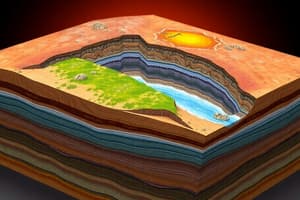
- Earth's structure consists of multiple layers, each with distinct properties and compositions
Earth’s Layers
- Lithosphere: The Earth's solid, outermost layer includes the crust and upper mantle
- Asthenosphere: A semi-fluid layer underneath the lithosphere enables the movement of tectonic plates
- Crust: Earth's thin, outermost layer is divided into oceanic and continental types
Crust Types
- Oceanic Crust: Denser and thinner, primarily composed of basalt
- Continental Crust: Less dense and thicker, mainly composed of granite
Pangea and Plate Tectonics
- Pangea's existence is supported by fossil evidence, similar rock formations across continents, and historical climate data
- Plate boundaries are classified into convergent, divergent, and transform types
Plate Boundary Types
- Convergent Boundary: Plates collide, leading to mountain formation or subduction
- Divergent Boundary: Plates separate, resulting in new crust formation
- Transform Boundary: Plates slide past each other, causing earthquakes
Weathering
- The process of breaking down rocks into smaller pieces
- Mechanical Weathering: Physical breakdown occurs (e.g., freeze-thaw)
- Chemical Weathering: Changes in the chemical composition occur (e.g., rusting)
Erosion
- Erosion involves the transportation of weathered materials by wind, water, or ice
Interior Layers of the Earth
- Mantle: A thick, semi-solid layer of slowly flowing rock
- Outer Core: A liquid layer composed of molten iron and nickel
- Inner Core: A solid, dense center, also composed of iron and nickel
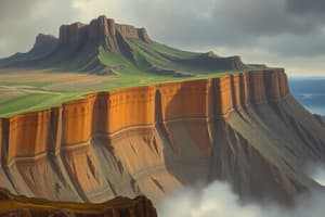
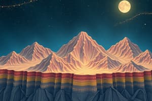
Landform Regions
- Plains: Flat, fertile lands are ideal for agriculture
- Plateaus: Elevated flat lands often feature steep sides
- Mountains: Elevated landforms with rugged terrain
- Hills: Lower and more rounded than mountains
Weather vs. Climate
- Weather: Day-to-day changes in atmospheric conditions, including temperature, humidity, and precipitation
- Climate: Long-term patterns and averages of weather in a region are considered
LOWERN Factors (Climate Influences)
- Latitude: Affects temperature based on proximity to the equator
- Ocean Currents: Influence coastal climates with warm or cold currents
- Wind and Air Masses: Affect temperature and weather patterns
- Elevation: Higher elevations experience cooler temperatures
- Relief: Physical geography influences climate
- Natural Vegetation: Plant life can indicate and affect climate
Natural Hazard Categories
- Hazards are grouped into geological, meteorological, biological, and technological categories
- Geological Hazards: Earthquakes, volcanoes, and tsunamis
- Meteorological Hazards: Hurricanes, tornadoes, and floods
- Biological Hazards: Diseases and pest infestations
- Technological Hazards: Industrial accidents and chemical spills
Geographic Thinking Concepts
- Spatial Organization: Understanding the relationships and connections between different places
- Scale: Level of detail in maps, ranging from local to global
- Environment and Society: The interaction between human activities and the environment
- Place and Region: Defining characteristics of locations and their relationships with one another
Studying That Suits You
Use AI to generate personalized quizzes and flashcards to suit your learning preferences.