Podcast
Questions and Answers
The mantle is almost entirely composed of gaseous substances.
The mantle is almost entirely composed of gaseous substances.
False (B)
The Gutenberg discontinuity marks the boundary between the mantle and the outer core.
The Gutenberg discontinuity marks the boundary between the mantle and the outer core.
True (A)
Convection currents in the mantle are due to Earth's temperature difference and radioactive decay.
Convection currents in the mantle are due to Earth's temperature difference and radioactive decay.
True (A)
Seismic wave velocity remains constant regardless of the medium it passes through in Earth's interior.
Seismic wave velocity remains constant regardless of the medium it passes through in Earth's interior.
Mid-ocean ridges can provide information about mantle composition through the deposition of mantle material.
Mid-ocean ridges can provide information about mantle composition through the deposition of mantle material.
The asthenosphere is a completely solid portion of the upper mantle.
The asthenosphere is a completely solid portion of the upper mantle.
Convection currents are responsible for causing sea breezes on Earth.
Convection currents are responsible for causing sea breezes on Earth.
Obduction can lead to the uplifting of mantle material and its deposition at the Earth's surface.
Obduction can lead to the uplifting of mantle material and its deposition at the Earth's surface.
Index fossils can be used to determine the numerical age of sedimentary rock layers.
Index fossils can be used to determine the numerical age of sedimentary rock layers.
The principle of superposition states that the youngest layer in an undisturbed sequence of rocks is at the base.
The principle of superposition states that the youngest layer in an undisturbed sequence of rocks is at the base.
Contour lines on a topographic map can cross each other.
Contour lines on a topographic map can cross each other.
Alfred Wegener used fossil similarities as evidence for the theory of continental drift.
Alfred Wegener used fossil similarities as evidence for the theory of continental drift.
Tectonic plates consist of both the Earth's crust and upper mantle.
Tectonic plates consist of both the Earth's crust and upper mantle.
The Mid-Atlantic Ridge is a boundary between several tectonic plates.
The Mid-Atlantic Ridge is a boundary between several tectonic plates.
The theory of continental drift was immediately accepted when proposed by Alfred Wegener.
The theory of continental drift was immediately accepted when proposed by Alfred Wegener.
Flashcards
Mantle
Mantle
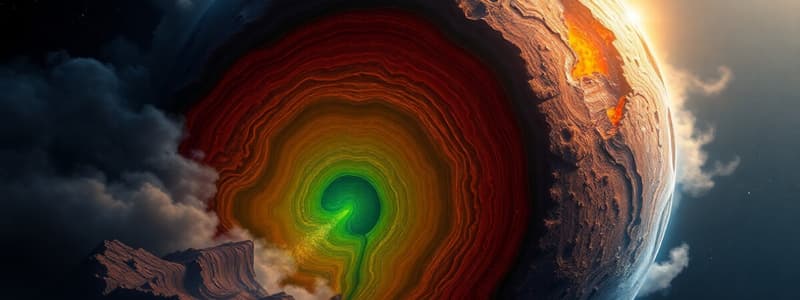
The largest portion of Earth's interior, situated between the crust and the outer core.
Mohorovicic discontinuity
Mohorovicic discontinuity
The boundary between the Earth's crust and the mantle.
Gutenberg discontinuity
Gutenberg discontinuity
The boundary between the mantle and Earth's outer core.
Conduction
Conduction
Signup and view all the flashcards
Radiation
Radiation
Signup and view all the flashcards
Convection
Convection
Signup and view all the flashcards
Asthenosphere
Asthenosphere
Signup and view all the flashcards
Plate tectonics
Plate tectonics
Signup and view all the flashcards
What are fossils?
What are fossils?
Signup and view all the flashcards
What are index fossils?
What are index fossils?
Signup and view all the flashcards
What is the principle of superposition?
What is the principle of superposition?
Signup and view all the flashcards
What is the principle of fossil succession?
What is the principle of fossil succession?
Signup and view all the flashcards
What does a topographic map show?
What does a topographic map show?
Signup and view all the flashcards
What is the theory of continental drift?
What is the theory of continental drift?
Signup and view all the flashcards
What are tectonic plates?
What are tectonic plates?
Signup and view all the flashcards
Study Notes
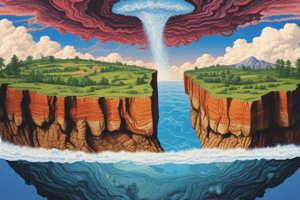
Earth's Mantle
- The mantle is Earth's largest layer, extending from the Mohorovicic discontinuity (35 km) to the Gutenberg discontinuity (2980 km).
- It's almost entirely solid rock, but behaves like a viscous liquid over geological timescales due to convection currents.
- Convection currents are driven by Earth's geothermal gradient (leftover heat from formation, radioactive decay).
- Mantle material rises, reaching the asthenosphere (ductile upper mantle).
- As it moves near the lithosphere, it spreads, decompresses, and some melts.
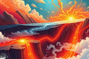
- Melted material can form volcanoes at mid-ocean ridges, revealing mantle composition (mostly peridotite).
- Convection can also uplift mantle rock to the surface (obduction).
- Seismic waves' velocity change based on the material they pass through, helping geophysicists understand conditions within the earth.
Convection Currents
- Convection is a method of heat transfer in fluids (liquids or gases).
- Uneven heating creates density differences that drive currents.
- Heated fluid expands, becomes less dense, and rises.
- Cooler, denser fluid sinks to replace it.
- Examples include sea breezes (land vs. ocean) and a campfire.
- Heat transfer from the fire is also radiant.
Index Fossils and Relative Dating
- Fossils are the remains or traces of ancient organisms.
- Some fossils can't determine rock age or correlation to other layers; index fossils can.
- Index fossils are organisms that lived for a short time, are common, wide-spread, and easily identified.
- Examples include ammonites, trilobites, and graptolites.
- Relative dating determines the order of geological events without numerical dates.
- The principle of fossil succession states specific fossils exist in a limited time frame.
- Combined with the principle of superposition, it helps narrow down the age of rock layers.
- Superposition dictates that older layers are lower in an undisturbed rock sequence.
Topographic Maps
- Topographic maps show elevation using contour lines.
- Contour lines connect points of equal elevation.
- Index contours have elevations marked.
- Contour interval shows elevation change between lines (constant).
- Contour lines don't cross and form circles around hills.
- Hachures indicate depressions.
- Understanding topographic maps is fundamental to geologic maps, which also show rock type and age.
- Geologic maps use colors, and a key to interpret rock type.
Continental Drift
- Alfred Wegener proposed continental drift, suggesting continents have moved.
- Evidence included fitting continental shapes, similar fossils, and landforms.
- Harry Hess later proved the theory after noticing mid-ocean ridges and the seafloor spreading.
Tectonic Plates
- Earth's lithosphere is broken into 7 major plates (and 8 minor).
- Plates are named after continents/oceans above.
- Plates (largest to smallest): Pacific, North American, Eurasian, African, Antarctic, Indo-Australian, South American), and others.
- Plate movement (towards, away, or past each other) causes geological features – mountains, valleys, plateaus – also due to heat transfer from the core..
- A mid-ocean ridge is a ridge in the Atlantic Ocean.
Studying That Suits You
Use AI to generate personalized quizzes and flashcards to suit your learning preferences.