Podcast
Play an AI-generated podcast conversation about this lesson
Download our mobile app to listen on the go
Get App
Questions and Answers
Who created Map 1?
Who created Map 1?
- A British explorer
- A French cartographer
- An Indian scholar
- Al-Idrisi (correct)
What year was Map 2 created?
What year was Map 2 created?
1720s
In Al-Idrisi's map, Sri Lanka is depicted at the bottom.
In Al-Idrisi's map, Sri Lanka is depicted at the bottom.
False (B)
Place-names on Al-Idrisi's map are marked in __________.
Place-names on Al-Idrisi's map are marked in __________.
Signup and view all the answers
Match the following maps with the correct descriptions:
Match the following maps with the correct descriptions:
Signup and view all the answers
Flashcards are hidden until you start studying
Study Notes
Comparison of Historical Maps
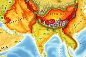
- Map 1, created in 1154 CE, is attributed to the Arab geographer Al-Idrisi.
- This map features a detail of the Indian subcontinent from a larger world map.
- In Al-Idrisi's representation, geographical orientation differs significantly from contemporary maps, with south India depicted where north India is typically found.
- Sri Lanka is positioned at the top of the map, contrary to modern cartographic conventions.
- Place-names on Al-Idrisi's map are written in Arabic, reflecting the cultural context of the time.
Map 2 Characteristics
- Map 2 was produced in the 1720s by a French cartographer, showcasing European cartographic advancements.
- It presents a different perspective of the same region compared to Al-Idrisi's map, highlighting shifts in geographical knowledge over several centuries.
- The contrast between the two maps illustrates the evolution of cartography from medieval Islamic spheres of knowledge to early modern European interpretations.
Studying That Suits You
Use AI to generate personalized quizzes and flashcards to suit your learning preferences.