Podcast
Questions and Answers
What is the main purpose of a thematic map?
What is the main purpose of a thematic map?
- To show relief features such as mountains and valleys
- To show political boundaries and territories
- To preserve shapes and angles of the Earth's surface
- To display specific data such as climate, population, or economy (correct)
What is the effect of increasing latitude on temperature?
What is the effect of increasing latitude on temperature?
- Temperature remains constant
- Temperature increases
- Temperature fluctuates randomly
- Temperature decreases (correct)
What is an example of a non-renewable natural resource?
What is an example of a non-renewable natural resource?
- Fossil fuels (correct)
- Fish
- Freshwater
- Solar energy
What is a significant challenge facing Kibera?
What is a significant challenge facing Kibera?
What is the main advantage of the Mercator projection?
What is the main advantage of the Mercator projection?
What is the definition of climate?
What is the definition of climate?
What is an initiative to improve Kibera?
What is an initiative to improve Kibera?
What is the scale of a map?
What is the scale of a map?
What is a significant contribution of the Sumerians to modern society?
What is a significant contribution of the Sumerians to modern society?
Which ancient civilization is credited with the development of the first alphabetical writing system?
Which ancient civilization is credited with the development of the first alphabetical writing system?
What was a major consequence of the Fall of the Roman Empire?
What was a major consequence of the Fall of the Roman Empire?
What was the main significance of the Edict of Milan?
What was the main significance of the Edict of Milan?
What was a characteristic of the social hierarchy of feudalism?
What was a characteristic of the social hierarchy of feudalism?
What was a significant impact of the Black Death on European society?
What was a significant impact of the Black Death on European society?
What was a characteristic of the High Middle Ages?
What was a characteristic of the High Middle Ages?
Which ancient Greek city-state was known for its emphasis on philosophy?
Which ancient Greek city-state was known for its emphasis on philosophy?
What was a significant achievement of the ancient Romans?
What was a significant achievement of the ancient Romans?
What was a major consequence of the Persian Wars for ancient Greece?
What was a major consequence of the Persian Wars for ancient Greece?
Flashcards are hidden until you start studying
Study Notes
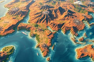
Cartography
- Definition: The study and practice of creating maps to represent the Earth's surface
- Types of maps:
- Topographic maps: Show relief features, such as mountains and valleys
- Political maps: Show boundaries and territories of countries and states
- Thematic maps: Show specific data, such as climate, population, or economy
- Map projections:
- Mercator projection: Preserves shapes and angles, but distorts size and distance
- Gall-Peters projection: Preserves size and distance, but distorts shape and angle
- Scale: The ratio of the distance on the map to the corresponding distance on the Earth's surface
- Symbols and legends: Used to represent different features and provide context on the map
Climate
- Definition: The long-term atmospheric conditions in a particular region
- Factors influencing climate:
- Latitude: Temperature decreases with increasing latitude
- Altitude: Temperature decreases with increasing altitude
- Ocean currents: Warm or cool the surrounding air
- Land use: Deforestation and urbanization affect local climate
- Climate zones:
- Tropical: High temperatures and high humidity near the equator
- Temperate: Moderate temperatures and rainfall in mid-latitudes
- Polar: Cold temperatures and low humidity at the poles
- Climate change: The long-term warming of the planet due to human activities and natural factors
Natural Resources
- Definition: Materials or substances that occur naturally and are valuable for human use
- Types of natural resources:
- Renewable resources: Can be replenished over time, such as solar energy and fish
- Non-renewable resources: Cannot be replenished, such as fossil fuels and minerals
- Examples of natural resources:
- Water: Freshwater and saltwater sources
- Land: Arable land, forests, and minerals
- Energy: Fossil fuels, solar, wind, and geothermal energy
- Importance of natural resources:
- Supports human life and economy
- Can be a source of conflict and cooperation between nations
Kibera
- Definition: A large urban slum in Nairobi, Kenya
- Characteristics:
- High population density: Over 250,000 people per square kilometer
- Poverty: Low-income residents with limited access to basic services
- Unplanned settlement: Informal housing and lack of infrastructure
- Challenges facing Kibera:
- Limited access to clean water and sanitation
- Inadequate healthcare and education facilities
- High crime rates and insecurity
- Initiatives to improve Kibera:
- Slum upgrading projects: Improving housing and infrastructure
- Community-based organizations: Providing social services and advocacy
- Government initiatives: Improving security and providing basic services
Cartography
- Cartography is the study and practice of creating maps to represent the Earth's surface.
- Topographic maps show relief features, such as mountains and valleys.
- Political maps show boundaries and territories of countries and states.
- Thematic maps show specific data, such as climate, population, or economy.
- The Mercator projection preserves shapes and angles, but distorts size and distance.
- The Gall-Peters projection preserves size and distance, but distorts shape and angle.
- Map scale is the ratio of the distance on the map to the corresponding distance on the Earth's surface.
- Symbols and legends are used to represent different features and provide context on the map.
Climate
- Climate is the long-term atmospheric conditions in a particular region.
- Latitude affects climate, with temperature decreasing with increasing latitude.
- Altitude affects climate, with temperature decreasing with increasing altitude.
- Ocean currents warm or cool the surrounding air, affecting climate.
- Land use, such as deforestation and urbanization, affects local climate.
- Tropical climate zones have high temperatures and high humidity near the equator.
- Temperate climate zones have moderate temperatures and rainfall in mid-latitudes.
- Polar climate zones have cold temperatures and low humidity at the poles.
- Climate change is the long-term warming of the planet due to human activities and natural factors.
Natural Resources
- Natural resources are materials or substances that occur naturally and are valuable for human use.
- Renewable resources can be replenished over time, such as solar energy and fish.
- Non-renewable resources cannot be replenished, such as fossil fuels and minerals.
- Water is a natural resource, including freshwater and saltwater sources.
- Land is a natural resource, including arable land, forests, and minerals.
- Energy is a natural resource, including fossil fuels, solar, wind, and geothermal energy.
- Natural resources support human life and economy.
- Natural resources can be a source of conflict and cooperation between nations.
Kibera
- Kibera is a large urban slum in Nairobi, Kenya.
- Kibera has high population density, with over 250,000 people per square kilometer.
- Kibera is characterized by poverty, with low-income residents having limited access to basic services.
- Kibera is an unplanned settlement, with informal housing and lack of infrastructure.
- Kibera residents face challenges, including limited access to clean water and sanitation.
- Kibera residents face challenges, including inadequate healthcare and education facilities.
- Kibera residents face challenges, including high crime rates and insecurity.
- Initiatives to improve Kibera include slum upgrading projects, community-based organizations, and government initiatives.
- Slum upgrading projects aim to improve housing and infrastructure in Kibera.
- Community-based organizations provide social services and advocacy in Kibera.
- Government initiatives aim to improve security and provide basic services in Kibera.
Ancient Civilizations
- Mesopotamia is known as the "cradle of civilization" and was home to Sumerians, Akkadians, Babylonians, and Assyrians.
- The region saw the invention of the wheel, writing (cuneiform), and governance (city-states).
- Ancient Egypt is famous for its pyramids, mummification, and hieroglyphics.
- The Pharaonic dynasties were divided into Old, Middle, and New Kingdoms, and the Nile River was crucial for agriculture.
- In Ancient Greece, city-states like Athens, Sparta, and Corinth thrived, contributing to democracy, philosophy (Socrates, Plato, Aristotle), theater, and the Olympics.
- The Persian Wars and Alexander the Great's empire had a significant impact on the region.
- Ancient Rome was a Republic and Empire (Pax Romana) with a government consisting of a senate, consuls, and Caesars.
- The Romans achieved great things in law, architecture, engineering (aqueducts, roads), and the Latin language.
Medieval Era
- The Roman Empire fell due to internal decay and external pressures (barbarian invasions).
- The fall of the Roman Empire led to a decline in learning, trade, and governance.
- Early Christianity faced persecution, but Constantine's conversion and the Edict of Milan led to its development.
- Monasteries and the papacy played a significant role in the growth of Christianity.
- Feudalism was a social hierarchy with nobility, vassals, and serfs, characterized by a system of obligations and dependencies.
- Lords, knights, and castles were key features of the feudal system.
Middle Ages
- The High Middle Ages (1000-1300 CE) saw a revival of trade, commerce, and learning.
- Universities and Gothic architecture emerged during this period.
- The Crusades and the Latin Empire also took place during the High Middle Ages.
- The Black Death pandemic had a devastating impact on population, economy, and society.
- The pandemic led to social and economic changes, including the rise of cities and the decline of feudalism.
- England saw the signing of the Magna Carta and the Norman Conquest.
- France was ruled by the Capetian dynasty and was involved in the Hundred Years' War.
- The Holy Roman Empire struggled for power and unity during this period.
Studying That Suits You
Use AI to generate personalized quizzes and flashcards to suit your learning preferences.