Podcast
Questions and Answers
The capital city of Alberta, known for its vibrant arts scene and the West Edmonton Mall, is ______.
The capital city of Alberta, known for its vibrant arts scene and the West Edmonton Mall, is ______.
Edmonton
Characterized by flat, swampy terrain, the ______ is located around a major body of water and provides a unique habitat for various species.
Characterized by flat, swampy terrain, the ______ is located around a major body of water and provides a unique habitat for various species.
Hudson Bay Lowlands
The use of contour lines to represent elevation is most commonly found on a ______ map.
The use of contour lines to represent elevation is most commonly found on a ______ map.
topographic
Analyzing crime rates across a city to identify hotspots and allocate resources efficiently is an example of using ______ to understand spatial patterns.
Analyzing crime rates across a city to identify hotspots and allocate resources efficiently is an example of using ______ to understand spatial patterns.
Understanding the environmental impact of deforestation in the Amazon rainforest and its effects on global climate patterns requires a strong ______.
Understanding the environmental impact of deforestation in the Amazon rainforest and its effects on global climate patterns requires a strong ______.
The province of ______, known for its Maritime culture and historic shipbuilding industry, has Halifax as its capital.
The province of ______, known for its Maritime culture and historic shipbuilding industry, has Halifax as its capital.
The province that is dominantly composed of the Canadian Shield and relies on mining and forestry is ______.
The province that is dominantly composed of the Canadian Shield and relies on mining and forestry is ______.
Identifying trade routes and understanding how goods are transported between countries involves exploring ______ between geographic locations.
Identifying trade routes and understanding how goods are transported between countries involves exploring ______ between geographic locations.
Flashcards
Victoria
Victoria
British Columbia's capital city.
Canadian Shield
Canadian Shield
A vast, rocky area with numerous lakes and forests, covering much of central Canada.
Hudson Bay Lowlands
Hudson Bay Lowlands
Flat, swampy land surrounding Hudson Bay in northern Canada.
Compass (North Arrow)
Compass (North Arrow)
Signup and view all the flashcards
Political Maps
Political Maps
Signup and view all the flashcards
Physical Maps
Physical Maps
Signup and view all the flashcards
GIS (Geographic Information System)
GIS (Geographic Information System)
Signup and view all the flashcards
Spatial Significance
Spatial Significance
Signup and view all the flashcards
Study Notes
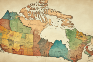
- Canada includes 10 provinces and 3 territories.
Provinces and Capitals
- British Columbia's capital is Victoria
- Alberta's capital is Edmonton
- Saskatchewan's capital is Regina
- Manitoba's capital is Winnipeg
- Ontario's capital is Toronto
- Quebec's capital is Quebec City
- New Brunswick's capital is Fredericton
- Nova Scotia's capital is Halifax
- Prince Edward Island's capital is Charlottetown
- Newfoundland and Labrador's capital is St. John’s
Territories and Capitals
- Yukon's capital is Whitehorse
- Northwest Territories' capital is Yellowknife
- Nunavut's capital is Iqaluit
Landform Regions of Canada
- Canada is divided into 7 landform regions.
- Western Cordillera: Includes the Rocky Mountains, located in British Columbia and Alberta.
- Interior Plains: Also known as the Prairies, spanning Alberta, Saskatchewan, and Manitoba.
- Canadian Shield: Covers parts of Ontario, Quebec, Manitoba, Saskatchewan, and Nunavut, characterized by lakes and forests.
- Hudson Bay Lowlands: Flat, swampy area surrounding Hudson Bay.
- Great Lakes-St. Lawrence Lowlands: Located in Southern Ontario and Quebec, known for fertile farmland.
- Appalachian Region: Found on the East Coast, including the Maritimes and Newfoundland and Labrador.
- Arctic and Innuitian Mountains: Northern Canada, featuring icy mountains.
Elements of a Good Map
- Title: States the purpose of the map
- Legend: Explains the symbols and colors used on the map
- Scale: Shows the relationship between distances on the map and corresponding distances on the ground
- Compass: Indicates direction, usually with a North arrow
- Labels: Identifies places, land features, or other map elements
Types of Maps
- Political: Shows borders, cities, and administrative divisions.
- Physical: Displays landforms, rivers, and elevation.
- Topographic: Uses contour lines to represent elevation changes.
- Thematic: Focuses on specific data such as climate or population distribution.
Definition of a Region
- A region is defined as an area with shared characteristics, whether physical, cultural, or economic.
GIS (Geographic Information System)
- GIS collects, analyzes, and displays spatial data.
- Examples of daily use: Google Maps, weather apps, Uber, and delivery tracking.
- Societal applications: City planning, disaster response, and environmental monitoring.
- Utility: Aids in data-driven decisions and visualizing spatial relationships.
Geographic Thinking
- Geographic thinking involves analyzing the world spatially and understanding human-environment interactions.
Four Concepts of Geographic Thinking
- Spatial Significance: Understanding the importance of a location.
- Patterns & Trends: Identifying patterns in data.
- Interrelationships: Examining how different places or factors influence each other.
- Geographic Perspective: Analyzing issues from environmental, political, economic, and social viewpoints.
Studying That Suits You
Use AI to generate personalized quizzes and flashcards to suit your learning preferences.