Podcast
Questions and Answers
What is the primary focus of physical geography?
What is the primary focus of physical geography?
- Urban and rural planning
- Natural features of the earth's surface (correct)
- Human population dynamics and migration patterns
- Economic systems and development
What geographic concept is used to measure distance north or south of the equator?
What geographic concept is used to measure distance north or south of the equator?
- Scale
- Longitude
- Projection
- Latitude (correct)
Which type of map is used to display specific data?
Which type of map is used to display specific data?
- Political map
- Physical map
- Thematic map (correct)
- Topographic map
What is the primary focus of human geography?
What is the primary focus of human geography?
What is the purpose of scale in geography?
What is the purpose of scale in geography?
Which of the following is NOT a type of geographic tool?
Which of the following is NOT a type of geographic tool?
What is the purpose of projection in geography?
What is the purpose of projection in geography?
Which type of map is used to show natural features and relief?
Which type of map is used to show natural features and relief?
What is the purpose of longitude in geography?
What is the purpose of longitude in geography?
What is the primary focus of geographic tools and techniques?
What is the primary focus of geographic tools and techniques?
Flashcards are hidden until you start studying
Study Notes
Branches of Geography
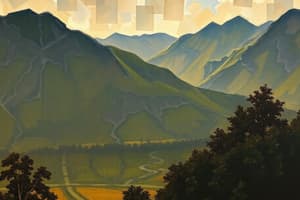
- Physical Geography: studies natural features of the earth's surface, such as:
- Landforms (mountains, valleys, etc.)
- Water bodies (oceans, rivers, lakes, etc.)
- Climate and weather patterns
- Natural resources (minerals, fossil fuels, etc.)
- Human Geography: focuses on human populations and their relationship with the environment, including:
- Population dynamics and migration patterns
- Cultural and social characteristics of different regions
- Economic systems and development
- Urban and rural planning
Geographic Concepts
- Latitude and Longitude: used to locate points on the earth's surface
- Latitude: measures distance north or south of the equator (0° to 90°)
- Longitude: measures distance east or west of the prime meridian (0° to 180°)
- Scale: the ratio of the distance on a map to the corresponding distance in reality
- Projection: a way of representing the curved earth's surface on a flat map, with different types of projections preserving different properties (e.g. shape, size, direction)
Geographic Tools and Techniques
- Maps: visual representations of geographic data, including:
- Topographic maps: show natural features and relief
- Thematic maps: display specific data (e.g. climate, population density)
- GIS (Geographic Information System) maps: use spatial data and analysis
- Remote Sensing: the acquisition of information about the earth's surface through aerial or satellite imagery
- GPS (Global Positioning System): a network of satellites providing location and time information
Geographic Regions and Features
- Continents: large, continuous areas of land, including:
- Africa, Antarctica, Asia, Australia, Europe, North America, South America
- Oceans: large bodies of saltwater, including:
- Pacific, Atlantic, Indian, Arctic, Southern
- Mountain Ranges: major mountain systems, such as:
- Himalayas, Andes, Rocky Mountains, Alps, Appalachian Mountains
Branches of Geography
- Physical Geography examines the natural features of the Earth's surface, including landforms, water bodies, climate, and natural resources.
- Human Geography focuses on the relationship between human populations and the environment, encompassing population dynamics, cultural characteristics, economic systems, and urban planning.
Geographic Concepts
- Latitude measures distance north or south of the equator (0° to 90°), while longitude measures distance east or west of the prime meridian (0° to 180°).
- Scale is the ratio of map distance to real-world distance, with different scales used for various purposes.
- Projection is a method of representing the curved Earth's surface on a flat map, with different types of projections preserving shape, size, or direction.
Geographic Tools and Techniques
- Maps are visual representations of geographic data, with types including topographic, thematic, and GIS maps.
- Remote Sensing involves acquiring information about the Earth's surface through aerial or satellite imagery.
- GPS (Global Positioning System) is a network of satellites providing location and time information.
Geographic Regions and Features
- There are seven continents: Africa, Antarctica, Asia, Australia, Europe, North America, and South America.
- The five oceans are the Pacific, Atlantic, Indian, Arctic, and Southern.
- Major mountain ranges include the Himalayas, Andes, Rocky Mountains, Alps, and Appalachian Mountains.
Studying That Suits You
Use AI to generate personalized quizzes and flashcards to suit your learning preferences.