Podcast
Questions and Answers
What is the scale of the topographic map of the BLIDA region?
What is the scale of the topographic map of the BLIDA region?
- 1:250,000 (correct)
- 1:1,000,000
- 1:500,000
- 1:100,000
Which contour interval is used on the topographic map of BLIDA?
Which contour interval is used on the topographic map of BLIDA?
- 500 meters
- 50 meters
- 100 meters (correct)
- 200 meters
What projection is utilized in the BLIDA topographic map?
What projection is utilized in the BLIDA topographic map?
- Lambert Conformal Conic
- Geographic Coordinate
- Universal Transverse Mercator
- Transverse Mercator (correct)
Which feature is NOT included in the map's legend?
Which feature is NOT included in the map's legend?
What information does the grid system on the topographic map provide?
What information does the grid system on the topographic map provide?
Quel élément est représenté par des couleurs et des ombres sur la carte topographique de BLIDA?
Quel élément est représenté par des couleurs et des ombres sur la carte topographique de BLIDA?
Quel type de système de coordonnées est utilisé sur la carte topographique de BLIDA?
Quel type de système de coordonnées est utilisé sur la carte topographique de BLIDA?
Quel est l'intervalle de contours employé sur la carte topographique de BLIDA?
Quel est l'intervalle de contours employé sur la carte topographique de BLIDA?
Quelle fonctionnalité est incluse dans la légende de la carte topographique de BLIDA?
Quelle fonctionnalité est incluse dans la légende de la carte topographique de BLIDA?
À quoi sert le diagramme de localisation sur la carte topographique de BLIDA?
À quoi sert le diagramme de localisation sur la carte topographique de BLIDA?
Flashcards
Topographic Map Scale
Topographic Map Scale
The ratio between distances on a map and corresponding distances on the ground.
Contour Interval
Contour Interval
The difference in elevation between two consecutive contour lines.
Coordinate System
Coordinate System
A system of reference to uniquely locate places on Earth's surface.
Elevation Visualization
Elevation Visualization
Signup and view all the flashcards
Map Legend
Map Legend
Signup and view all the flashcards
Projection
Projection
Signup and view all the flashcards
Le système de coordonnées
Le système de coordonnées
Signup and view all the flashcards
Le système de coordonnées NJ 31-14
Le système de coordonnées NJ 31-14
Signup and view all the flashcards
L'intervalle de contour
L'intervalle de contour
Signup and view all the flashcards
La carte indique l'altitude ?
La carte indique l'altitude ?
Signup and view all the flashcards
Study Notes
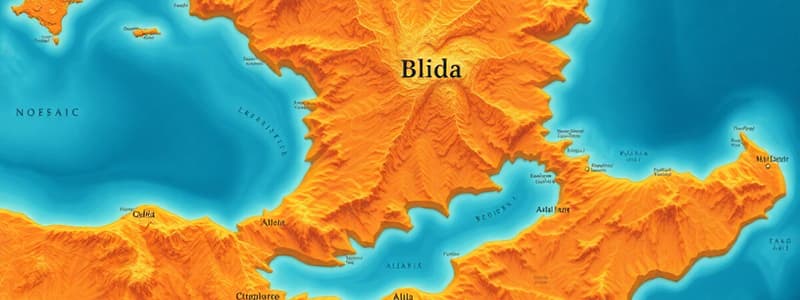
Map Information
- Map Title: BLIDA, Algeria
- Scale: 1:250,000
- Edition: 2-AMS
- Map Sheet: NJ 31-14
- Location: North Africa
- Geographic Features: Mediterranean Sea, coastal areas, terrain, populated places, roads, and other features
- Coordinate System: Transverse Mercator Projection
- Legend: Includes information on populated places, elevation, roads, vegetation, and other features. Details of population density are present
Studying That Suits You
Use AI to generate personalized quizzes and flashcards to suit your learning preferences.