Podcast
Questions and Answers
भौगोलिक अध्ययन के दो मुख्य शाखाएँ कौन सी हैं?
भौगोलिक अध्ययन के दो मुख्य शाखाएँ कौन सी हैं?
- भौतिक भूगोल और मानव भूगोल (correct)
- आर्थिक और सांस्कृतिक
- नैतिक और भौतिक
- जलवायु और जनसंख्या
भौतिक भूगोल मानव गतिविधियों का अध्ययन करता है।
भौतिक भूगोल मानव गतिविधियों का अध्ययन करता है।
False (B)
स्थान को परिभाषित करने में कौन-कौन से प्रकार होते हैं?
स्थान को परिभाषित करने में कौन-कौन से प्रकार होते हैं?
सटीक स्थान और सापेक्ष स्थान
भौजीकी में जलवायु अध्ययन के लिए __________ विषय महत्वपूर्ण है।
भौजीकी में जलवायु अध्ययन के लिए __________ विषय महत्वपूर्ण है।
नीचे दिए गए भूगोलिक विषयों को उनके विशेष उपयोगों के साथ मेल करें:
नीचे दिए गए भूगोलिक विषयों को उनके विशेष उपयोगों के साथ मेल करें:
वर्तमान भूगोल में कौन सा विषय प्रमुख है?
वर्तमान भूगोल में कौन सा विषय प्रमुख है?
भौगोलिक सूचना प्रणाली (GIS) केवल नक्शों के लिए उपयोग की जाती है।
भौगोलिक सूचना प्रणाली (GIS) केवल नक्शों के लिए उपयोग की जाती है।
पर्यावरण भूगोल में किन मुद्दों का अध्ययन किया जाता है?
पर्यावरण भूगोल में किन मुद्दों का अध्ययन किया जाता है?
Which of the following statements accurately describes the climate in Rajasthan?
Which of the following statements accurately describes the climate in Rajasthan?
The Ghaggar-Hakra River is a perennial river that flows year-round.
The Ghaggar-Hakra River is a perennial river that flows year-round.
Name two minerals that are abundant in Rajasthan.
Name two minerals that are abundant in Rajasthan.
The __________ is a major landform in Rajasthan, known for its sand dunes.
The __________ is a major landform in Rajasthan, known for its sand dunes.
Match the following wildlife sanctuaries with their notable species:
Match the following wildlife sanctuaries with their notable species:
Flashcards are hidden until you start studying
Study Notes
Definition of Geography
- Study of the Earth's landscapes, environments, and the relationships between people and their environments.
- Can be divided into two main branches: physical geography and human geography.
Physical Geography
- Focuses on natural features and processes.
- Landforms: mountains, valleys, plains, plateaus.
- Climate: weather patterns, temperature, precipitation.
- Biogeography: distribution of plants and animals.
- Hydrology: study of water bodies, rivers, lakes, and groundwater.
Human Geography
- Examines human activities and their relationship to the environment.
- Population Geography: demographics, migration patterns, population density.
- Cultural Geography: languages, religions, cultural landscapes.
- Economic Geography: trade, industry, agriculture.
- Urban Geography: cities, urbanization, spatial organization.
Tools and Techniques
- Maps: represent spatial relationships and geographical features.
- GIS (Geographic Information Systems): technology for mapping and analyzing spatial data.
- Remote Sensing: collecting data from satellite images and aerial photography.
Important Concepts
- Location: absolute (coordinates) vs. relative (compared to other locations).
- Place: characteristics that define a location (cultural, physical).
- Region: areas defined by similar characteristics (formal, functional, perceptual).
- Movement: flow of people, goods, and ideas.
- Human-Environment Interaction: how humans adapt to and modify their environment.
Major Themes in Geography
- Spatial Distribution: how phenomena are spread across space.
- Scale: local, regional, national, and global perspectives.
- Sustainability: managing resources to meet current needs without compromising future generations.
- Globalization: interconnectivity of economies and cultures across the world.
Regions of the World
- Continents: Africa, Antarctica, Asia, Australia, Europe, North America, South America.
- Cultural Regions: Middle East, Latin America, Sub-Saharan Africa, etc.
- Economic Regions: EU, NAFTA, ASEAN, etc.
Environmental Geography
- Interaction between humans and the physical environment.
- Issues include climate change, deforestation, pollution, and natural disasters.
Current Trends
- Increasing use of technology in mapping and data analysis.
- Greater emphasis on sustainability and environmental protection.
- The impact of climate change on geographical landscapes and human activities.
भूगोल की परिभाषा
- पृथ्वी के परिदृश्यों, पर्यावरणों, और लोगों और उनके पर्यावरणों के बीच के संबंधों का अध्ययन।
- मुख्यतः दो शाखाओं में विभाजित: भौतिक भूगोल और मानव भूगोल।
भौतिक भूगोल
- प्राकृतिक विशेषताओं और प्रक्रियाओं पर ध्यान केंद्रित करता है।
- भूमि रूप: पर्वत, घाटियाँ, मैदान, पठार।
- जलवायु: मौसम के पैटर्न, तापमान, वर्षा।
- जैव भूगोल: पौधों और जानवरों का वितरण।
- हाइड्रोलॉजी: जल निकायों, नदियों, झीलों और भूजल का अध्ययन।
मानव भूगोल
- मानव गतिविधियों और उनके पर्यावरण के साथ संबंध की जांच करता है।
- जनसंख्या भूगोल: जनसांख्यिकी, प्रवासन पैटर्न, जनसंख्या घनत्व।
- संस्कृतिक भूगोल: भाषाएँ, धर्म, सांस्कृतिक परिदृश्य।
- आर्थिक भूगोल: व्यापार, उद्योग, कृषि।
- शहरी भूगोल: नगर, शहरीकरण, स्थानिक संगठन।
उपकरण और तकनीकें
- नक्शे: स्थानिक संबंधों और भौगोलिक विशेषताओं का प्रतिनिधित्व करते हैं।
- GIS (भौगोलिक सूचना प्रणाली): स्थानिक डेटा के मैपिंग और विश्लेषण के लिए तकनीक।
- रिमोट सेंसिंग: उपग्रह चित्र और हवाई फ़ोटोग्राफी से डेटा संग्रह।
महत्वपूर्ण अवधारणाएँ
- स्थान: निरपेक्ष (निर्देशांक) बनाम सापेक्ष (अन्य स्थानों की तुलना में)।
- स्थान: एक स्थान को परिभाषित करने वाली विशेषताएँ (संस्कृतिक, भौतिक)।
- क्षेत्र: समान विशेषताओं से परिभाषित क्षेत्र (औपचारिक, कार्यात्मक, मानसिक)।
- आंदोलन: लोगों, सामनों और विचारों का प्रवाह।
- मानव-पर्यावरण इंटरैक्शन: कैसे मानव अपने पर्यावरण के अनुकूलन और परिवर्तन करता है।
भूगोल में मुख्य विषय
- स्थानिक वितरण: घटनाओं का स्थान पर बिखराव।
- स्केल: स्थानीय, क्षेत्रीय, राष्ट्रीय, और वैश्विक परिप्रेक्ष्य।
- स्थिरता: वर्तमान जरूरतों के लिए संसाधनों का प्रबंधन, भविष्य की पीढ़ियों का हानि न पहुँचना।
- वैश्वीकरण: विश्व भर में अर्थव्यवस्थाओं और संस्कृतियों का आपसी संबंध।
विश्व के क्षेत्र
- महाद्वीप: अफ्रीका, अंटार्कटिका, एशिया, ऑस्ट्रेलिया, यूरोप, उत्तरी अमेरिका, दक्षिण अमेरिका।
- संस्कृतिक क्षेत्र: मध्य पूर्व, लैटिन अमेरिका, उप-सहारा अफ्रीका, आदि।
- आर्थिक क्षेत्र: यूरोपीय संघ (EU), नॉर्थ अमेरिकन फ्री ट्रेड एग्रीमेंट (NAFTA), आसियान (ASEAN), आदि।
पर्यावरणीय भूगोल
- मानव और भौतिक पर्यावरण के बीच का अंतःक्रिया।
- मुद्दे: जलवायु परिवर्तन, वनों की कटाई, प्रदूषण, और प्राकृतिक आपदाएँ।
वर्तमान प्रवृत्तियाँ
- मैपिंग और डेटा विश्लेषण में प्रौद्योगिकी का बढ़ता उपयोग।
- स्थिरता और पर्यावरण सुरक्षा पर बढ़ता जोर।
- जलवायु परिवर्तन का भौगोलिक परिदृश्यों और मानव गतिविधियों पर प्रभाव।
जलवायु क्षेत्र
- आर्द्र जलवायु: मुख्य रूप से गर्म और शुष्क, वर्षा का स्तर कम है।
- अर्ध-आर्द्र जलवायु: पूर्वी हिस्सों में पाई जाती है, जहां वर्षा थोड़ी अधिक होती है।
- तापमान में भिन्नता: गर्मियों में तापमान 50°C तक, जबकि सर्दियों में लगभग 0°C तक गिर सकता है।
- मानसून का प्रभाव: दक्षिण-पश्चिम मानसून जून से सितंबर तक वर्षा पर प्रभाव डालता है।
प्राकृतिक संसाधन
- खनिज: जिप्सम, चूना पत्थर, तांबा, जस्ता और संगमरमर सहित खनिजों में समृद्ध।
- ऊर्जा संसाधन: ऊँचे सौर उष्मा के कारण सौर ऊर्जा का पर्याप्त потенциал; पवन ऊर्जा में भी महत्वपूर्ण संभावना।
- कृषि: शुष्क परिस्थितियों के कारण सीमित, लेकिन बाजरा, जौ और दालें सिंचाई के माध्यम से उगाई जाती हैं।
नदियाँ और जल निकाय
- मुख्य नदियाँ:
- सaraswati नदी: पौराणिक नदी, ऐतिहासिक महत्व रखती है।
- घग्घर-हाकरा नदी: मौसमी नदी, मानसून के दौरान प्रवाहित होती है।
- अन्य जल निकाय:
- राजस्थान नहर: प्रमुख सिंचाई स्रोत, सुतlej नदी से पानी लाती है।
- विभिन्न झीलें: पुष्कर झील, साम्भर झील (नमक झील)।
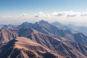
भौगोलिक आकृतियाँ
- थार रेगिस्तान: प्रमुख भूआकृति, रेत के टीलों और शुष्क परिदृश्यों से सुविधाजनक।
- अरावली पर्वत श्रृंखला: भारत की सबसे पुरानी पर्वत श्रृंखलाओं में से एक, राज्य के माध्यम से तिरछी रूप में फैली हुई है।
- उपत्यकाएँ और मैदान: मालवा पठार और पूर्व में उर्वर मैदानी क्षेत्रों का समावेश है।
जैव विविधता
- वनस्पति: मिश्रित वनस्पति; कैक्टस, एकेशिया और झाड़ीदार वन शामिल हैं।
- जन्तु जीवन:
- रणथंभौर (बाघ), सरिस्का (बाघ) और रेगिस्तानी राष्ट्रीय उद्यान (चिंकारा) जैसे वन्यजीव अभयारण्यों का समावेश।
- उल्लेखनीय प्रजातियों में भारतीय गजेल, रेगिस्तानी लोमड़ी और विभिन्न पक्षियों की प्रजातियाँ शामिल हैं।
- संरक्षण क्षेत्र: अद्वितीय रेगिस्तानी पारिस्थितिकी तंत्र और संकटग्रस्त प्रजातियों के संरक्षण पर जोर।
Studying That Suits You
Use AI to generate personalized quizzes and flashcards to suit your learning preferences.