Podcast
Questions and Answers
What is the elevation of Badwater Basin in feet below sea level?
What is the elevation of Badwater Basin in feet below sea level?
- 400
- 282 (correct)
- 200
- 100
How far is Badwater Basin from Mount Whitney?
How far is Badwater Basin from Mount Whitney?
- 84.6 miles (correct)
- 50 miles
- 200 miles
- 100 miles
What type of basin is Badwater Basin?
What type of basin is Badwater Basin?
- Glacier basin
- Endorheic basin (correct)
- Exorheic basin
- River basin
What is the primary composition of the salt flats in Badwater Basin?
What is the primary composition of the salt flats in Badwater Basin?
What happens to the water that enters Badwater Basin?
What happens to the water that enters Badwater Basin?
What was the approximate length of Lake Manly at its peak?
What was the approximate length of Lake Manly at its peak?
What has influenced the geological cycles of pluvial lakes forming and evaporating in the region?
What has influenced the geological cycles of pluvial lakes forming and evaporating in the region?
How deep could a lake in Badwater Basin be before it dries up in a year due to evaporation?
How deep could a lake in Badwater Basin be before it dries up in a year due to evaporation?
What happens to the salt flats in Badwater Basin when it rains?
What happens to the salt flats in Badwater Basin when it rains?
What is unique about the location of Badwater Basin?
What is unique about the location of Badwater Basin?
Study Notes
Low Point in North America
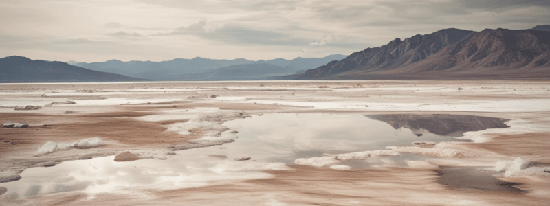
- Badwater Basin is the lowest point in North America, with an elevation of 282 feet (86 meters) below sea level.
- It is situated approximately 84.6 miles (136 km) from Mount Whitney, the highest point in the contiguous United States.
Geographical and Environmental Features
- Badwater Basin is an endorheic basin, meaning it does not drain into any ocean, and water only leaves through evaporation.
- The basin's salt flats cover nearly 200 square miles (518 square kilometers) and are primarily composed of sodium chloride, with other minerals like calcite, gypsum, and borax.
- The salt flats are hazardous to traverse due to the thin crust over mud in many areas.
- The area experiences significant rainstorms that periodically flood the valley, creating temporary lakes, but these lakes dry up quickly due to the high evaporation rate of 150 inches (3,800 mm) annually.
Historical and Geological Context
- Badwater Basin was once the site of Lake Manly, a large ancient lake that evaporated tens of thousands of years ago.
- At its peak, Lake Manly was approximately 80 miles (130 km) long and up to 600 feet (180 meters) deep.
- The region has undergone numerous cycles of pluvial lakes forming and evaporating over millions of years due to climatic changes and geological activities, including influences from the San Andreas Fault.
Low Point in North America
- Badwater Basin is the lowest point in North America, with an elevation of 282 feet (86 meters) below sea level.
- It is situated approximately 84.6 miles (136 km) from Mount Whitney, the highest point in the contiguous United States.
Geographical and Environmental Features
- Badwater Basin is an endorheic basin, meaning it does not drain into any ocean, and water only leaves through evaporation.
- The basin's salt flats cover nearly 200 square miles (518 square kilometers) and are primarily composed of sodium chloride, with other minerals like calcite, gypsum, and borax.
- The salt flats are hazardous to traverse due to the thin crust over mud in many areas.
- The area experiences significant rainstorms that periodically flood the valley, creating temporary lakes, but these lakes dry up quickly due to the high evaporation rate of 150 inches (3,800 mm) annually.
Historical and Geological Context
- Badwater Basin was once the site of Lake Manly, a large ancient lake that evaporated tens of thousands of years ago.
- At its peak, Lake Manly was approximately 80 miles (130 km) long and up to 600 feet (180 meters) deep.
- The region has undergone numerous cycles of pluvial lakes forming and evaporating over millions of years due to climatic changes and geological activities, including influences from the San Andreas Fault.
Studying That Suits You
Use AI to generate personalized quizzes and flashcards to suit your learning preferences.
Description
Learn about Badwater Basin, the lowest point in North America, its elevation, proximity to Mount Whitney, and its unique geographical and environmental features. Discover why it's an endorheic basin and how water behaves in this region.